
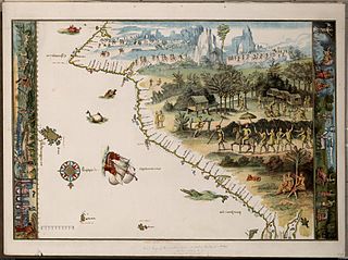
The Vallard Atlas is a world atlas, one of the Dieppe school of maps, produced in 1547. It is believed to have been owned by Nicolas Vallard, its authorship being unknown. [1]
The Vallard Atlas is a world atlas, one of the Dieppe school of maps, produced in 1547. It is believed to have been owned by Nicolas Vallard, its authorship being unknown. [1]
It is considered one of the most notable 16th-century atlases of the Dieppe school of Cartography. It is believed that Nicholas Vallard was the first owner and this is why the publication bears his name [2]
The atlas is held at the Huntington Library based in San Marino, California, USA.
The atlas consists of 68 pages, and contains 15 nautical charts with rich illustrations as well as a calendar and some in-depth maritime information. The atlas contains numerous illuminations that show the New World’s inhabitants, and this is why it is considered a valuable testimony of discovery. The original publication is bound in crimson leather with golden decorations.
The maps depicted in the atlas are inverted compared to modern depictions, as the North Pole is placed on the bottom side of the atlas while the South Pole is placed on the top. [3]
There is some speculation that like some other works of the Dieppe school of maps, the atlas may show the Australian coastline with its depiction of a continent labelled Jave la Grande, which would mean it was created before the documented discoveries of Willem Janszoon or James Cook. [3] [4] [5] However, most historians do not accept this theory, and the interpretation of this feature of the Vallard and other Dieppe maps is highly contentious. [6] [7] [8] [9] [10]

Terra Australis was a hypothetical continent first posited in antiquity and which appeared on maps between the 15th and 18th centuries. Its existence was not based on any survey or direct observation, but rather on the idea that continental land in the Northern Hemisphere should be balanced by land in the Southern Hemisphere. This theory of balancing land has been documented as early as the 5th century on maps by Macrobius, who uses the term Australis on his maps.

The maritime European exploration of Australia consisted of several waves of European seafarers who sailed the edges of the Australian continent. Dutch navigators were the first Europeans known to have explored and mapped the Australian coastline. The first documented encounter was that of Dutch navigator Willem Janszoon, in 1606. Dutch seafarers also visited the west and north coasts of the continent, as did French explorers.

The Piri Reis map is a world map compiled in 1513 by the Ottoman admiral and cartographer Piri Reis. Approximately one third of the map survives, housed in the Topkapı Palace in Istanbul. When rediscovered in 1929, the remaining fragment garnered international attention as the sole remaining copy of an otherwise lost map by Christopher Columbus.
The Mahogany Ship is a putative early Australian shipwreck that is believed by some to lie beneath the sand in the Armstrong Bay area, approximately 3 to 6 kilometres west of Warrnambool in southwest Victoria, Australia. In many modern accounts it is described as a Spanish or Portuguese caravel after the wreck was associated with the theory of Portuguese discovery of Australia by Kenneth McIntyre in his 1977 book The Secret Discovery of Australia. The most recent research has questioned this theory and provided other explanations.

The Dieppe maps are a series of world maps and atlases produced in Dieppe, France, in the 1540s, 1550s, and 1560s. They are large hand-produced works, commissioned for wealthy and royal patrons, including Kings Henry II of France and Henry VIII of England. The Dieppe school of cartographers included Pierre Desceliers, Jean Rotz, Guillaume Le Testu, Guillaume Brouscon and Nicolas Desliens.

The theory of Portuguese discovery of Australia claims that early Portuguese navigators were the first Europeans to sight Australia between 1521 and 1524, well before the arrival of Dutch navigator Willem Janszoon in 1606 on board the Duyfken who is generally considered to be the first European discoverer. While lacking generally accepted evidence, this theory is based on the following:
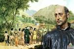
Cristóvão de Mendonça was a Portuguese noble and explorer who was active in South East Asia in the 16th century.
The earliest known world maps date to classical antiquity, the oldest examples of the 6th to 5th centuries BCE still based on the flat Earth paradigm. World maps assuming a spherical Earth first appear in the Hellenistic period. The developments of Greek geography during this time, notably by Eratosthenes and Posidonius culminated in the Roman era, with Ptolemy's world map, which would remain authoritative throughout the Middle Ages. Since Ptolemy, knowledge of the approximate size of the Earth allowed cartographers to estimate the extent of their geographical knowledge, and to indicate parts of the planet known to exist but not yet explored as terra incognita.

Portolan charts are nautical charts, first made in the 13th century in the Mediterranean basin and later expanded to include other regions. The word portolan comes from the Italian portulano, meaning "related to ports or harbors", and which since at least the 17th century designates "a collection of sailing directions".

Battista Agnese was a cartographer from the Republic of Genoa, who worked in the Venetian Republic.

Beyond Capricorn: How Portuguese adventurers secretly discovered and mapped Australia and New Zealand 250 years before Captain Cook is a 2007 book by journalist Peter Trickett on the theory of Portuguese discovery of Australia. Although its thesis is similar to that advanced by Kenneth McIntyre in 1977, Lawrence Fitzgerald in 1984 and others, the publisher and some news reports presented it as being a new theory on the discovery of Australia.
La grande isle de Java was, according to Marco Polo, the largest island in the world; his Java Minor was the actual island of Sumatra, which takes its name from the city of Samudera situated on its northern coast.

"Majorcan cartographic school" is the term coined by historians to refer to the collection of predominantly Jewish cartographers, cosmographers and navigational instrument-makers and some Christian associates that flourished in Majorca in the 13th, 14th and 15th centuries until the expulsion of the Jews. The label is usually inclusive of those who worked in Catalonia. The Majorcan school is frequently contrasted with the contemporary Italian cartography school.

Pierre Desceliers was a French cartographer of the Renaissance and an eminent member of the Dieppe School of Cartography. He is considered the father of French hydrography.
Guillaume Le Testu, sometimes referred to as Guillaume Le Têtu, was a French privateer, explorer and navigator. He was one of the foremost cartographers of his time and an author of the Dieppe maps. His maps were distinguished by their sophistication and detail; they influenced generations of cartographers, navigators and explorers.

Jean Rotz, also called Johne Rotz, was a 16th-century French artist-cartographer. He was born to a Scottish father and a French mother.

Regio Patalis is Latin for “the region of Patala”, that is the region around the ancient city of Patala at the mouth of the Indus River in Sindh, Pakistan. The historians of Alexander the Great state that the Indus parted into two branches at the city of Patala before reaching the sea, and the island thus formed was called Patalene, the district of Patala. Alexander constructed a harbour at Patala.

Emanuel Bowen was a Welsh map engraver, who achieved the unique distinction of becoming Royal Mapmaker to both to King George II of Great Britain and Louis XV of France. Bowen was highly regarded by his contemporaries for producing some of the largest, most detailed and most accurate maps of his era. He is known to have worked with most British cartographic figures of the period including John Owen and Herman Moll.
A rutter is a mariner's handbook of written sailing directions. Before the advent of nautical charts, rutters were the primary store of geographic information for maritime navigation.

The Vallard Atlas is an atlas produced in Dieppe, Northern France, in 1547. It was ascribed to Nicolas Vallard. However, there is a degree of uncertainty over his authorship. Nowadays, it is believed that the Vallard Atlas was developed from an earlier Portuguese prototype.