Adullam is an ancient ruin once numbered among the thirty-six cities of Canaan whose kings "Joshua and the children of Israel smote" (Joshua 12:7–24). After that, it fell as an inheritance to the tribe of Judah and was included in the northern division of the Shephelah "lowland" cities of the land of Judah (Joshua 15:35).

The Valley of Rephaim is a valley descending southwest from Jerusalem to Nahal Sorek below, it is an ancient route from the coastal plain to the Judean Hills, probably named after the legendary race of giants. Emek Refaim, the German Colony in Jerusalem, takes its name from this valley.

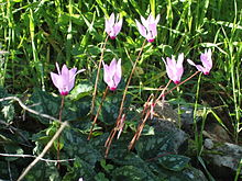
Pistacia is a genus of flowering plants in the cashew family, Anacardiaceae. It contains 10 to 20 species that are native to Africa and Eurasia from the Canary Islands, all of Africa, and southern Europe, warm and semidesert areas across Asia, and North America from Guatemala to Mexico, as well as southern Texas.
Elath, or Eloth, was an ancient city mentioned in several places in the Hebrew Bible on the northern tip of the Gulf of Aqaba. It was in the same vicinity as Ezion-Geber.

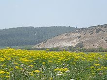
The Shephelah or Shfela, lit. "lowlands", is a transitional region of soft-sloping rolling hills in south-central Israel stretching over 10–15 km (6.2–9.3 mi) between the Judaean Mountains and the Coastal Plain. The different use of the term "Judean Plain", as either defining just the Coastal Plain segment stretching along the Judaean Mountains, or also including, or only referring to, the Shfela, often creates grave confusion.
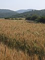
Azekah was an ancient town in the Shfela guarding the upper reaches of the Valley of Elah, about 26 km (16 mi) northwest of Hebron.
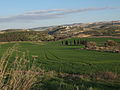
Aderet is a moshav in central Israel. Located in the Judean foothills in the Adullam region, south of Beit Shemesh, west of Gush Etzion and overlooking the Valley of Elah, it falls under the jurisdiction of Mateh Yehuda Regional Council. In 2022 it had a population of 895.

Pistacia terebinthus also called the terebinth and the turpentine tree, is a deciduous shrub species of the genus Pistacia, native to the Mediterranean region from the western regions of Morocco and Portugal to Greece and western and southeastern Turkey. At one time terebinths growing on the eastern shores of the Mediterranean Sea were regarded as a separate species, Pistacia palaestina, but these are now considered to be a synonym of P. terebinthus.

Keilah, meaning Citadel, was a city in the lowlands of Judah. It is now a ruin, known as Kh. Qeila, near the modern village of Qila, 7 miles (11 km) east of Beit Gubrin, and about 3 kilometres (1.9 mi) west of Kharas.
Sokho is the name given to two ancient towns in the territorial domain of Judah as mentioned in the Hebrew Bible, west of the Judean hills. Both towns were given the name Shuweikah in Arabic, a diminutive of the Arabic shawk, meaning "thorn". The remains of both have since been identified.
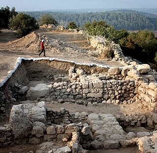
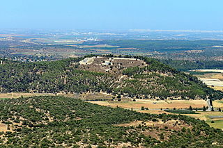
KhirbetQeiyafa, also known as Elah Fortress and in Hebrew as Horbat Qayafa, is the site of an ancient fortress city overlooking the Elah Valley and dated to the first half of the 10th century BCE. The ruins of the fortress were uncovered in 2007, near the Israeli city of Beit Shemesh, 30 km (20 mi) from Jerusalem. It covers nearly 2.3 ha and is encircled by a 700-meter-long (2,300 ft) city wall constructed of field stones, some weighing up to eight tons. Excavations at site continued in subsequent years. A number of archaeologists, mainly the two excavators, Yosef Garfinkel and Saar Ganor, have claimed that it might be one of two biblical cities, either Sha'arayim, whose name they interpret as "Two Gates", because of the two gates discovered on the site, or Neta'im; and that the large structure at the center is an administrative building dating to the reign of King David, where he might have lodged at some point. This is based on their conclusions that the site dates to the early Iron IIA, ca. 1025–975 BCE, a range which includes the biblical date for the biblical Kingdom of David. Others suggest it might represent either a North Israelite, Philistine, or Canaanite fortress, a claim rejected by the archaeological team that excavated the site. The team's conclusion that Khirbet Qeiyafa was a fortress of King David has been criticised by some scholars. Garfinkel (2017) changed the chronology of Khirbet Qeiyafa to ca. 1000–975 BCE.
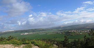
Neve Michael also known as Roglit, is a moshav in central Israel. Located in the Adullam region and built upon an eminence in the far south-east end of the Elah Valley, it falls under the jurisdiction of Mateh Yehuda Regional Council. In 2022 it had a population of 883.

Yosef Garfinkel is an Israeli archaeologist and academic. He is a professor of Prehistoric Archaeology and of Archaeology of the Biblical Period at the Hebrew University of Jerusalem.

Shaaraim, possibly meaning "Two Gates", is an Israelite city mentioned several times in the Hebrew Bible and the Old Testament. It has been identified by some with Khirbet Qeiyafa, an archaeological site on a hilltop overlooking the Elah Valley in the Judean hills.

Adullam Grove Nature Reserve is a nature reserve in central Israel, south of Beit Shemesh, managed by the Israel Nature and National Parks Protection Authority.

Nahal Tavor, lit.Tabor Stream, is an intermittent stream in the Lower Galilee, Israel.

Adullam-France Park, also known as Parc de France-Adoulam, is a sprawling park of 50,000 dunams (ca. 12,350 acres) in the Central District of Israel, located south of Beit Shemesh. The park, established in 2008 for public recreation, features two major hiking and biking trails, and four major archaeological sites from the Second Temple period. It stretches between Naḥal Ha-Elah, its northernmost boundary, to Naḥal Guvrin, its southernmost boundary. To its west lies the Beit Guvrin-Beit Shemesh highway, and to its east the "green line" – now territories under joint Israeli-Palestinian Arab control – which marks its limit.

Chezib, also known as Achzib of Judah, is a biblical place-name associated with the birth of Judah's son, Shelah (Genesis 38:5), corresponding to the Achzib of the Book of Joshua (15:44), a town located in the low-lying hills of the plain of Judah, known as the Shefela. In I Chronicles 4:22, the town is rendered as Chozeba. The place is now a ruin.

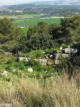
Rebbo or Horvat Rebbo, alternative spellings: Robbo, Ribbo; in Arabic Khurbet Rubba, is an ancient site in Israel, mentioned by Eusebius in his Onomasticon as possibly referring to a site by a similar name in the Book of Joshua. The site, which is now a ruin, sits on a hill 414 metres (1,358 ft) above sea level, in the Shephelah region, and is now part of the Adullam-France Park, maintained by the Jewish National Fund (KKL). It lies about 1.5 km. to the west of Aderet as the crow flies, and about 11 kilometres (7 mi) northeast of Beit Guvrin National Park.

Lavnin (Hebrew: חורבת לבנין)(Arabic: خربة تل البيضة), is a late Bronze Age archaeological site situated in Israel's Adullam region, rising some 389 metres (1,276 ft) above sea level. The site lies 8 kilometres (5.0 mi) northwest of Beit Gubrin, and about 1 kilometer west-north-west of Khirbat Umm Burj, directly south of Nehusha.