
Zoning is a method of urban planning in which a municipality or other tier of government divides land into areas called zones, each of which has a set of regulations for new development that differs from other zones. Zones may be defined for a single use, they may combine several compatible activities by use, or in the case of form-based zoning, the differing regulations may govern the density, size and shape of allowed buildings whatever their use. The planning rules for each zone determine whether planning permission for a given development may be granted. Zoning may specify a variety of outright and conditional uses of land. It may indicate the size and dimensions of lots that land may be subdivided into, or the form and scale of buildings. These guidelines are set in order to guide urban growth and development.
In United States constitutional law, a regulatory taking occurs when governmental regulations limit the use of private property to such a degree that the landowner is effectively deprived of all economically reasonable use or value of their property. Under the Fifth Amendment to the United States Constitution governments are required to pay just compensation for such takings. The amendment is incorporated to the states via the Due Process Clause of the Fourteenth Amendment.
A homeowner association, or a homeowner community, is a private association-like entity in the United States and Canada often formed either ipso jure in a building with multiple owner-occupancies, or by a real estate developer for the purpose of marketing, managing, and selling homes and lots in a residential subdivision. The developer will typically transfer control of the association to the homeowners after selling a predetermined number of lots.

In the United States, a plat (plan) is a cadastral map, drawn to scale, showing the divisions of a piece of land. United States General Land Office surveyors drafted township plats of Public Lands Surveys to show the distance and bearing between section corners, sometimes including topographic or vegetation information. City, town or village plats show subdivisions broken into blocks with streets and alleys. Further refinement often splits blocks into individual lots, usually for the purpose of selling the described lots; this has become known as subdivision.
Inclusionary zoning (IZ), also known as inclusionary housing, refers to municipal and county planning ordinances that require a given share of new construction to be affordable by people with low to moderate incomes. The term inclusionary zoning indicates that these ordinances seek to counter exclusionary zoning practices, which aim to exclude low-cost housing from a municipality through the zoning code. There are variations among different inclusionary zoning programs. Firstly, they can be mandatory or voluntary. Though voluntary programs exist, the great majority has been built as a result of local mandatory programmes requiring developers to include the affordable units in their developments. There are also variations among the set-aside requirements, affordability levels coupled with the period of control. In order to encourage engagements in these zoning programs, developers are awarded with incentives for engaging in these programs, such as density bonus, expedited approval and fee waivers.
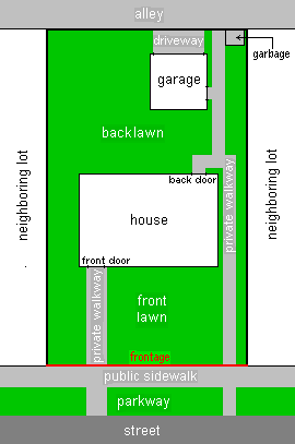
In land use, a setback is the minimum distance which a building or other structure must be set back from a street or road, a river or other stream, a shore or flood plain, or any other place which is deemed to need protection. Depending on the jurisdiction, other things like fences, landscaping, septic tanks, and various potential hazards or nuisances might be regulated and prohibited by setback lines. Setbacks along state, provincial, or federal highways may also be set in the laws of the state or province, or the federal government. Local governments create setbacks through ordinances, zoning restrictions, and Building Codes, usually for reasons of public policy such as safety, privacy, and environmental protection. Neighborhood developers may create setback lines to ensure uniform appearance in the neighborhood and prevent houses from crowding adjacent structures or streets. In some cases, building ahead of a setback line may be permitted through special approval.
A Form-Based Code (FBC) is a means of regulating land development to achieve a specific urban form. Form-Based Codes foster predictable built results and a high-quality public realm by using physical form as the organizing principle, with less focus on land use, through municipal regulations. An FBC is a regulation, not a mere guideline, adopted into city, town, or county law and offers a powerful alternative to conventional zoning regulation.
Dolan v. City of Tigard, 512 U.S. 374 (1994), more commonly Dolan v. Tigard, is a United States Supreme Court case. It is a landmark case regarding the practice of zoning and property rights, and has served to establish limits on the ability of cities and other government agencies to use zoning and land-use regulations to compel property owners to make unrelated public improvements as a condition to getting zoning approval, citing the violation of the Fifth Amendment’s Takings Clause.
In real estate, a lot or plot is a tract or parcel of land owned or meant to be owned by some owner(s). A plot is essentially considered a parcel of real property in some countries or immovable property in other countries. Possible owner(s) of a plot can be one or more person(s) or another legal entity, such as a company/corporation, organization, government, or trust. A common form of ownership of a plot is called fee simple in some countries.
The administrative divisions of Virginia are the areas into which the Commonwealth of Virginia, a U.S. state, is divided for political and administrative purposes. Some are local governments; others are not. However, all local governments are political subdivisions of the state.
Nonconforming use in urban planning is a type of zoning variance where a parcel of land may be given an exception from current zoning ordinances due to improvements made by a prior owner or before the current zoning ordinances made the desired use non-conforming under local law. Secondary suites are commonly permitted as a non-conforming use in the zoning district they are located in because the suite was developed prior to the zoning ordinance coming into effect.
A special-use permit authorizes land uses that are allowed and encouraged by the ordinance and declared harmonious with the applicable zoning district.
An abutter is a person whose property is adjacent to the property of another. In jurisdictions such as Massachusetts, New Hampshire, and Nova Scotia, it is a defined legal term. Some jurisdictions, such as Virginia, may use the term adjacent landowner, while others, such as California, use the term adjoining landowner, and the United States Environmental Protection Agency defines rights of contiguous property owners (CPO).
Spot zoning is the application of zoning to a specific parcel or parcels of land within a larger zoned area when the rezoning is usually at odds with a city's master plan and current zoning restrictions. Spot zoning may be ruled invalid as an "arbitrary, capricious and unreasonable treatment" of a limited parcel of land by a local zoning ordinance. While zoning regulates the land use in whole districts, spot zoning makes unjustified exceptions for a parcel or parcels within a district.

In the United States, zoning includes various land use laws falling under the police power rights of state governments and local governments to exercise authority over privately owned real property. Zoning laws in major cities originated with the Los Angeles zoning ordinances of 1904 and the New York City 1916 Zoning Resolution. Early zoning regulations were in some cases motivated by racism and classism, particularly with regard to those mandating single-family housing. Zoning ordinances did not allow African-Americans moving into or using residences that were occupied by majority whites due to the fact that their presence would decrease the value of home. The constitutionality of zoning ordinances was upheld by the Supreme Court of the United States in Village of Euclid, Ohio v. Ambler Realty Co. in 1926.
A secondary suite is a self contained dwelling, sometimes attached to the main dwelling, sometimes separate, which can be offered for rent to a third party by the owner/occupier. Some Canadian municipalities permit these while others do not, and rules vary as to what sort of dwellings are permitted to have secondary suites and what forms they may take.
A residential cluster development, or open space development, is the grouping of residential properties on a development site to use the extra land as open space, recreation or agriculture. It is increasingly becoming popular in subdivision development because it allows the developer to spend much less on land and obtain much the same price per unit as for detached houses. The shared garden areas can be a source of conflict, however. Claimed advantages include more green/public space, closer community, and an optimal storm water management. Cluster development often encounters planning objections.
Exclusionary zoning is the use of zoning ordinances to exclude certain types of land uses from a given community, especially to regulate racial and economic diversity. In the United States, exclusionary zoning ordinances are standard in almost all communities. Exclusionary zoning was introduced in the early 1900s, typically to prevent racial and ethnic minorities from moving into middle- and upper-class neighborhoods. Municipalities use zoning to limit the supply of available housing units, such as by prohibiting multi-family residential dwellings or setting minimum lot size requirements. These ordinances raise costs, making it less likely that lower-income groups will move in. Development fees for variance, a building permit, a certificate of occupancy, a filing (legal) cost, special permits and planned-unit development applications for new housing also raise prices to levels inaccessible for lower income people.
In recent years, communities in Massachusetts have adopted resource protection zoning (RPZ) as a tool to protect natural resources and open space. RPZ, which was originally passed in Shutesbury, Massachusetts in spring 2008, includes elements of conservation subdivision regulations and cluster development bylaws, to regulate new subdivisions of land in a manner that maximizes the protection of natural resources.

Missing middle housing is a term which describes a range of multi-family or clustered housing types that are compatible in scale with single-family or transitional neighborhoods. It is usually used to describe a phenomenon in Canada and the United States, and those countries which have sought to replicate their style of urban planning, which lacks this type of medium-density housing due to car dependant suburban sprawl. Missing middle housing is intended to meet the demand for walkable neighborhoods, respond to changing demographics, and provide housing at different price points. The term "missing middle" is meant to describe housing types that were common in the pre-WWII United States such as duplexes, rowhouses, and courtyard apartments but are now less common and, therefore, "missing". Rather than focusing on the number of units in a structure, missing middle housing emphasizes building at a human scale and heights that are appropriate for single-family neighborhoods or transitional neighborhoods. After the introduction of the term in 2010, the concept has been applied in the United States, Canada, and Australia.