
Nevada is a state in the Western region of the United States. It is bordered by Oregon to the northwest, Idaho to the northeast, California to the west, Arizona to the southeast, and Utah to the east. Nevada is the 7th-most extensive, the 32nd-most populous, and the 9th-least densely populated of the U.S. states. Nearly three-quarters of Nevada's people live in Clark County, which contains the Las Vegas–Paradise metropolitan area, including three of the state's four largest incorporated cities. Nevada's capital is Carson City. Las Vegas is the largest city in the state.

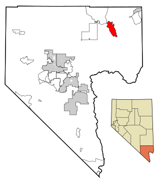
Clark County is located in the U.S. state of Nevada. As of the 2020 census, the population was 2,265,461. Most of the county population resides in the Las Vegas Census County Divisions, which hold 2,196,623 people as of the 2020 Census, across 435 square miles (1,130 km2). It is by far the most populous county in Nevada, and the 12th most populous county in the United States. It covers 7% of the state's land area but holds 73% of the state's population, making Nevada one of the most centralized states in the United States.

Nye County is a county in the U.S. state of Nevada. As of the 2020 census, the population was 51,591. Its county seat is Tonopah. At 18,159 square miles (47,030 km2), Nye is Nevada's largest county by area and the third-largest county in the contiguous United States, behind Coconino County of Arizona and San Bernardino County of California.

Blue Diamond is a census-designated place (CDP) in Clark County, Nevada, United States. The population was 268 at the 2020 census.

Bunkerville is a census-designated place in Clark County, Nevada, United States. The population was 1,303 at the 2010 census.

Cal-Nev-Ari is a census-designated place on U.S. Route 95 in Clark County, Nevada, United States, near the state's southernmost point. As of the 2010 census, the town had a population of 244. The town's name is a syllabic abbreviation of California, Nevada and Arizona.

Enterprise is an unincorporated town in the Las Vegas Valley in Clark County, Nevada, United States. The population was 221,831 at the 2020 U.S. Census, up from 14,676 at the 2000 census. It was founded on December 17, 1996. Like other unincorporated towns in the Las Vegas Valley, it uses Las Vegas ZIP codes for addresses within its boundaries.

Goodsprings is an unincorporated community in Clark County, Nevada, United States. The population was 229 at the 2010 census.

Indian Springs is an unincorporated town and a census-designated place located on U.S. Route 95 next to Creech Air Force Base in northwestern Clark County and southern Nevada.

Laughlin is an unincorporated resort town and census-designated place in Clark County, Nevada, United States. Laughlin lies 90 miles (140 km) south of Las Vegas, in the far southern tip of Nevada, and is known for its gaming and water recreation. It is located on the Colorado River, downstream from the Davis Dam and Lake Mohave, and directly across from the much larger Bullhead City, Arizona. As of the 2020 census, the population was 8,658. The nearby communities of Bullhead City, Arizona; Needles, California; Fort Mohave, Arizona; and Mohave Valley, Arizona, bring the area's total population to about 100,000. Laughlin is also 286 miles (460 km) northeast of Los Angeles.

Moapa is an unincorporated town and census-designated place (CDP) in Clark County, Nevada, United States. The population was 1,025 at the 2010 census. It is the largest town in Clark County by land area. Both the second and the third tallest structures in Nevada, the Moapa Entravision Tower and the Moapa Kemp Tower respectively, are located in Moapa.
Moapa Valley is an unincorporated town in Clark County, Nevada, United States. As of the 2010 census, it had a population of 6,924. The valley in which the community lies, also named Moapa Valley, is about 40 miles (64 km) long and lies roughly northwest to southeast.

Paradise is an unincorporated town and census-designated place (CDP) in Clark County, Nevada, United States, adjacent to the city of Las Vegas. It was formed on December 8, 1950. Its population was 191,238 at the 2020 census, making it the fifth most populous CDP in the United States; if it were an incorporated city, it would be the fifth largest in Nevada. As an unincorporated town, it is governed by the Clark County Commission with input from the Paradise Town Advisory Board.
Sandy Valley is an unincorporated community in the Mesquite Valley in west–central Clark County, Nevada, United States. Sandy Valley has a variant name of Sandy, Nevada. The population was 2,051 at the 2010 census. Sandy Valley is bordered on the East by the southern extension of the Spring Mountains and on the west by the California state line. Sandy Valley began in the 19th century as the five mining communities of Kingston, Sandy, Ripley, Mesquite and Platina. It is approximately forty-five miles from Las Vegas.

Searchlight is an unincorporated town and census-designated place (CDP) in Clark County, Nevada, United States, at the topographic saddle between two mountain ranges. At the 2020 census it had a population of 445.

Spring Valley is an unincorporated town and census-designated place in Clark County, Nevada, United States, located 2 miles (3 km) west of the Las Vegas Strip. The population was 215,597 at the 2020 census. Spring Valley was formed in May 1981.

Summerlin South, also seen on maps as South Summerlin, is a census-designated place (CDP) in Clark County, Nevada, United States, on the western edge of the Las Vegas Valley and adjacent to the Red Rock Canyon National Conservation Area. It is so named because it is a southward extension of the master-planned community of Summerlin. Nearly all of Summerlin South is in ZIP code 89135. The population was 24,085 at the 2010 Census.

Sunrise Manor is a census-designated place in Clark County, Nevada, United States, located on the western base of Frenchman Mountain, east of Las Vegas. The population was 205,618 at the 2020 census. If Sunrise Manor were to be incorporated, it would be one of the largest cities in Nevada. Sunrise Manor was formed in May 1957.
Whitney is an unincorporated town and census-designated place in Clark County, Nevada, United States. The population was 38,585 at the 2010 census.

Winchester is an unincorporated town and census-designated place (CDP) in Clark County, Nevada, United States that contains part of the Las Vegas Strip. It is one of a number of CDPs in the unincorporated urbanized area directly south of Las Vegas. The population was 36,403 at the 2020 census. It is governed by the Clark County Commission with advice from the Winchester Town Advisory Board. "Winchester, NV" does not appear in postal addresses; the United States Postal Service has assigned "Las Vegas, NV" as the place name for the ZIP codes containing Winchester.
