Venedocia, Ohio

Last updated

Venedocia, Ohio
Main below Plum, Venedocia.jpg
OHMap-doton-Venedocia.png
Location of Venedocia, Ohio
Map of Van Wert County Ohio Highlighting Venedocia Village.png
Location of Venedocia in Van Wert County
Coordinates: 40°47′06″N84°27′21″W / 40.78500°N 84.45583°W / 40.78500; -84.45583
Country United States
State Ohio
County Van Wert
Township Jennings, York
Government
   Mayor Sarah Kimmet[ citation needed ]
Area
[1]
  Total0.14 sq mi (0.36 km2)
  Land0.14 sq mi (0.36 km2)
  Water0.00 sq mi (0.00 km2)
Elevation
[2]
807 ft (246 m)
Population
 (2020)
  Total140
  Density1,014.49/sq mi (390.56/km2)
Time zone UTC-5 (Eastern (EST))
  Summer (DST) UTC-4 (EDT)
ZIP code
45894
Area code 419
FIPS code 39-79632
GNIS feature ID2400052 [2]
Website http://www.venedocia.org/

Venedocia is a village in Van Wert County, Ohio, United States. The population was 140 at the 2020 census. It is included within the Van Wert, Ohio Micropolitan Statistical Area and the Lima-Van Wert-Wapakoneta, OH Combined Statistical Area.

Contents

History

A post office called Venedocia has been in operation since 1866. [3] The village was originally built up chiefly by Welsh settlers. [4]

Geography

According to the United States Census Bureau, the village has a total area of 0.13 square miles (0.34 km2), all land. [5]

Demographics

Historical population
CensusPop.Note
1900 199
1910 24724.1%
1920 180−27.1%
1930 164−8.9%
1940 1746.1%
1950 170−2.3%
1960 20017.6%
1970 2021.0%
1980 161−20.3%
1990 158−1.9%
2000 1601.3%
2010 124−22.5%
2020 14012.9%
U.S. Decennial Census [6]

2010 census

As of the census [7] of 2010, there were 124 people, 53 households, and 30 families living in the village. The population density was 953.8 inhabitants per square mile (368.3/km2). There were 58 housing units at an average density of 446.2 per square mile (172.3/km2). The racial makeup of the village was 97.6% White, 0.8% African American, and 1.6% from two or more races.

There were 53 households, of which 24.5% had children under the age of 18 living with them, 47.2% were married couples living together, 7.5% had a female householder with no husband present, 1.9% had a male householder with no wife present, and 43.4% were non-families. 39.6% of all households were made up of individuals, and 15.1% had someone living alone who was 65 years of age or older. The average household size was 2.34 and the average family size was 3.10.

The median age in the village was 42 years. 20.2% of residents were under the age of 18; 7.9% were between the ages of 18 and 24; 24.2% were from 25 to 44; 33% were from 45 to 64; and 14.5% were 65 years of age or older. The gender makeup of the village was 54.0% male and 46.0% female.

2000 census

As of the census [8] of 2000, there were 160 people, 59 households, and 43 families living in the village. The population density was 1,196.7 inhabitants per square mile (462.0/km2). There were 63 housing units at an average density of 471.2 per square mile (181.9/km2). The racial makeup of the village was 98.12% White, and 1.88% from two or more races. Hispanic or Latino of any race were 0.62% of the population.

There were 59 households, out of which 40.7% had children under the age of 18 living with them, 57.6% were married couples living together, 13.6% had a female householder with no husband present, and 27.1% were non-families. 23.7% of all households were made up of individuals, and 13.6% had someone living alone who was 65 years of age or older. The average household size was 2.71 and the average family size was 3.12.

In the village, the population was spread out, with 27.5% under the age of 18, 8.1% from 18 to 24, 28.8% from 25 to 44, 17.5% from 45 to 64, and 18.1% who were 65 years of age or older. The median age was 40 years. For every 100 females there were 77.8 males. For every 100 females age 18 and over, there were 78.5 males.

The median income for a household in the village was $31,250, and the median income for a family was $41,250. Males had a median income of $26,667 versus $20,000 for females. The per capita income for the village was $11,761. About 10.0% of families and 13.0% of the population were below the poverty line, including 6.5% of those under the age of eighteen and 23.1% of those 65 or over.

Related Research Articles

<span class="mw-page-title-main">Van Wert County, Ohio</span> County in Ohio, United States

Van Wert County is a county located in the U.S. state of Ohio. As of the 2020 census, the population was 28,931. Its county seat is Van Wert. The county was created on February 12, 1820, and later organized on March 18, 1837. It is named for Isaac Van Wart, one of the captors of John André in the American Revolutionary War.

<span class="mw-page-title-main">Van Wert, Iowa</span> City in Iowa, United States

Van Wert is a city in northern Decatur County, Iowa, United States. The population was 178 at the time of the 2020 census.

<span class="mw-page-title-main">Groveport, Ohio</span> City in Ohio, United States

Groveport is a city in Franklin County, Ohio, United States. It is a suburb of Columbus. The population was 6,009 at the 2020 census.

<span class="mw-page-title-main">Addyston, Ohio</span> Village in Ohio, United States

Addyston is a village in Miami Township, Hamilton County, Ohio, United States. Located along the Ohio River, it is a western suburb of the neighboring city of Cincinnati. The population was 927 at the 2020 census.

<span class="mw-page-title-main">Cleves, Ohio</span> City in Ohio, United States

Cleves is a village in Miami Township, Hamilton County, Ohio, United States. Located along the Ohio River, it is a western suburb of Cincinnati. The population was 3,414 at the 2020 census.

<span class="mw-page-title-main">Evendale, Ohio</span> Village in Ohio, United States

Evendale is a village in Hamilton County, Ohio, United States, within the Cincinnati metropolitan area. The population was 2,669 at the 2020 census.

<span class="mw-page-title-main">Jenera, Ohio</span> Village in Ohio, United States

Jenera is a village in Hancock County, Ohio, United States. The population was 257 at the 2020 census. It is surrounded by Van Buren Township and is part of the Cory-Rawson Local School District.

<span class="mw-page-title-main">Mowrystown, Ohio</span> Village in Ohio, United States

Mowrystown is a village in Highland County, Ohio, United States. The population was 385 at the 2020 census.

<span class="mw-page-title-main">Port Jefferson, Ohio</span> Village in Ohio, United States

Port Jefferson is a village in Salem Township, Shelby County, Ohio, United States. The population was 308 at the 2020 census.

<span class="mw-page-title-main">Limaville, Ohio</span> Census-designated place in Ohio, United States

Limaville is a census-designated place (CDP) and former village in Stark County, Ohio, United States. The population was 151 at the 2020 census. It is part of the Canton–Massillon Metropolitan Statistical Area.

<span class="mw-page-title-main">Convoy, Ohio</span> Village in Ohio, United States

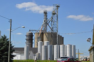
Convoy is a village in Van Wert County, Ohio, United States. The population was 1,012 at the 2020 census. It is included in the Van Wert, Ohio Micropolitan Statistical Area.

<span class="mw-page-title-main">Elgin, Ohio</span> Village in Ohio, United States

Elgin is a village in Van Wert County, Ohio, United States. The population was 49 at the 2020 census. It is included within the Van Wert, Ohio Micropolitan Statistical Area.

<span class="mw-page-title-main">Middle Point, Ohio</span> Village in Ohio, United States

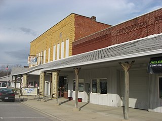
Middle Point is a village in Van Wert County, Ohio, United States. The population was 566 at the 2020 census. It is included within the Van Wert, Ohio Micropolitan Statistical Area.

<span class="mw-page-title-main">Ohio City, Ohio</span> Village in Ohio, United States

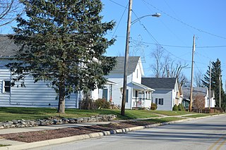
Ohio City is a village in Liberty Township, Van Wert County, Ohio, United States. The population was 651 at the 2020 census. It is included within the Van Wert, Ohio Micropolitan Statistical Area.

<span class="mw-page-title-main">Van Wert, Ohio</span> City in Ohio, United States

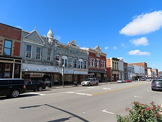
Van Wert is a city in and the county seat of Van Wert County, Ohio, United States. It is located in northwestern Ohio approximately 77 miles (124 km) southwest of Toledo and 34 miles (55 km) southeast of Fort Wayne, Indiana. The population was 11,092 at the 2020 census. It is the principal city of the Van Wert micropolitan area, which is included in the Lima–Van Wert–Wapakoneta combined statistical area.

<span class="mw-page-title-main">Willshire, Ohio</span> Village in Ohio, United States

Willshire is a village in Van Wert County, Ohio, United States. The population was 405 at the 2020 census. It is included within the Van Wert, Ohio Micropolitan Statistical Area.

<span class="mw-page-title-main">Wren, Ohio</span> Village in Ohio, United States

Wren is a village in Van Wert County, Ohio, United States. The population was 165 at the 2020 census. It is included within the Van Wert, Ohio Micropolitan Statistical Area.

<span class="mw-page-title-main">Macksburg, Ohio</span> Village in Ohio, United States

Macksburg is a village in Washington County, Ohio, United States, along the West Fork of Duck Creek. The population was 120 at the 2020 census. The village is about 28 miles (45 km) south of Cambridge, Ohio.

<span class="mw-page-title-main">Delphos, Ohio</span> City in Ohio, United States

Delphos is a city in Allen and Van Wert counties in the U.S. state of Ohio approximately 14 mi (23 km) northwest of Lima and 13 mi (21 km) east of Van Wert. The population was 7,117 at the 2020 census.

<span class="mw-page-title-main">Scott, Ohio</span> Village in Ohio, United States

Scott is a village in Paulding and Van Wert counties in the U.S. state of Ohio. The population was 242 at the 2020 census. The Van Wert County portion of Scott is part of the Van Wert Micropolitan Statistical Area.

References

  1. "ArcGIS REST Services Directory". United States Census Bureau. Retrieved September 20, 2022.
  2. 1 2 U.S. Geological Survey Geographic Names Information System: Venedocia, Ohio
  3. "Van Wert County". Jim Forte Postal History. Retrieved December 13, 2015.
  4. Gilliland, Thaddeus Stephens (1906). History of Van Wert County, Ohio and Representative Citizens. Windmill Publications. p. 171.
  5. "US Gazetteer files 2010". United States Census Bureau. Archived from the original on July 2, 2012. Retrieved January 6, 2013.
  6. "Census of Population and Housing". Census.gov. Retrieved June 4, 2015.
  7. "U.S. Census website". United States Census Bureau . Retrieved January 6, 2013.
  8. "U.S. Census website". United States Census Bureau . Retrieved January 31, 2008.