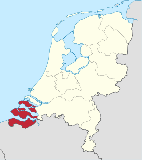
Zeeland is the westernmost and least populous province of the Netherlands. The province, located in the south-west of the country, borders North Brabant to the east and South Holland to the north. It consists of a number of islands and peninsulas and a strip bordering the Flemish provinces of East and West Flanders. Its capital is Middelburg with a population of 48,544 as of November 2019, the largest municipality in Zeeland is Terneuzen. Zeeland has two seaports: Vlissingen and Terneuzen. Its area is 2,934 square kilometres (1,130 sq mi), of which 1,151 square kilometres (440 sq mi) is water, and it has a population of 383,689 as of November 2019.

The Eastern Scheldt is a former estuary in the province of Zeeland, Netherlands, between Schouwen-Duiveland and Tholen on the north and Noord-Beveland and Zuid-Beveland on the south. It is also the largest national park in the Netherlands, founded in 2002.

Hulst is a municipality and city in southwestern Netherlands in the east of Zeelandic Flanders.

Kapelle is a municipality and a town in the southwestern Netherlands on Zuid-Beveland. As of January 2017, the municipality's population amounts to 12,620.
The name Reimerswaal can mean:

Bergen op Zoom is a municipality and a city located in the south of the Netherlands.

Zuid-Beveland is part of the province of Zeeland in the Netherlands north of the Western Scheldt and south of the Eastern Scheldt.
The Scheldt–Rhine Canal (Schelde-Rijnkanaal) in Belgium and the Netherlands connects Antwerp with the Volkerak, and thereby the Scheldt with the Rhine.

Lepelstraat is a small Dutch community six kilometres north of the city of Bergen op Zoom, and part of the municipality with that name. It has 2,342 inhabitants and 30 percent of the municipality consists of farmland. Its earliest records of history date back to 1298 where in a manuscript of landrights it was mentioned as "Den Leepel Straet."
Oost-Souburg is a town in the municipality of Vlissingen.

The All Saints' Flood (Allerheiligenvloed) of 1570 was a disaster which happened on November 1, on the Dutch and German coast. Affected cities include Egmond, Bergen op Zoom and Saeftinghe.
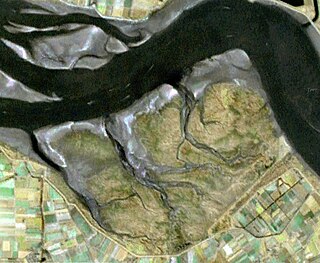
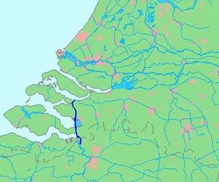
Saeftinghe or Saaftinge was a town in the southwest Netherlands, located in eastern Zeelandic Flanders, near Nieuw-Namen. It existed until 1584. It is now a swamp known as the Drowned Land of Saeftinghe and an official nature reserve area. The land is a crosspoint where the river Scheldt meets the salty waters of the North Sea in the estuary Western Scheldt. It is a treacherous place where the tides easily consume large stretches of land in a matter of seconds and must not be explored without an experienced guide.

The Dollart or Dollard is a bay in the Wadden Sea between the northern Netherlands and Germany, on the west side of the estuary of the Ems river. Most of it dries at low tide. Many water birds feed there.

Kruiningen is a village in the Dutch province of Zeeland. It is located in the municipality of Reimerswaal, about 5 km south of the village of Yerseke.

The St. Felix's flood happened on Saturday, 5 November 1530, the name day of St. Felix. This day was later known as Evil Saturday (kwade zaterdag). Large parts of Flanders and Zeeland were washed away, including the Verdronken Land van Reimerswaal. According to Audrey M. Lambert, "all the Oost Wetering of Zuid-Beveland was lost, save only the town of Reimerswaal."
Drowned lands is a name sometimes given to seasonally flooded areas, or to areas flooded by reservoirs. Sometimes it is poetically applied to lands said to have been lost to the sea, such as Lyonesse.

Bath is a small village and a former municipality in the Dutch province of Zeeland, lying on the north shore of the Western Scheldt. It is now located in the municipality of Reimerswaal, about 10 km southwest of Bergen op Zoom. Bath has a population of about 90.

In August 1572, during the course of the Eighty Years' War, the city of Goes, in the Spanish Netherlands, was besieged by Dutch forces with the support of English troops sent by Queen Elizabeth I. This was a menace to the safety of the nearby city of Middelburg, also under siege. Given the impossibility of rescue of Goes by sea, 3,000 soldiers of the Spanish Tercios under the command of Cristóbal de Mondragón waded across the river Scheldt at its mouth, walking 15 miles overnight in water up to chest deep. The surprise arrival of the Tercios forced the withdrawal of the Anglo-Dutch troops from Goes, allowing the Spanish to maintain control of Middelburg, capital of Walcheren Island.

Reimerswaal is a lost city in the Netherlands. The present-day municipality of Reimerswaal is named after this city, which was granted city rights in 1374. The city was destroyed by repeated floods, and the last citizens left in 1632. Nothing remains. It was located north of the current municipality, on the east end of the Oosterschelde, on land which is now called the Verdronken Land van Reimerswaal. The site of the city has been recognized as a national archeological monument and is buried under the Oesterdam.

The Markiezaatskade is a 4 km (2.5 mi) long dam between Zuid-Beveland and the Molenplaat near Bergen op Zoom. The dam was built in preparation for the construction of the Oesterdam, which was built a few years later. In combination with the Oesterdam, Philipsdam and Volkerakdam it divides the waters of Zeeland and South Holland.


