Related Research Articles

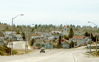
Ely is a city in Saint Louis County, Minnesota, United States. The population was 3,268 at the 2020 census.

The Klondike Gold Rush was a migration by an estimated 100,000 prospectors to the Klondike region of Yukon, in north-western Canada, between 1896 and 1899. Gold was discovered there by local miners on August 16, 1896; when news reached Seattle and San Francisco the following year, it triggered a stampede of prospectors. Some became wealthy, but the majority went in vain. It has been immortalized in films, literature, and photographs.

Prospecting is the first stage of the geological analysis of a territory. It is the search for minerals, fossils, precious metals, or mineral specimens. It is also known as fossicking.

The Iron Range is collectively or individually a number of elongated iron-ore mining districts around Lake Superior in the United States and Canada. Much of the ore-bearing region lies alongside the range of granite hills formed by the Giants Range batholith. These cherty iron ore deposits are Precambrian in the Vermilion Range and middle Precambrian in the Mesabi and Cuyuna ranges, all in Minnesota. The Gogebic Range in Wisconsin and the Marquette Iron Range and Menominee Range in Michigan have similar characteristics and are of similar age. Natural ores and concentrates were produced from 1848 until the mid-1950s, when taconites and jaspers were concentrated and pelletized, and started to become the major source of iron production.

The Chilkoot Trail is a 33-mile (53 km) trail through the Coast Mountains that leads from Dyea, Alaska, in the United States, to Bennett, British Columbia, in Canada. It was a major access route from the coast to Yukon goldfields in the late 1890s. The trail became obsolete in 1899 when a railway was built from Dyea's neighbor port Skagway along the parallel White Pass trail.

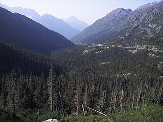
White Pass, also known as the Dead Horse Trail, is a mountain pass through the Boundary Ranges of the Coast Mountains on the border of the U.S. state of Alaska and the province of British Columbia, Canada. It leads from Skagway, Alaska, to the chain of lakes at the headwaters of the Yukon River, Crater Lake, Lake Lindeman, and Bennett Lake.

The Otago Gold Rush was a gold rush that occurred during the 1860s in Central Otago, New Zealand. This was the country's biggest gold strike, and led to a rapid influx of foreign miners to the area – many of them veterans of other hunts for the precious metal in California and Victoria, Australia.

Lake Vermilion is a shallow freshwater lake in northeastern Minnesota, United States. The Ojibwe originally called the lake Onamanii-zaaga'iganiing, which means “the evening sun tinting the water a reddish color”. French fur traders translated this to the Latin word Vermilion, which is a red pigment. Lake Vermilion is located between the towns of Tower on the east and Cook on the west, in the heart of Minnesota's Arrowhead Region at Vermilion Iron Range. The area was mined from the late 19th century until the 1960s, and the Soudan Mine operated just south of the lake.

The Cuyuna Range is an inactive iron range to the southwest of the Mesabi Range, largely within Crow Wing County, Minnesota. It lies along a 68-mile-long (109 km) line between Brainerd, Minnesota, and Aitkin, Minnesota. The width ranges from 1 to 10 miles.

The North Shore of Lake Superior runs from Duluth, Minnesota, United States, at the western end of the lake, to Thunder Bay and Nipigon, Ontario, Canada, in the north, to Sault Ste. Marie, Ontario in the east. The shore is characterized by alternating rocky cliffs and cobblestone beaches, with forested hills and ridges through which scenic rivers and waterfalls descend as they flow to Lake Superior.

The Lake Vermilion-Soudan Underground Mine State Park is a Minnesota state park at the site of the Soudan Underground Mine, on the south shore of Lake Vermilion, in the Vermilion Range (Minnesota). The mine is known as Minnesota's oldest, deepest, and richest iron mine. It formerly hosted the Soudan Underground Laboratory. As the Soudan Iron Mine, it has been designated a U.S. National Historic Landmark.
The Similkameen Gold Rush, also known as the Blackfoot Gold Rush, was a minor gold rush in the Similkameen Country of the Southern Interior of British Columbia, Canada, in 1860. The Similkameen Rush was one of a flurry of small rushes peripheral to the Fraser Canyon Gold Rush, which had drawn tens of thousands of prospectors to the new colony in 1858-1859, among the others being Rock Creek Gold Rush and Big Bend.

Buyck is an unincorporated community in Portage Township, Saint Louis County, Minnesota, United States.

The Porcupine Gold Rush was a gold rush that took place in Northern Ontario starting in 1909 and developing fully by 1911. A combination of the hard rock of the Canadian Shield and the rapid capitalization of mining meant that smaller companies and single-man operations could not effectively mine the area, as opposed to earlier rushes where the gold could be extracted through placer mining techniques. Although a number of prospectors made their fortune, operations in the area are marked largely by the development of larger mining companies, and most people involved in the mining operations were their employees.
Reuben Bennett "Sourdough" D'Aigle (1874–1959) was a Canadian prospector who made numerous discoveries in the Klondike, Ontario, Quebec and Labrador. Although successful with several of these ventures, he remains best known for missing the Porcupine Gold Rush by only a few feet, a huge deposit being discovered directly beside one of his abandoned test digs. His last major discovery was a major iron deposit in Labrador, although he was unable to personally develop the site due to the Wall Street Crash of 1929, which dried up development funds. He was so well known that his death was mentioned in Time Magazine, who quoted his easygoing take on his losses in Labrador; "I was just there a darn sight too soon, but I have certainly enjoyed myself."

The Temagami Greenstone Belt (TGB) is a small 2.7 billion year old greenstone belt in the Temagami region of Northeastern Ontario, Canada. It represents a feature of the Superior craton, an ancient and stable part of the Earth's lithosphere that forms the core of the North American continent and Canadian Shield. The belt is composed of metamorphosed volcanic rocks that range in composition from basalt to rhyolite. These form the east-northeast trend of the belt and are overlain by metamorphosed sedimentary rocks. They were created during several volcanic episodes involving a variety of eruptive styles ranging from passive lava eruptions to viscous explosive eruptions.

The city of Timmins, Ontario, Canada contains many named neighbourhoods. Some former municipalities that were merged into Timmins continue to be treated as distinct postal and telephone exchanges from the city core.

The Kobuk River Stampede was a brief gold rush on the Kobuk River in Alaska. From 1897 to 1898, several false accounts of the discovery of gold on the Kobuk led nearly 2,000 gold seekers to the area. Most of these prospectors arrived by ship, during the spring of 1898, from the West Coast of North America. The gold rush was brief, with its peak from 1898 to 1899, for local people spread the word upon arrival that no gold was to be found. Out of these 2,000 people, only 800 remained to search; and despite their efforts, only small amounts of placer and lode gold were discovered on a few of the Kobuk's tributaries. Other than the gold deposits, copper, asbestos and lead were also found.

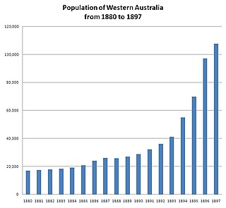
In the latter part of the nineteenth century, discoveries of gold at a number of locations in Western Australia caused large influxes of prospectors from overseas and interstate, and classic gold rushes. Significant finds included:

The Nome Gold Rush was a gold rush in Nome, Alaska, approximately 1899–1909. It is separated from other gold rushes by the ease with which gold could be obtained. Much of the gold was lying in the beach sand of the landing place and could be recovered without any need for a claim. Nome was a sea port without a harbor, and the biggest town in Alaska.