
Giovanni da Verrazzano was an Italian (Florentine) explorer of North America, in the service of King Francis I of France.

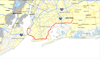
The Verrazzano-Narrows Bridge is a suspension bridge connecting the New York City boroughs of Staten Island and Brooklyn. It spans the Narrows, a body of water linking the relatively enclosed Upper New York Bay with Lower New York Bay and the Atlantic Ocean. It is the only fixed crossing of the Narrows. The double-deck bridge carries 13 lanes of Interstate 278, with seven lanes on the upper level and six on the lower level. The span is named for Giovanni da Verrazzano, who in 1524 was the first European explorer to enter New York Harbor and the Hudson River.
Interstate 278 (I-278) is an auxiliary Interstate Highway in New Jersey and New York in the United States. The road runs 35.62 miles (57.32 km) from U.S. Route 1/9 (US 1/9) in Linden, New Jersey, northeast to the Bruckner Interchange in the New York City borough of the Bronx. The majority of I-278 is in New York City, where it serves as a partial beltway and passes through all five of the city's boroughs. I-278 follows several freeways, including the Union Freeway in Union County, New Jersey; the Staten Island Expressway (SIE) across Staten Island; the Gowanus Expressway in southern Brooklyn; the Brooklyn–Queens Expressway (BQE) across northern Brooklyn and Queens; a small part of the Grand Central Parkway in Queens; and a part of the Bruckner Expressway in the Bronx. I-278 also crosses multiple bridges, including the Goethals, Verrazzano-Narrows, Kosciuszko, and Triborough Bridges.
The Belt Parkway is the name given to a series of connected limited-access highways that form a belt-like circle around the New York City boroughs of Brooklyn and Queens. The Belt Parkway comprises three of the four parkways in what is known as the Belt System: the Shore Parkway, the Southern Parkway, and the Laurelton Parkway. The three parkways in the Belt Parkway are a combined 25.29 miles (40.70 km) in length. The Cross Island Parkway makes up the fourth parkway in the system, but is signed separately.

The Chesapeake Bay Bridge–Tunnel is a 17.6-mile (28.3 km) bridge–tunnel that crosses the mouth of the Chesapeake Bay between Delmarva and Hampton Roads in the U.S. state of Virginia. It opened in 1964, replacing ferries that had operated since the 1930s. A major project to dualize its bridges was completed in 1999, and a similar project to dualize one of its tunnels is currently underway.

The Eastern Shore of Virginia consists of two counties on the Atlantic coast detached from the mainland of the Commonwealth of Virginia in the United States. The 70-mile-long (110 km) region is part of the Delmarva Peninsula and is separated from the rest of Virginia by the Chesapeake Bay. Its population was 45,695 as of 2020.

The Eastern Shore of Maryland is a part of the U.S. state of Maryland that lies mostly on the east side of the Chesapeake Bay. Nine counties are normally included in the region. The Eastern Shore is part of the larger Delmarva Peninsula that Maryland shares with Delaware and Virginia.

Assateague Island is a 37-mile (60 km) long barrier island located off the eastern coast of the Delmarva Peninsula facing the Atlantic Ocean. The northern two-thirds of the island is in Maryland while the southern third is in Virginia. The Maryland section contains the majority of Assateague Island National Seashore and Assateague State Park. The Virginia section contains Chincoteague National Wildlife Refuge and a one-mile stretch of land containing the lifeguarded recreational beach and interpretive facilities managed by the National Park Service. It is best known for its herds of feral horses, pristine beaches and the Assateague Lighthouse. The island also contains numerous marshes, bays, and coves, including Toms Cove. Bridge access for cars is possible from both Maryland and Virginia, though no road runs the full north/south length of the island.
The Jamestown Bridge was a cantilever truss bridge that connected Conanicut Island to mainland North Kingstown, Rhode Island, spanning the West passage of Narragansett Bay. The bridge first opened to traffic in 1940, replacing ferry service as the primary connection for the town of Jamestown, situated on Conanicut Island. It was constructed for just over $3 million 1940 USD, which was paid for by tolls until June 28, 1969. With a total length of 6,892 feet, the Jamestown Bridge was the third longest in Rhode Island at the time of its destruction, ranking behind its replacement, the adjacent 7,350-foot Jamestown Verrazzano Bridge, and the 11,248-foot Claiborne Pell Newport Bridge connecting Conanicut Island to Aquidneck Island and Newport. The Jamestown Bridge was closed to vehicular traffic on October 8, 1992, and its main span was destroyed through a controlled demolition on April 18, 2006.

Assateague Island National Seashore is a unit of the National Park Service system of the U.S. Department of the Interior. Located on the East Coast along the Atlantic Ocean in Maryland and Virginia, Assateague Island is the largest natural barrier island ecosystem in the Middle Atlantic states region that remains predominantly unaffected by human development. Located within a three-hour drive to the east and south of Richmond, Washington, Baltimore, Wilmington, Philadelphia major metropolitan areas plus north of the several clustered smaller cities around Hampton Roads harbor of Virginia with Newport News, Hampton, Norfolk, Portsmouth, Chesapeake and Virginia Beach. The National Seashore offers a setting in which to experience a dynamic barrier island and to pursue a multitude of recreational opportunities. The stated mission of the park is to preserve and protect “unique coastal resources and the natural ecosystem conditions and processes upon which they depend, provide high-quality resource-based recreational opportunities compatible with resource protection and educate the public as to the values and significance of the area”.
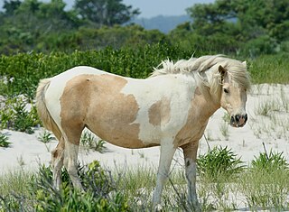
The Chincoteague pony, also known as the Assateague horse, is a breed of horse that developed and lives in a feral condition on Assateague Island in the states of Virginia and Maryland in the United States. The breed was made famous by the Misty of Chincoteague series of novels written by Marguerite Henry starting in 1947. While phenotypically horse-like, they are commonly called "ponies". This is due in part to their smaller stature, created by the poor habitat on Assateague Island. Variation is found in their physical characteristics due to blood from different breeds being introduced at various points in their history. They can be any solid color and are often found in pinto patterns, which are a favorite with breed enthusiasts. Island Chincoteagues live on a diet of salt marsh plants and brush. This poor-quality and often scarce food combined with uncontrolled inbreeding created a propensity for conformation faults in the Chincoteague before outside blood was added beginning in the early 20th century.

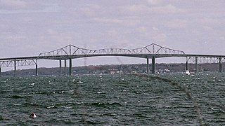
Assateague State Park is a public recreation area in Worcester County, Maryland, USA,, located at the north end of Assateague Island, a barrier island bordered by the Atlantic Ocean on the east and Sinepuxent Bay on the west. The state park is bordered on both its north and south sides by Assateague Island National Seashore and is reached via the Verrazano Bridge which carries Maryland Route 611 across Sinepuxent Bay. The park offers wildlife viewing, beach activities, and camping facilities. It is managed by the Maryland Park Service of the larger Maryland Department of Natural Resources with the support of volunteers working under the auspices of the non-profit Friends of Assateague State Park.

Sinepuxent Bay is an inland waterway which connects Chincoteague Bay to Isle of Wight Bay, and is connected to the Atlantic Ocean via the Ocean City Inlet. It separates Sinepuxent Neck, in Worcester County, Maryland from Assateague Island, and West Ocean City, Maryland from downtown Ocean City. Islands in the Sinepuxent Bay include Horn Island and Skimmer Island. It is crossed by the Harry W. Kelley Memorial Bridge on U.S. Route 50 and the Verrazano Bridge on Maryland Route 611. The bay is the location of the islands that compose the Sinepuxent Bay Wildlife Management Area. Historically the area was referred to by various names including Sinepuxent, Sene Puxon, Synepuxent, Cinnepuxon, et al.

State Route 175 (SR 175) is a primary state highway in the U.S. state of Virginia. Known as Chincoteague Road, the state highway runs 10.49 miles (16.88 km) from U.S. Route 13 (US 13) at Nash Corner east to Main Street in Chincoteague. SR 175 passes through the northeastern corner of Accomack County, providing the primary access to NASA's Wallops Flight Facility and both Chincoteague Island and the Virginia portion of Assateague Island. The route travels between the mainland and Chincoteague Island along the John B. Whealton Memorial Causeway.

Maryland Route 611 is a state highway in the U.S. state of Maryland. Known as Stephen Decatur Highway, the state highway runs 8.51 miles (13.70 km) from Assateague Island north to U.S. Route 50 in West Ocean City. MD 611 is named for Stephen Decatur, the U.S. naval officer of the early 19th century who was born in nearby Berlin. The state highway provides access to Assateague State Park and Assateague Island National Seashore via the Verrazano Bridge named for Giovanni da Verrazzano. MD 611 was first paved in West Ocean City in the mid-1930s. The highway was extended south to MD 376 at Lewis Corner in the 1940s. A ferry crossed Sinepuxent Bay to Assateague Island from the southern end of the county highway that continued south from Lewis Corner until MD 611 was extended across the Verrazano Bridge in the mid-1960s.

Maryland Route 376 is a state highway in the U.S. state of Maryland. Known for most of its length as Assateague Road, the state highway runs 4.56 miles (7.34 km) from MD 818 in Berlin east to MD 611 at Lewis Corner. MD 376 connects Berlin with communities on the Sinepuxent Neck and, in conjunction with MD 611, connects Berlin with Assateague Island National Seashore. The state highway was constructed from Berlin in the second half of the 1920s and the early 1930s.
The Maryland highway system is a network of highways owned and maintained by the U.S. state of Maryland. In addition to the nationally numbered Interstate Highways and U.S. Highways, the highway system consists of a network of Maryland state-numbered highways. All three types of highways together provide access to all incorporated and unincorporated areas in all 23 counties of Maryland as well as the independent city of Baltimore.

Fenwick Island is a barrier island along the Atlantic Ocean in Delaware and Maryland in the United States. It contains the communities of South Bethany and Fenwick Island in Delaware along with Ocean City, Maryland. Until 1933, it was attached to Assateague Island to the south. That year, a hurricane carved an inlet between the two landforms, which was made permanent. If not for the Assawoman Canal, constructed by the U.S. Army Corps of Engineers in 1891, the island would be attached to the mainland of Delaware.

The Virginia Barrier Islands are a continuous chain of long, narrow, low-lying, sand and scrub barrier islands separated from one another by narrow inlets and from the mainland by a series of shallow marshy tidal bays along the entire coast of the Virginia end of the Delmarva Peninsula. Several of these islands were once significantly larger, covered with pine forests, and inhabited. After the completion of the New York, Philadelphia and Norfolk Railroad in the late 19th Century, at least five lavish hunting and fishing clubs were established on Virginia's barrier islands and they became a playground for wealthy sportsmen from Northeastern cities who would arrive by train. US President Grover Cleveland visited Hog Island to hunt waterfowl and go fishing in the early 1890s.
Ilia Fehrer was an environmentalist and member of the Maryland Women's Hall of Fame most widely known for fighting to preserve Assateague Island, Chincoteague Bay, and other Chesapeake Bay coastal regions from destructive urban development.

