
Lake Chad is a historically large, shallow, endorheic lake in Central Africa, which has varied in size over the centuries. According to the Global Resource Information Database of the United Nations Environment Programme, it shrank by as much as 95% from about 1963 to 1998. The lowest area was in 1986, at 279 km2 (108 sq mi), but "the 2007 (satellite) image shows significant improvement over previous years." Lake Chad is economically important, providing water to more than 30 million people living in the four countries surrounding it on the central part of the Sahel. It is the largest lake in the Chad Basin.

The Ural, known before 1775 as Yaik, is a river flowing through Russia and Kazakhstan in the continental border between Europe and Asia. It originates in the southern Ural Mountains and discharges into the Caspian Sea. At 2,428 kilometres (1,509 mi), it is the third-longest river in Europe after the Volga and the Danube, and the 18th-longest river in Asia. The Ural is conventionally considered part of the boundary between the continents of Europe and Asia.

Rutland Water is a reservoir in Rutland, England, east of Rutland's county town, Oakham. It is filled by pumping from the River Nene and River Welland, and provides water to the East Midlands. By surface area it is the largest reservoir in England, but its capacity is exceeded by that of Kielder Water in Northumberland. Its maximum depth is 33m.

Lake Naivasha is a freshwater lake in Kenya, outside the town of Naivasha in Nakuru County, which lies north west of Nairobi. It is part of the Great Rift Valley. The name derives from the local Maasai name ɛnaɨpɔ́sha , meaning "that which heaves," a common Maasai word for bodies of water larger enough to have wave action when it is windy or stormy. Naivasha arose as the British attempt to pronounce the Maasai name. Literally, Lake Naivasha means "Lake Lake."

The Seversky Donets or Siverskyi Donets, usually simply called the Donets, is a river on the south of the East European Plain. It originates in the Central Russian Upland, north of Belgorod, flows south-east through Ukraine and then again through Russia to join the river Don, about 100 km (62 mi) from the Sea of Azov. The Donets is the fourth-longest river in Ukraine, and the largest in eastern Ukraine, where it is an important source of fresh water. It gives its name to the Donets Basin, known commonly as the Donbas, an important coal-mining and industrial region in Ukraine.

Étang Saumâtre is the largest lake in Haiti and the second largest lake in the Dominican Republic and Hispaniola, after Lake Enriquillo. It is also known as Lake Azuéi ; its Taíno name was Yainagua.

Lake Argyle is Western Australia's largest and Australia's second largest freshwater man-made reservoir by volume. The reservoir is part of the Ord River Irrigation Scheme and is located near the East Kimberley town of Kununurra. The lake flooded large parts of the Shire of Wyndham-East Kimberley on the Kimberley Plateau about 80 kilometres (50 mi) inland from the Joseph Bonaparte Gulf, close to the border with the Northern Territory.
Lake Corangamite, a hypersaline endorheic lake, is located near Colac in the Lakes and Craters region of the Victorian Volcanic Plains of south-west Victoria, Australia. The lake's salinity levels have increased dramatically as the lake level has dropped in recent decades. It is Australia's largest permanent saline lake, covering approximately 230 square kilometres (89 sq mi) with a circumference of 150 kilometres (93 mi). It forms part of the Ramsar-listed Western District Lakes wetland site. The Aboriginal name of the lake is recorded as Kronimite.

West Water Reservoir is an artificial reservoir in the Pentland Hills, Scottish Borders, 3 kilometres (1.9 mi) west of West Linton, and 26 kilometres (16 mi) south west of Edinburgh. It is a drinking water reservoir for Edinburgh and the Lothians and is located 320 metres (1,050 ft) above sea level. It is an important site for wildfowl and is designated as a SSSI and a Ramsar site.

The Rokel River is the largest river in the Republic of Sierra Leone in West Africa. The river basin measures 10,622 square kilometres (4,101 sq mi) in size, with the drainage divided by the Gbengbe and Kabala hills and the Sula Mountains. The estuary which extends over an area of 2,950 square kilometres (1,140 sq mi) became a Ramsar wetland site of importance in 1999.

Maharana Pratap Sagar, also known as Pong Reservoir or Pong Dam Lake is a large reservoir in Fatehpur, Jawali and Dehra tehsil of Kangra district of the state of Himachal Pradesh in India. It was created in 1975, by building the highest earthfill dam in India on the Beas River in the wetland zone of the Siwalik Hills. Named in the honour of Maharana Pratap (1540–1597), the reservoir or the lake is a well-known wildlife sanctuary and one of the 49 international wetland sites declared in India by the Ramsar Convention. The reservoir covers an area of 24,529 hectares, and the wetlands portion is 15,662 hectares.

Aguelmame Sidi Ali is a lake in Khénifra Province, Béni Mellal-Khénifra, Morocco. Located at an altitude of 2,080 metres, Aguelmame Sidi Ali has a surface area of approximately 500 hectares and a depth of 36 m (118 ft). It is near the boundary of the province of Ifrane within the Middle Atlas mountains. It is part of Khenifra National Park, a 842 km2 (325 sq mi) protected area created in 2008.

The Blue Lake is one of only four cirque lakes found in mainland Australia. The other three, Cootapatamba, Albina, and Club, are shallower and are held entirely by terminal moraines. Blue Lake's valley contains the best-developed glacial features in the Kosciuszko National Park alpine area of New South Wales. It was recognised as a wetland of international importance on 17 March 1996 when a 320-hectare (790-acre) area, comprising the lake and its surrounds, including nearby Hedley Tarn, was designated Ramsar Site 800 under the Ramsar Convention on wetlands. The lake lies within the Australian Alps National Parks and Reserves.
Dniprovsko Orilskyi Nature Reserve is a strict nature reserve of Ukraine located in the center of the country in the valley of the Dnieper River. Administratively, the reserve is located in Dnipro Raion of Dnipropetrovsk Oblast, Ukraine.

Meshchyorsky National Park covers extensive wetlands and pine/birch woodlands in the Meshchera Lowlands on the East European Plain in the northern section of Ryazan Oblast, Russia, about 120 km east of Moscow. The wetland habitat provides for extremely rich biodiversity among the plants and animals. "Meshchersky" (Мещёрский) National Park is not to be confused with "Meshchyora" (Мещёра) National Park, which is just to the north, over the border in Vladimir Oblast. The park protects a section of the Pra River, Lake Beloye, and associated wetlands and forests. About 54% of the park territory is used and managed for agricultural purposes by local communities.

Rostov Nature Reserve is a Russian 'zapovednik' that protects a variety of sensitive southern European steppe wetlands, the largest herd of wild horses in Europe, and also wetland habitat for birds. The protected areas are divided into five sections that cover the waters of Lake Manych-Gudilo, islands in that lake, surrounding steppe and shore lands. The reserve is situated in the Orlovsky District, of Rostov Oblast, about 100 km northeast of Rostov-on-Don. It is part of a Ramsar Wetland site of international importance.
Malala-Ambilikala Lagoons are two interconnected coastal water-bodies located inside the Bundala National Park, Hambantota District in the Southern Province, Sri Lanka. It is 260 km (160 mi) from Colombo to the arid south. The Malala-Ambilikala Lagoons are two of the three key lagoons located within the Bundala Ramsar wetlands.

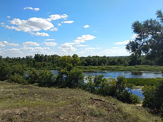
Great Meadow National Nature Park covers historic steppe terrain in southeast Ukraine. It is on the south bank of the Dnieper River's Kakhovka Reservoir, which was created by the Dnieper Hydroelectric Station. The meadows and reed beds on the shore support one of the largest transmigration spots for birds in Eastern Europe. The park is in the administrative district of Vasylivka Raion in Zaporizhzhia Oblast.

The Saharan halophytics ecoregion covers a series of low-lying evaporite depressions and wetlands spread across North Africa. The depressions are characteristically saline, variously chotts or sabkhas. The plants of the areas are highly specialized to survive in the harsh environment, with many being xerophytes (drought-tolerant) and halophytes (salt-tolerant). The biodiversity of the areas has been relatively protected by their isolation, and unsuitability of alkaline soil for farming.
Lake Letsie is a reservoir in the Drakensberg mountains in Quthing District, Lesotho. The reservoir was formed when a smaller, natural lake was enlarged by damming the source of the Mohlakeng River in 1968. The lake and the wetlands surrounding the shore have been designated as a national protected area since 2001 and a Ramsar site since 2004.

