
Cape Girardeau Regional Airport is a city owned public use airport in Scott County, Missouri, United States. It is located five nautical miles southwest of the central business district of Cape Girardeau, a city in Cape Girardeau County, Missouri, United States. The airport is used for general aviation, and has scheduled service by Contour Airlines with subsidized Essential Air Service program flights to Nashville.

Waynesville-St. Robert Regional Airport, also known as Forney Field, is a public and military use airport located at Fort Leonard Wood in Pulaski County, Missouri, United States. The airport's passenger terminal is operated under the control of the U.S. Army and general aviation is under the direction of a board named by the cities of Waynesville and St. Robert. Formerly known as Waynesville Regional Airport at Forney Field, it is served by one commercial airline with scheduled service subsidized by the Essential Air Service program.

Southeast Iowa Regional Airport is a public airport located two miles southwest of Burlington, in Des Moines County, Iowa. It is owned by the Southeast Iowa Regional Airport Authority which includes representatives from the city of Burlington, the city of West Burlington, and Des Moines County. The airport is used for general aviation and sees one airline, a service subsidized by the federal government's Essential Air Service program at a cost of $1,917,566.

Rutland–Southern Vermont Regional Airport, is a state-owned, public use airport located five nautical miles south of the central business district of Rutland, a city in Rutland County, Vermont, United States. Situated in North Clarendon, it was formerly known as Rutland State Airport. Scheduled commercial service is subsidized by the Essential Air Service and provided by Cape Air, with three flights daily on eleven-passenger Tecnam P2012 Traveller aircraft to Boston with typical flight times of 40 minutes.

Lancaster Airport is a public use airport four nautical miles north of the central business district of Lancaster, in Lancaster County, Pennsylvania, United States. It is owned by the Lancaster Airport Authority. It is served by one commuter airline subsidized by the Essential Air Service program and one charter airline.

Wrangell Airport is a state-owned public-use airport located one nautical mile (2 km) northeast of the central business district of Wrangell, a city and borough in the U.S. state of Alaska which has no road access to the outside world. Scheduled airline service is subsidized by the Essential Air Service program.
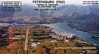
Petersburg James A. Johnson Airport is a state owned, public use airport located one nautical mile (2 km) southeast of the central business district of Petersburg, a city in the Petersburg Borough of the U.S. state of Alaska that has no road access to the outside world. Airline service is subsidized by the Essential Air Service program.

Yakutat Airport is a state-owned public-use airport located three nautical miles (6 km) southeast of the central business district of Yakutat, a city and borough in the U.S. state of Alaska which has no road access to the outside world. Airline service is subsidized by the Essential Air Service program.

Merle K. (Mudhole) Smith Airport is a state-owned public-use airport located 11 nautical miles southeast of the central business district of Cordova, a city in the Chugach Census Area of the U.S. state of Alaska which has no road access to the outside world. Airline service is subsidized by the Essential Air Service program.
Dawson Community Airport is five miles northwest of Glendive, in Dawson County, Montana, United States. The airport has one airline, subsidized by the Essential Air Service program.
Havre City–County Airport is a public use airport located three nautical miles (6 km) west of the central business district of Havre, a city in Hill County, Montana, United States. It is owned by the City of Havre and Hill County. The airport is served by one commercial airline, subsidized by the Essential Air Service program. Per the Bureau of Statistics Havre was the least used airport in the Continental United States flying around 5000 passengers in the year ending 2022.
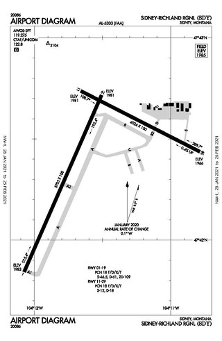
Sidney–Richland Municipal Airport is a mile west of Sidney, in Richland County, Montana, United States. The airport is served by one airline, subsidized by the federal government's Essential Air Service program at a cost of $3,777,579.
L. M. Clayton Airport is a public airport three miles east of Wolf Point, in Roosevelt County, Montana, United States. The airport is served by one airline, subsidized by the Essential Air Service program. Reportedly, it is the smallest airport in the 48 contiguous states with scheduled air service.

Quincy Regional Airport is a city-owned airport 12 miles east of Quincy, a city in Adams County, Illinois, United States. It is used for general aviation but also sees Southern Airways Express flights to Chicago's O'Hare International Airport and St. Louis Lambert International Airport, a service which is subsidized by the federal government's Essential Air Service program at a cost of $1,956,856. The Federal Aviation Administration (FAA) National Plan of Integrated Airport Systems for 2023–2027 categorized it as a national non-primary commercial service facility.
McKellar–Sipes Regional Airport is a public use airport located four nautical miles (7 km) west of the central business district of Jackson, a city in Madison County, Tennessee, United States. It is owned by the city and county. The airport is mostly used for general aviation, and is served by one commercial airline, Southern Airways Express, subsidized by the Essential Air Service program.
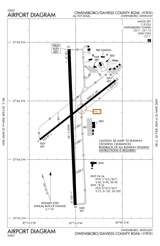
Owensboro–Daviess County Airport is a public use airport located three miles southwest of Owensboro, in Daviess County, Kentucky. The airport is owned by both the city and county. One airline schedules passenger flights, subsidized by the Essential Air Service program.

Massena International Airport is in St. Lawrence County, New York. It is two nautical miles (3.7 km) east of the village of Massena. The airport sees one airline, subsidized by the Essential Air Service program.

Ogdensburg International Airport is a public airport located in the town of Oswegatchie, 2 miles (3.2 km) southeast of Ogdensburg, in St. Lawrence County, New York. It is owned by the Ogdensburg Bridge & Port Authority, which also owns and operates the Ogdensburg–Prescott International Bridge, Port of Ogdensburg-Marine Terminal Facility, Commerce Park, Port of Waddington, a medium-heavy industrial park and two short line railroads. The Ogdensburg Bridge and Port Authority is a New York State public-benefit corporation. The international airport is just outside the city limits on NY 812. It is used for general aviation and commercial service. Scheduled commercial flights are operated by one airline: Contour Airlines.

Decatur Airport is a public airport five miles east of Decatur, in Macon County, Illinois, United States. The airport is owned by the Decatur Park District. Airline service is subsidized by the federal government's Essential Air Service program at a cost of $2,667,922.

Gustavus Airport is a state-owned public-use airport located in Gustavus, a city in the Hoonah-Angoon Census Area of the U.S. state of Alaska. Scheduled airline service is subsidized by the Essential Air Service program.


