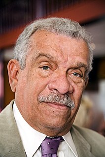
Sir Derek Alton Walcott was a Saint Lucian poet and playwright. He received the 1992 Nobel Prize in Literature. His works include the Homeric epic poem Omeros (1990), which many critics view "as Walcott's major achievement." In addition to winning the Nobel Prize, Walcott received many literary awards over the course of his career, including an Obie Award in 1971 for his play Dream on Monkey Mountain, a MacArthur Foundation "genius" award, a Royal Society of Literature Award, the Queen's Medal for Poetry, the inaugural OCM Bocas Prize for Caribbean Literature, the 2010 T. S. Eliot Prize for his book of poetry White Egrets and the Griffin Trust For Excellence in Poetry Lifetime Recognition Award in 2015.

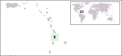
Saint Lucia is an island country in the West Indies in the eastern Caribbean Sea on the boundary with the Atlantic Ocean. The island was previously called Iyonola, the name given to the island by the native Arawaks, and later Hewanorra, the name given by the native Caribs, two separate Amerindian peoples. Part of the Windward Islands of the Lesser Antilles, it is located north/northeast of the island of Saint Vincent, northwest of Barbados and south of Martinique. It covers a land area of 617 km2 and reported a population of 165,595 in the 2010 census. St. Lucia's largest city is Castries, its current capital, and its second largest is Soufrière, the first French colonial capital on the island.

Saint Lucia was inhabited by the Arawak and Kalinago Caribs before European contact in the early 16th century. It was colonized by the British and French in the 17th century and was the subject of several possession changes until 1814, when it was ceded to the British by France for the final time. In 1958, St. Lucia joined the short-lived semi-autonomous West Indies Federation. Saint Lucia was an associated state of the United Kingdom from 1967 to 1979 and then gained full independence on February 22, 1979.

Castries is the capital and largest city of Saint Lucia, an island country in the Caribbean. The urban area had the population of approximately 20,000, while the eponymous district had a population of 70,000 on 22 May 2013. The city stretches over an area of 80 km2 (31 sq mi).
The flag of Saint Lucia consists of a cerulean blue field charged with a yellow triangle in front of a white-edged black isosceles triangle. Adopted in 1967 to replace the British Blue Ensign defaced with the arms of the colony, it has been the flag of Saint Lucia since the country became an associated state of the United Kingdom that year. Although the overall design of the flag has remained unchanged, specific aspects of it have been altered over the years.
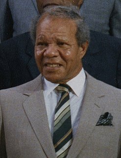
Sir John George Melvin Compton, was a Saint Lucian politician who became the first Prime Minister upon independence in February 1979. Having led Saint Lucia under British rule from 1964 to 1979, Compton served as Prime Minister three times: briefly in 1979, again from 1982 to 1996, and from 2006 until his death in 2007. He cofounded the conservative United Workers Party (UWP) in 1964; he led the party until 1996, then again from 2005 to 2007.

Vieux Fort is one of 10 districts of the Caribbean island nation of Saint Lucia. Vieux Fort is also the name of the main town in the district. It is the home of the second-largest town in Saint Lucia and is the home of Saint Lucia's international airport, Hewanorra International Airport.

The University of the West Indies (UWI), originally University College of the West Indies, is a public university system established to serve the higher education needs of the residents of 17 English-speaking countries and territories in the Caribbean: Anguilla, Antigua and Barbuda, The Bahamas, Barbados, Belize, Bermuda, British Virgin Islands, Cayman Islands, Dominica, Grenada, Guyana, Jamaica, Montserrat, St. Kitts and Nevis, St. Lucia, St. Vincent and the Grenadines, Trinidad and Tobago, and Turks and Caicos Islands. Each country is either a member of the Commonwealth of Nations or a British Overseas Territory. The aim of the university is to help "unlock the potential for economic and cultural growth" in the West Indies, thus allowing improved regional autonomy. The university was originally instituted as an independent external college of the University of London.
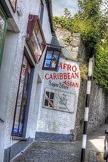
Afro-Caribbean people or African Caribbean are Caribbean people who trace their full or partial ancestry to Africa. The majority of the modern African-Caribbeans descend from Africans taken as slaves to colonial Caribbean via the trans-Atlantic slave trade between the 15th and 19th centuries to work primarily on various sugar plantations and in domestic households. Other names for the ethnic group include Black Caribbean, Afro or Black West Indian or Afro or Black Antillean. The term Afro-Caribbean was not coined by Caribbean people themselves but was first used by European Americans in the late 1960s.

Tropical Storm Debby was a weak but costly tropical cyclone that affected the Lesser Antilles in September 1994. It was the fourth named tropical storm of the 1994 Atlantic hurricane season; it developed on September 9 east of Barbados. Debby made landfall on Saint Lucia early on September 10, producing heavy rainfall and tropical storm-force wind gusts. The rains caused flooding and landslides, damaging about half of the island's banana plantations. Several villages were isolated after roads and bridges were damaged. Damage totaled about $103 million (1994 USD). On nearby Dominica, Debby damaged crops and fisheries.
The Southern Caribbean is a group of islands that neighbor mainland South America in the West Indies. Saint Lucia lies to the north of the region, Barbados in the east, Trinidad and Tobago at its southernmost point, and Aruba at the most westerly section.

The effects of Hurricane Dean in the Lesser Antilles were spread over five island countries and included 3 fatalities. Hurricane Dean of the 2007 Atlantic hurricane season formed in the Atlantic Ocean west of Cape Verde on August 14, 2007. The National Hurricane Center's first Forecast Advisory on the system anticipated that the Cape Verde-type hurricane would pass into the Caribbean through the Lesser Antilles. The storm moved persistently towards the small island chain, strengthening until it passed through the islands three days later on August 17 as a Category 2 hurricane on the Saffir-Simpson Hurricane Scale. It went on to brush the island of Jamaica and reached Category 5 strength before making landfall on Mexico's Yucatán Peninsula.
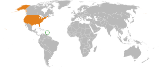
Saint Lucia – United States relations are bilateral relations between Saint Lucia and the United States. Linda Swartz Taglialatela is the U.S. Ambassador to St. Lucia.

The Caribbean is a region of the Americas that consists of the Caribbean Sea, its islands and the surrounding coasts. The region is southeast of the Gulf of Mexico and the North American mainland, east of Central America, and north of South America islets, reefs and cays. Island arcs delineate the eastern and northern edges of the Caribbean Sea: The Greater Antilles and the Lucayan Archipelago on the north and the Lesser Antilles and the on the south and east. They form the West Indies with the nearby Lucayan Archipelago, which are considered to be part of the Caribbean despite not bordering the Caribbean Sea. On the mainland, Belize, Nicaragua, the Caribbean region of Colombia, Cozumel, the Yucatán Peninsula, Margarita Island, and the Guianas are often included due to their political and cultural ties with the region.
The following is an alphabetical list of topics related to the nation of Saint Lucia.
Vieux Fort is a town located near the southernmost point of Saint Lucia, a Caribbean island nation. It is named after a fort that used to watch out towards Saint Vincent towards the south. The population of the town was 4,574 in 2010, while the surrounding district of Vieux Fort has a total population of about 15,132 in 2010.
Total expenditure on health in Saint Lucia was 6.72% of the GDP in 2014. Health expenditure was at US$302 per capita in 2004. Infant mortality was at 12 per 100,000 births in 2005.
Indo–Saint Lucians or Indian–Saint Lucians, are Saint Lucians whose ancestry lies within the country of India, primarily the modern-day Indian states of Bihar, Jharkhand and Uttar Pradesh in Northern India. In 1859, the British began transporting indentured workers from British India to work on plantation estates in Saint Lucia, which had become a British colony in 1814. The first ship carrying 318 indentured workers from India, the Palmyra, arrived in Saint Lucia on 6 May 1859, and the last ship carrying Indian indentured workers, the Volga, arrived on 10 December 1893.

Sister Mary Irma Hilger was an American religious sister, who trained as a nurse and founded the St. Jude Hospital and nurse's training school on the Caribbean island of St. Lucia. She has been called the "Florence Nightingale of St. Lucia".

Mexico–Saint Lucia relations refers to the diplomatic relations between the United Mexican States and Saint Lucia. Both nations are members of the Association of Caribbean States, Organization of American States and the United Nations.
