
Arcot is a town and urban area of Ranipet district in the state of Tamil Nadu, India. Located on the southern banks of Palar River, the city straddles a trade route between Chennai and Bangalore or Salem, between the Mysore Ghat and the Javadi Hills. As of 2018, the city had a population 129,640. The sweet makkan peda is a local speciality while Arcot biryani, a rice-based traditional food, is also served here.
Mahoba is a city in Mahoba District of the Indian state of Uttar Pradesh in the Bundelkhand region, well known for the ninth century granite Sun temple built in Pratihara style. It is also well known for the 24 rock-cut Jain tirthankara image on Gokhar hill. Mahoba is known for its closeness to Khajuraho, Lavkushnagar and other historic places like Kulpahar, Charkhari, Kalinjar, Orchha, and Jhansi. The town is connected with railways and state highways.

Vandavasi is a major town and a municipality in the Tiruvannamalai district of the Indian state of Tamil Nadu. The town is well known in the Carnatic history for the Battle of Wandiwash. Vandavasi town is also the largest manufacturer of kora artefacts including mats, shawls and vessels. As of 2011, the town had a population 74,320.
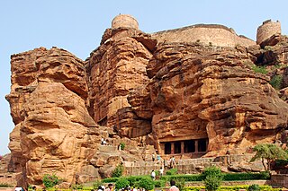
Badami, formerly known as Vātāpi, is a town and headquarters of a taluk by the same name, in the Bagalkot district of Karnataka, India. It was the regal capital of the Badami Chalukyas from 540 to 757. It is famous for its rock cut monuments such as the Badami cave temples, as well as the structural temples such as the Bhutanatha temples, Badami Shivalaya and Jambulingesvara Temple. It is located in a ravine at the foot of a rugged, red sandstone outcrop that surrounds Agastya lake.

Walajapet is a town or first municipality of Tamil Nadu and a part of Ranipet district, Vellore Metropolitan Area, in the state of Tamil Nadu. The streets in the town form a square shape which is a unique feature of the town. It will be easy for you to reach any part of the town with this kind of infrastructure. The streets are wide and nicely structured. As of 2024, the town had a population of 64,000.
Ranipettai is a town in Tamil Nadu, India and the headquarters of Ranipet district. Ranipet is an industrial hub of greater Vellore city. It is located about 100 kilometres (62 mi) from the Chennai city center. It is a major industrial town located on NH 4 Chennai-Bangalore highway, on the northern bank of the Palar River.The estimated population is 397,000 as of 2024.

Sholinghur is a municipality under Sholinghur taluk in Ranipet District of Tamil Nadu, India. The town is famous in Tamil Nadu and other neighboring states for the Lakshmi Narasimha Swamy temple.
Ammoor is a town panchayat in Ranipet district and it is part of Ranipet metropolitan area in the state of Tamil Nadu, India.
Ganapathipuram is a panchayat town in Kanniyakumari district in the state of Tamil Nadu, India.
Kalavai is a panchayat town in Ranipet district in the Indian state of Tamil Nadu. The main occupation represented in the area is farming. The town has a pond and a lake after rainy season. Villagers use the lake water and palar river for irrigation. Corporation Bank, State Bank Of India and Indian Bank are the banks that have branches in the locality. The secondary occupation is garment outlets. One government higher secondary school is also located in a nearby village.
Kalugumalai is a panchayat town in Kovilpatti Taluk of Thoothukudi district in the Indian state of Tamil Nadu. Kalugumalai is 21 km and 22 km from Kovilpatti and Sankarankovil respectively. The place houses the rockcut Kalugasalamoorthy Temple, monolithic Vettuvan Koil and Kalugumalai Jain Beds.
Kaveripakkam is a town panchayat in Ranipet district in the Indian state of Tamil Nadu.
Melvisharam is a town in Ranipet district of the Indian state of Tamil Nadu. It is 7 kilometres from Ranipet, 5 km from historic town of Arcot and 17 km from Vellore city.

Polur is a scenic town and a Religious site for Lord Narasimha called Sampathgiri, divisional headquarters and a market center in Tiruvannamalai district of Tamil Nadu in India. Located at the foothills of Javvadhi hills, a popular section of Eastern Ghats, Polur is often regarded as Gateway of Eastern ghats. Polur was once an eminent center of Tamil Jainism. The town is home to Dharani sugars, chemicals and fertiliser Pvt., Ltd, and number of agro based industries including coir industries. The famous Chittor - Cuddalore road passes through the town. The town is located 29 Kilometres north of city of Tiruvannamalai and 45 kilometres south of Vellore Metropolis.

Ramtek is a city and municipal council in Nagpur district of Maharashtra, India.

Talaja is a town and a municipality in Bhavnagar district in the Indian state of Gujarat.

Thiruparankundram, also spelled Tirupparankundram or Tiruparangundram, is a neighbourhood in Madurai city in Tamil Nadu, India. It is about 7 kilometres (4.3 mi) from Periyar Bus Terminus, the centre of the city and constitutes the southwest part of the Madurai city. The town's landmark and fame is the huge monolithic rock hill that towers to a height of 1,048 feet (319 m) and has a circumference of over 2 miles (3.2 km). It is a home to many ancient and historic monuments including Jain caves, some protected as India's national monuments.
Thimiri is a panchayat town in Ranipet district in the Indian state of Tamil Nadu.The Town Panchayat was originally a religious centre with the presence of large number of temples, Mosque. The town has gained importance especially by the cultivation of paddy, Ragi. Ground nut and Sugar Cane.The Somanatha Pashana Lingeswarar Temple a Hindu temple dedicated to Lord Shiva and Kumaragiri Murugan Temple is a Hindu Temple dedicated to Lord Murugan located in Kumaragiri Hills are famous temple in Timiri. The present the area of the Town Panchayat is 6.47 km2. The town is divided into 15 election wards. Thimiri is a Town Panchayat coming under the administrative territory of Ranipet district and Arcot Taulk. This Town is located on 22 km away from Arani, 31 km at away from Vellore city and 125 km away from State capital Chennai. Thimiri is on State Highway 4 or SH4 between Arcot and Arani. This is on the main route from Arani to Chennai Highway. The State Roads connect Thimiri Town Panchayat with surrounding towns and other urban centers in the district.
Valasaravakkam is a neighbourhood in the Chennai district of the Indian state of Tamil Nadu and a residential suburb of the city of Chennai. It is located in the Maduravoyal Taluk at a distance of approximately 15 kilometres from the Kilometer Zero stone. Valasaravakkam lies on the Arcot Road, one of Chennai's arterial roads. It is under the Maduravoyal election constituency. In October, 2011 Valasaravakkam Municipality ceased to exist and the area became part of Chennai Corporation as Ward Nos 149 and 152, Southern Region, Corporation of Chennai. As of 2011, the town had a population of 47,378. Famous Sivan temple is in Kesavardhini.

Tiruvannamalai district is the second largest district in Tamil Nadu by area after Dindigul District and one of the 38 districts in the state of Tamil Nadu, in South India. It was formed in the year 1989 through the bifurcation of North Arcot into the Tiruvannamalai Sambuvarayar and Vellore Ambedkar districts. The city of Tiruvannamalai is the district headquarters.