Villa Clara Province

Last updated
Villa Clara Province
Villa Clara sign.jpg
Sign seen when entering the province.
Seal of Villa Clara.png
Villa Clara in Cuba.svg
Country Cuba
Capital Santa Clara
Government
  Governor Alberto López Díaz
  Vice-GovernorMilaxy Yanet Sánchez Armas
Area
[1]
  Total8,413.13 km2 (3,248.33 sq mi)
Population
 (2010-12-31) [1]
  Total803,562
  Density96/km2 (250/sq mi)
Time zone UTC-5 (EST)
HDI (2019)0.768 [2]
high · 11th of 16
Website https://www.soyvillaclara.gob.cu/es/

Villa Clara is one of the provinces of Cuba. It is located in the central region of the island bordering on the Atlantic Ocean to the north, Matanzas Province to the west, Sancti Spiritus Province to the east, and Cienfuegos Province to the South. Villa Clara shares with Cienfuegos and Sancti Spiritus on the south the Escambray Mountain Range. Its main cities are Santa Clara (the capital), Remedios, Sagua La Grande, Camajuani, Caibarién, Ranchuelo, Placetas, and Manicaragua.

Contents

History

Vidal Park in Santa Clara 5 Vidal-Santa-Clara.jpg
Vidal Park in Santa Clara

Prior to 1976, the current provinces of Cienfuegos, Sancti Spíritus, and Villa Clara were all part of the now obsolete province of Las Villas, but Villa Clara is still referred some times just as "Las Villas" using the shorter old name. Santa Clara was the capital of historical Las Villas and still capital of Villa Clara province. That old name itself, Spanish for "The Cities", refers to the four original 16th and 17th-century cities founded in this vast territory: San Juan de los Remedios, Sancti Spíritus, Santísima Trinidad and Gloriosa Santa Clara.

During pre-Spanish settlement in Cuba, what now is Villa Clara province was populated by Taíno people with chieftains of Sabanaque (north west), Sabana (north east), and Cubanacan, literally "The Middle Land" in the center where Santa Clara city is located nowadays. In this region from the eastern landing point of the Spanish was where Columbus believed the "King of India" was living.

In early colonial Cuba, historical province Las Villas was center to cattle industry but by the 18th and 19th centuries it had shifted to sugar production with a large concentration of mills. At the beginning of the 20th century it had the highest percentage of land farms (90%). [3] In 1950 it was second to Havana in manufacturing establishments.

After Castro's revolution in the 1960s it still led in sugar production on the island, but in the late 80s and 90s after the collapse of the Soviet Union and lack of support thereof, most of the already inefficient mills were closed down, some of them disassembled, while others became museums. Only the most efficient mills are still producing sugar. Since then the province concentrated its efforts on building beach resorts.

The country's first transgender municipal delegate was elected in Villa Clara in early 2013. Adela Agustin Hernandez is a resident of the town of Caibarien and works as a nurse electrocardiogram specialist. [4]

Economy

Sugarcane plantations in Villa Clara 9 Canaveral-Villa-Clara.jpg
Sugarcane plantations in Villa Clara

Sugar, the commodity that the Cuban economy once relied upon, was primarily based in the plains in the north of the province, and several large mills provided employment to many people. Now in the newly restructured Cuban economy, most of these mills have been abandoned and the economy is instead focused on newly built beach resorts in the north cays. Sugar and tobacco are still the two most important agricultural commodities of the province.[ citation needed ]

Geography

The northern coast of Villa Clara is dotted with numerous cays (part of the Sabana-Camaguey Archipelago), and there are many coral reefs, sandy beaches, and newly constructed touristic resorts.

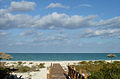
The Cays are a capricious cluster of some 500 islands, strewn along a sea of varying shades of blues and greens off the northern coast of the central province of Villa Clara and close to the second largest coral barrier reef in the world. It is a tropical paradise with more than 17 km of fine-white sand beaches.

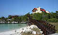
Villa Clara Cays, covering more than 77 844 hectares, are a veritable wildlife refuge and provide a habitat for some 248 species of plants. The most precious jewels are Cayo Las Brujas, Cayo Ensenachos and Cayo Santa Maria, renowned for their immaculate landscape of incredible beauty, with sugary-white sand beaches and crystal-clear waters, fringed by autochthonous vegetation and connected to Caibarien, a small fishing town on the Cuban mainland, by a 48 km causeway stretching over the sea -accorded an international prize for its harmonious combination of nature and engineering in an area declared a World Biosphere Reserve- thus enabling visitors to access the cays directly from Santa Clara City, site of the international airport. The causeway has a total of 46 bridges especially designed to allow the flow of sea water, therefore protecting both the biodiversity and sustainability of the area.

Escambray Mountains 11 Sierra Escambray VC.JPG
Escambray Mountains

There are smaller airfields near most of the main towns, plus a small international terminal in Cayo Las Brujas for the operation of small and medium size charter aircraft.

Villa Clara Cays, located approximately 300 km from Havana, are part of the Jardines del Rey archipelago, the largest archipelago surrounding Cuba which extends 465 km along the northern coast of the country.

A site of legends, it is said that this island, maze of singular biodiversity, was once a haven for pirates and buccaneers ready to pounce on ship passing along Cuba's shores.

Cayo Las Brujas takes its name from an old legend about a young couple whose love was thwarted by a jealous uncle, who in turn is the namesake of another islet: Cayo Borracho, which means drunkard. The remains of the San Pascual, a ship that ran aground many years ago, can be observed a mile away from the cay. Built in San Francisco, California and launched in 1919, the ship evokes the presence of American writer Ernest Hemingway in the area. From its deck, Cuban painter Leopoldo Romañach found inspiration for some of his famous marine landscapes.

Cayo Ensenachos is the smallest of the three cays but is a refuge for 22 endemic plants and 39 wildlife species. Shaped like a horseshoe, the islet was originally an aboriginal settlement. The beach is always calm due to the position of the cay which prevents the large waves from hitting the shore with force.

Cayo Santa María is also known as the White Rose of Jardines del Rey. The cay was named after the flagship of Christopher Columbus's fleet on his maiden voyage to the New World. Legend has it that this strip of land -some 13 km long and 2 km in width - is said to be haunted by the spirit of Rosa Maria Coraje, a woman who hid aboard a ship in a desperate attempt to find both paradise and her beloved. She landed on the cay and managed to survive hiding in the marshes, among the mangroves and feeding on fish, until she finally discovered her dearly-loved in a neighboring cay.

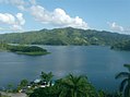
Around Santa Clara, the land rises into the Alturas de Santa Clara. The highest point in the Santa Clara region is in the Alturas, at 464 m (1,522 ft) above sea level, while the south, dominated by the Escambray Mountains, reach elevations of over 900 m (3,000 ft). Villa Clara also has numerous lakes, which are used for both water sports and fishing. The largest Cuban river to drain into the Atlantic, Río Sagua la Grande, is also in Villa Clara province.

Municipalities

Municipality Population
(2022)
Area
(km2)
LocationImage
Caibarién 40,798212 22°30′57″N79°28′20″W / 22.51583°N 79.47222°W / 22.51583; -79.47222 (Caibarién)
_ 5 Caibarienmusee.jpg
_
Camajuaní 57,142614 22°28′5″N79°43′25″W / 22.46806°N 79.72361°W / 22.46806; -79.72361 (Camajuaní)
_ BoulevardCamajuani.JPG
_
Cifuentes 26,135512 22°37′15″N80°03′57″W / 22.62083°N 80.06583°W / 22.62083; -80.06583 (Cifuentes)
Corralillo 24,791843 22°59′9″N80°34′58″W / 22.98583°N 80.58278°W / 22.98583; -80.58278 (Corralillo)
Encrucijada 31,500345 22°37′2″N79°51′58″W / 22.61722°N 79.86611°W / 22.61722; -79.86611 (Encrucijada)
Manicaragua 61,4451,063 22°09′1″N79°58′34″W / 22.15028°N 79.97611°W / 22.15028; -79.97611 (Manicaragua) Parque Manicaragua e iglesia.jpg
Placetas 65,379601 22°18′58″N79°39′19″W / 22.31611°N 79.65528°W / 22.31611; -79.65528 (Placetas)
_ Placetas.jpg
_
Quemado de Güines 20,533338 22°47′24″N80°15′21″W / 22.79000°N 80.25583°W / 22.79000; -80.25583 (Quemado de Güines)
Ranchuelo 50,708556 22°20′10″N80°06′46″W / 22.33611°N 80.11278°W / 22.33611; -80.11278 (Ranchuelo) Ranchuelo Ayuntamiento.jpg
Remedios 42,134560 22°29′32″N79°32′44″W / 22.49222°N 79.54556°W / 22.49222; -79.54556 (Remedios)
Oldest city of Villa Clara province, established in 1513 RemediosChurch.jpg
Oldest city of Villa Clara province, established in 1513
Sagua la Grande 49,986661 22°48′32″N80°04′15″W / 22.80889°N 80.07083°W / 22.80889; -80.07083 (Sagua la Grande)
_ SaguaLaGrande.jpg
_
Santa Clara 245,959514 22°24′20″N79°57′14″W / 22.40556°N 79.95389°W / 22.40556; -79.95389 (Santa Clara)
Provincial capital Calle Parque SC.JPG
Provincial capital
Santo Domingo 46,984883 22°35′1″N80°14′18″W / 22.58361°N 80.23833°W / 22.58361; -80.23833 (Santo Domingo)
- CCStoDomingo.JPG
-
Source: Estimate from 2022. [5] Area from 1976 municipal re-distribution. [6]

Demographics

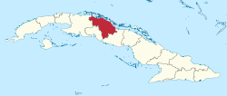
In 2004, the province of Villa Clara had a population of 817,070. [7] With a total area of 8,412.41 km2 (3,248.05 sq mi), [8] the province had a population density of 97.1/km2 (251/sq mi).

Notable residents

See also

Related Research Articles

<span class="mw-page-title-main">Placetas</span> Municipality in Villa Clara, Cuba

Placetas is a city in the Villa Clara Province in the center of Cuba; before the change in the country's government in 1959 the province was called Las Villas. The town is also known as La Villa de los Laureles because of its wild laurel trees. Placetas is also a municipio, one of 13 subdivisions of the Villa Clara Province. Cuba's geographical center, Guaracabulla, is located in this municipality.

<span class="mw-page-title-main">Cienfuegos Province</span> Province of Cuba

Cienfuegos is one of the provinces of Cuba. The capital city of the province is also called Cienfuegos and was founded by French settlers in 1819.

The Escambray Mountains are a mountain range in the central region of Cuba, in the provinces of Sancti Spíritus, Cienfuegos and Villa Clara.

<span class="mw-page-title-main">Santa Clara, Cuba</span> City in Villa Clara, Cuba

Santa Clara is the capital city of the Cuban province of Villa Clara. It is centrally located in the province and Cuba. Santa Clara is the fifth-most populous Cuban city, with a population of nearly 245,959.

<span class="mw-page-title-main">Caibarién</span> Municipality in Villa Clara, Cuba

Caibarién is a municipality city in the Villa Clara province of Cuba.

<span class="mw-page-title-main">Remedios, Cuba</span> Municipality in Villa Clara, Cuba

Remedios, also known as San Juan de los Remedios, is a city and municipality located 3 miles (4.8 km) from the northern coast of Cuba, in the center of the island. It is the oldest Spanish settlement in the former Las Villas province. It is now part of the province of Villa Clara.

<span class="mw-page-title-main">Camajuaní</span> Municipality in Villa Clara, Cuba

Camajuaní is a municipality and town in the Villa Clara Province of Cuba.

<span class="mw-page-title-main">Cumanayagua</span> Municipality in Cienfuegos, Cuba

Cumanayagua is a municipality and town in the Cienfuegos Province of Cuba. It is located in a valley near the Guamuhaya Mountains (usually these mountains are referred as Escambray Mountains, 23 kilometres east of Cienfuegos, the provincial capital.

<span class="mw-page-title-main">Manicaragua</span> Municipality in Villa Clara, Cuba

Manicaragua is a municipality and mountain town in the Villa Clara Province of Cuba. It is located in the Escambray Mountains at the southern part of Villa Clara, bordering the provinces of Cienfuegos to the west and Sancti Spíritus to the east.

The Bay of Buena Vista is a bay on Cuba's northern Atlantic shore. It is located in the northern part of the provinces of Sancti Spíritus, Villa Clara and Ciego de Ávila, between mainland Cuba and the archipelago that lines its northern coast.

<span class="mw-page-title-main">Cayo Santa María</span> Resort island and village in Villa Clara, Cuba

Cayo Santa María is an island off Cuba's north central coast in the Jardines del Rey archipelago. The island is linked by road and bridge to the town of Caibarién on the main island. Cayo Santa María is well known for its white sand beaches and luxury all-inclusive resorts.

Las Brujas Airport is a Cuban airport serving Cayo Santa María, a resort island in the municipality of Caibarién, Villa Clara Province.

<span class="mw-page-title-main">Santa Clara railway station (Cuba)</span> Railway station in Santa Clara, Cuba

Santa Clara is the main railway station of the city of Santa Clara, seat of Villa Clara Province, Cuba. It is owned by the state company Ferrocarriles de Cuba (FFCC) and is located in front of Parque de los Mártires. It is one of the most important stations of Cuba and, along with Havana Central, Santiago and Camagüey, is a network's divisional headquarters.

<span class="mw-page-title-main">Casilda (Trinidad)</span> Village in Sancti Spíritus, Cuba

Casilda is a Cuban village and consejo popular of the municipality of Trinidad, Sancti Spíritus Province.

<span class="mw-page-title-main">Güinía de Miranda</span> Village in Villa Clara, Cuba

Güinía de Miranda, sometimes shortened as Güinía, is a Cuban village and consejo popular of the municipality of Manicaragua, in Villa Clara Province. It has a population of circa 3,000 and the council's administrative territory covers an area of 114.2 km².

<span class="mw-page-title-main">Zulueta (Remedios)</span> Village in Villa Clara, Cuba

Zulueta is a Cuban village and consejo popular of the municipality of Remedios, in Villa Clara Province. It is considered the Cuban birthplace of football and, with a population of ca. 10,000 is the most populated village in the municipality after Remedios.

<span class="mw-page-title-main">Jibacoa (Manicaragua)</span> Village in Villa Clara, Cuba

Jibacoa is a Cuban village and consejo popular of the municipality of Manicaragua, in Villa Clara Province. As of 2004, it had a population of 3,101; and the council's administrative territory covers an area of 78.5 km2.

<span class="mw-page-title-main">Taguayabón</span> Village in Villa Clara, Cuba

Taguayabón is a Cuban village and consejo popular (ward) of the municipality of Camajuaní, in Villa Clara Province. In 2012 it had a population of 2053.

<span class="mw-page-title-main">Báez</span> Village in Villa Clara, Cuba

Báez is a Cuban village and consejo popular of the municipality of Placetas, in Villa Clara Province. In 2011 it had a population of around 7,000.

References

  1. 1 2 "Lugar que ocupa el territorio según la superficie y la población" (PDF). Una MIRADA a Cuba (in Spanish). Oficina Nacional de Estadísticas. Cuba. 2010.
  2. "Sub-national HDI - Area Database - Global Data Lab". hdi.globaldatalab.org. Retrieved 2018-09-13.
  3. Luis Martines Fernandez. Enciclopedia of Cuba. VOL 1. Greenwood Press, Connecticut, London. ISBN   1-57356-572-5
  4. Fernando Ravsberg (8 January 2014). "Cuba's First Transsexual Politician". Havana Times. Retrieved 9 January 2014.
  5. "Villa Clara (Province, Cuba) - Population Statistics, Charts, Map and Location". www.citypopulation.de. Retrieved 2024-02-03.
  6. Statoids (July 2003). "Municipios of Cuba" . Retrieved 2007-10-06.
  7. Atenas.cu (2004). "2004 Population trends, by Province and Municipality" (in Spanish). Archived from the original on 2007-09-27. Retrieved 2007-10-06.
  8. Government of Cuba (2002). "Population by Province" (in Spanish). Retrieved 2007-10-04.