
Acajete Municipality is a municipality located in the central zone in the state of Veracruz, about 20 km from state capital Xalapa. It has a surface of 90.48 km2. It is located at 19°58′N97°00′W. In the middle of 1586 this village was formed, on one of the adjoining old men of Tlacolulan's dominion. The decree N ° 64 of November 3, 1893, extinguished the municipality of La Hoya, annexing its territory to San Salvador Acajete. On November 5, 1932, the municipal head-board San Salvador Acajete changes the name to Acajete.
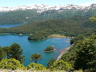
The Araucanía, Araucanía Region is one of Chile's 16 first-order administrative divisions, and comprises two provinces: Malleco in the north and Cautín in the south. Its capital and largest city is Temuco; other important cities include Angol and Villarrica.
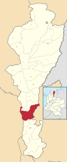
La Gloria is a municipality and town in the Department of Cesar, northern Colombia by the Magdalena River.

Remolino is a town and municipality of the Colombian Department of Magdalena. Founded between 1752 and 1776 by Fernando de Mier y Guerra. Erected municipality in 1814.

Algadefe is a municipality located in the province of León, Castile and León, Spain. According to the 2010 census (INE), the municipality has a population of 315 inhabitants.
Poza de la Vega is a municipality located in the province of Palencia, Castile and León, Spain. According to the 2004 census (INE), the municipality has a population of 267 inhabitants.

Sotobañado y Priorato is a municipality located in the province of Palencia, Castile and León, Spain. According to the 2004 census (INE), the municipality had a population of 179 inhabitants.

Villaeles de Valdavia is a municipality located in the province of Palencia, Castile and León, Spain. According to the 2004 census (INE), the municipality has a population of 74 inhabitants.

Sotresgudo is a municipality and town located in the province of Burgos, Castile and León, Spain. According to the 2004 census (INE), the municipality has a population of 645 inhabitants.

Tubilla del Lago is a municipality located in the province of Burgos, Castile and León, Spain. According to the 2004 census (INE), the municipality had a population of 170 inhabitants.
Geria is a municipality located in the province of Valladolid, Castile and León, Spain. According to the 2004 census (INE), the municipality has a population of 520 inhabitants.

Traspinedo is a municipality located in the province of Valladolid, Castile and León, Spain. According to the 2004 census (INE), the municipality has a population of 905 inhabitants.

Tudela de Duero is a municipality located in the province of Valladolid, Castile and León, Spain. According to the 2015 census (INE), the municipality has a population of 8,683 inhabitants.

Velliza is a municipality located in the province of Valladolid, Castile and León, Spain. According to the 2004 census (INE), the municipality has a population of 149 inhabitants.
Coxquihui is a municipality in Veracruz, Mexico. It is located in montane central zone of the state, about 95 km from state capital Xalapa. It has a surface of 86.37 km2. It is located at 20°11′N97°35′W.
Rafael Lucio is a municipality located in the montane central zone of the State of Veracruz, about 9 km from state capital Xalapa. It has a surface of 24.68 km2. It is located at 19°35′N96°59′W. By Decree of November 5, 1932 Rafael Lucio's municipality and the head-board is created they are named Rafael Lucio, in honor of the illustrious doctor of Xalapa.

Texcatepec is a municipality located in the north zone in the State of Veracruz, about 190 km from state capital Xalapa. It has a surface of 153.61 km2. It is located at 20°35′N98°22′W. In 1930 the municipal head-board was established in the village of Amexac; but for the decree number 4 in 1931 returned the character of municipal head-board, to the village of Texcatepec.
Zozocolco de Hidalgo is a municipality located in northwest
Banderilla is a municipality located in the central zone of the State of Veracruz, Mexico, about 9 km from the state capital, Xalapa. It has a surface area of 22.21 km². It is located at 19°35′N96°56′W. Tradition has it that the name alludes to a small flag (banderilla) that thieves would hoist on the summit of the hill of La Martinica as a signal to their accomplices that a valuable goods were being moved along the royal highway.

Hinojales is a town and municipality located in the province of Huelva, Spain. According to the 2008 census, the municipality had a population of 338 inhabitants.


