Related Research Articles

Markham is a city in the York Region of Ontario, Canada. It is approximately 30 km (19 mi) northeast of Downtown Toronto. In the 2021 Census, Markham had a population of 338,503, which ranked it the largest in York Region, fourth largest in the Greater Toronto Area (GTA), and 16th largest in Canada.

Richmond Hill is a city in south-central York Region, Ontario, Canada. Part of the Greater Toronto Area, it is the York Region's third most populous municipality and the 27th most populous municipality in Canada. Richmond Hill is situated between the cities of Markham and Vaughan, north of Thornhill, and south of Aurora.

The Rouge River is a river in Markham, Pickering, Richmond Hill and Toronto in the Greater Toronto Area of Ontario, Canada. The river flows from the Oak Ridges Moraine to Lake Ontario at the eastern border of Toronto, and is the location of Rouge Park, the only national park in Canada within a municipality. At its southern end, the Rouge River is the boundary between Toronto and southwestern Pickering in the Regional Municipality of Durham.
Stouffville is the primary urban area within the town of Whitchurch-Stouffville in York Region, Ontario, Canada. It is situated within the Greater Toronto Area and the inner ring of the Golden Horseshoe. The urban area is centred at the intersection of Main Street, Mill Street, and Market Street. Between 2006 and 2011, the population of the Community of Stouffville grew 100.5% from 12,411 to 24,886, or from 51% to 66% of the total population of the larger town of Whitchurch-Stouffville. The population of Stouffville from the 2021 census is 36,753.

Bathurst Street is a main north–south thoroughfare in Toronto, Ontario, Canada. It begins at an intersection of the Queens Quay roadway, just north of the Lake Ontario shoreline. It continues north through Toronto to the Toronto boundary at Steeles Avenue. It is a four-lane thoroughfare throughout Toronto. The roadway continues north into York Region where it is known as York Regional Road 38.

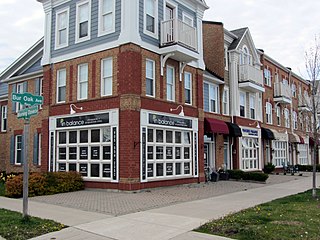
Unionville is a suburban district and former village in Markham, Ontario, Canada, 2 km (2.5 mi) west of Markham Village, and 33 km (20.5 mi) northeast of Downtown Toronto. The boundaries of Unionville are not well-defined. Several neighbourhoods claim to be part of it however, this has been disputed between the various wards.

Meadowvale is a large suburban district located in the northwestern part of Mississauga, Ontario, Canada, just west of Toronto. In the 19th and early 20th centuries, Meadowvale Village in Toronto Township was established nearby and named for the meadows along the Credit River. By the 1970s the village would diminish with the current area to the west selected to be the site of a "new town" for the newly (1974) incorporated City of Mississauga and took the Meadowvale name, while "Village" was added to the historic community. This newer section comprises the bulk of the district today, and includes Lisgar, another former hamlet of which no trace remains today. Another extension of the district at Derry Road is referred to as Meadowvale West.

Markham GO Station is a railway station on the GO Transit Stouffville line network located on Markham Main Street North in Markham, Ontario in Canada.
Cornell is a new community village being developed in northeast Markham, Ontario and bounded by Highway 407, 16th Avenue, Ninth Line, and the Donald Cousens Parkway. The 2011 population of this area was 9,880. Adding Cornell North's 2,178 it had 12,058 residents.
Box Grove(Census Tract 5350400.01) is an original community in Markham, Ontario.
MoveOntario 2020 was a 2007 plan proposed by the Government of Ontario that would fund 52 rapid-transit projects throughout the Greater Toronto and Hamilton Area in Ontario, Canada. It was succeeded by The Big Move and GO Transit's Go 2020.
The city of Markham in Ontario, Canada, offers a complex transportation infrastructure. These include airports, highways, public transit, regional roads, municipality-funded roads, and train services.

Downtown Markham is the main central business district of Markham, Ontario, Canada. Currently under development, it is located within Markham Centre near the historic Unionville district and is proposed to serve as the heart of Markham. Businesses in the district are expected to employ up to 16,000 individuals, and it may house as many as 10,000 residents. The development plans will have a high density of residential, retail, commercial and mixed-use structures. The community is being developed, built and wholly financed by The Remington Group Inc.
Woodbine Avenue is a north–south arterial road consisting of two sections in Toronto and York Region in Ontario, Canada.

Locust Hill is a historic community of Markham, Ontario centred on Hwy. 7 and the Canadian Pacific Railway and within the boundaries of the future national Rouge Park.
Old Bailey Bridge is a Bailey bridge located below 16th Avenue east of Reesor Road within Rouge Park in Markham, Ontario, Canada. The bridge crossed the Little Rouge Creek, a tributary of the Rouge River. A new bridge was built above this bridge to provide two way access for 16th Avenue east of Ressor Road. The old bridge is in situ with ends fenced off to prevent trespassing.

The Tooleybuc Bridge is a dual heritage-listed road bridge that carries Tooleybuc Road across the Murray River, located in Tooleybuc, New South Wales, Australia. It was built in 1925. The bridge is owned by the Transport for NSW, and is also called the Tooleybuc Bridge over Murray River. The bridge was added to the New South Wales State Heritage Register on 20 June 2000 and the Victorian Heritage Register on 10 July 2008.
References
- ↑ "Rouge Valley Mills and Vinegar Hill". Archived from the original on 2015-01-01.
- ↑ "City of Markham's Inventory of Heritage Properties". www2.markham.ca. Archived from the original on 2015-01-10.
- ↑ "City of Markham's Inventory of Heritage Properties". www2.markham.ca. Archived from the original on 2015-01-10.
- ↑ "City of Markham's Inventory of Heritage Properties". www2.markham.ca. Archived from the original on 2015-01-10.
- ↑ "Heritage Property Search". Archived from the original on 2020-06-21.