Hydroelectricity is electricity produced from hydropower. In 2015, hydropower generated 16.6% of the world's total electricity and 70% of all renewable electricity, and was expected to increase about 3.1% each year for the next 25 years.

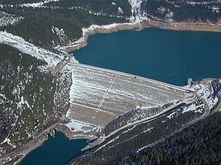
The El Chocón Dam is the fourth of the five dams on the Limay River in the northwestern Argentine Patagonia, at 381 metres (1,250 ft) above mean sea level. El Chocón is on the Limay River at about 80 km (50 mi) upstream of its confluence with the Neuquén River.

The Kpong Dam, also known as the Akuse Dam, is a hydroelectric power generating dam on the lower Volta River near Akuse in Ghana. It is owned and operated by Volta River Authority. It was constructed between 1977 and 1982. Its power station has a capacity of 148 megawatts (198,000 hp) with all four units running, though the total nameplate capacity is 160 megawatts (210,000 hp).

The Machadinho Hydroelectric Power Plant is a dam and hydroelectric power plant on the Pelotas River near Machadinho on the border of Santa Catarina and Rio Grande do Sul, Brazil. The power station has a 1,140 MW (1,530,000 hp) capacity and is supplied with water by a concrete face rock-fill embankment dam. It is owned and operated by Machadinho Energetica and produces the equivalent of 37% of the energy consumed in Santa Catarina.

The Tianshengqiao-II Dam is a dam and hydroelectric power station on the Nanpan River in the Anlong and Longlin districts in China. Construction of the dam and power plant began in 1982 and was complete in 1997.
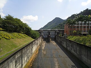
The Minghu Dam (Chinese: 明湖水壩; pinyin: Mínghú Shuǐbà, renamed the Takuan Dam, is a concrete gravity dam on the Shuili River located 7 km north of Shuili Township in Nantou County, Taiwan. The reservoir formed by the dam serves as the lower reservoir for the Minhu Pumped Storage Hydro Power Station. Sun Moon Lake serves as the upper reservoir.

The Sogamoso Dam is a concrete-face rock-fill dam on the Sogamoso River in northern Colombia. It is located 30 kilometres (19 mi) west of Bucaramanga in Santander Department and 285 kilometres (177 mi) north of Bogotá. The primary purpose of the dam is hydroelectric power generation and its power plant has an installed capacity of 820 megawatts (1,100,000 hp) which increased Colombia's generating capacity by 10 percent. Construction on the dam began in February 2009 and its first 273 MW Francis turbine-generator was commissioned on 1 December 2014. The other two generators were operational by 20 December 2014. The US$1.74 billion dam and power plant is owned by ISAGEN. INGETEC designed the dam in the 1990s and Impreglio was awarded the contract for construction.

The Kavşak Bendi Dam is a concrete-face rock-fill dam on the Seyhan River bordering Kozan and Aladağ districts in Adana Province, Turkey. Construction on the dam began in 2008 and the first generator was commissioned in 2013. The two remaining generators were commissioned by April 2014. The primary purpose of the dam is hydroelectric power generation. Water is sent about 2.5 km (1.6 mi) downstream where it meets the power station which contains three 59 MW Francis turbine-generators.
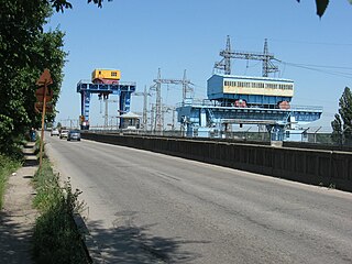
The Kremenchuk Hydroelectric Power Plant is a run-of-river power plant on the Dnieper River just upstream of Kremenchuk in Svitlovodsk, Ukraine. The primary purpose of the dam is hydroelectric power generation and navigation. It is the third dam in the Dnieper cascade and creates the largest reservoir on the river. The dam has an associated lock and a power station with an installed capacity of 624 megawatts (837,000 hp). Construction on the dam began in May 1954, the reservoir began to fill in October 1959, the last generator was commissioned in 1960 and the dam and power plant were inaugurated in 1961. It is operated by Ukrhydroenerho.

The Lower Paunglaung Dam is a rock-fill embankment dam on the Paunglaung River, about 14 kilometres (8.7 mi) east of Pyinmana in Naypyidaw Union Territory, Burma. The primary purpose of the dam is hydroelectric power generation and it had been under study since 1953. Construction began in 1996 and the first generators were commissioned in 2004 and the last in 2005. Cost of the dam and power station, funded by the Chinese government, was US$201.8 million. The dam's power house is located underground near the toe and spillway. It contains four 70 megawatts (94,000 hp) Francis turbine-generators. The Upper Paunglaung Dam, being constructed upstream, is expected to regulate the river and improved power generation.
The Shweli I Dam is a gravity dam on the Shweli River about 23 kilometres (14 mi) southwest of Namhkam in Shan State, Burma. The primary purpose of the dam is hydroelectric power generation and it supports a 600 megawatts (800,000 hp)power station. Water from the dam's reservoir is diverted through a 5.1 kilometres (3.2 mi) long headrace tunnel to the power station downstream. The drop in elevation affords a hydraulic head of 299 metres (981 ft). Construction on the dam began in 2002 and the river was diverted on 10 December 2006. On 5 September 2008, the first generator was commissioned and the last of the six was commissioned in April 2009. The dam and power station was constructed under the build–operate–transfer method and cost US$756.2 million. It is owned and operated by the Shweli River-I Power Station Co. The Shweli II and Shweli III Dams are planned downstream.

Mandraka Dam is a gravity dam on the Mandraka River near Mandraka in the Analamanga Region of Madagascar. The dam was constructed by a French firm by 1956 and creates Lake Mandraka.

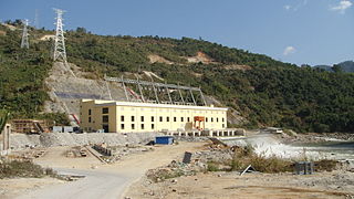
The Grand Poubara Dam is a gravity dam on the Ogooué River, about 15 kilometres (9.3 mi) south of Franceville in Gabon. The primary purpose of the dam is hydroelectric power generation and it supports a 160 megawatts (210,000 hp) power station. Construction on the project began in November 2008, the river was diverted in November 2010, and the power station was commissioned on 5 August 2013. The dam diverts the river around the Poubara Falls where four 40-megawatt (54,000 hp) Francis turbine-generators are powered. The majority of the dam and power station was funded by the Chinese government and the project was constructed by Sinohydro.

The Djibloho Dam is a gravity dam on the Wele River near Djibloho in Wele-Nzas, Equatorial Guinea. The primary purpose of the dam is hydroelectric power generation and it supports a 120 megawatts (160,000 hp) power station. Construction on the project began in 2008 and it was inaugurated in October 2012. It is the largest hydroelectric power station in the country. Most of the project's cost was funded by the host government but some funds were provided by the Chinese government. Sinohydro constructed the dam and power station.

The Afulilo Dam is a gravity dam on the Afulilo River about 3 km (1.9 mi) south of Ta'elefaga in the district of Va'a-o-Fonoti on Upolu island of Samoa. The primary purpose of the dam is hydroelectric power generation and it supports a 4 megawatts (5,400 hp) power station. It is the largest hydroelectric power station by installed capacity in Samoa. First studied in 1980, construction on the project began in 1990 and the power station was commissioned in 1993. Funding for the US$26.6 million project was provided by the World Bank, Asian Development Bank, International Development Association, European Investment Bank, and European Economic Community loans and grants.
The Condor Cliff Dam, formerly known as Néstor Kirchner Dam and previously Condor Cliff Dam, is a concrete-face rock-fill dam being built on the Santa Cruz River about 180 km (110 mi) west of Puerto Santa Cruz in Santa Cruz Province, Argentina. It was renamed after the former president Néstor Kirchner, born in Santa Cruz. A consortium led by China's Gezhouba Group was awarded the contract to build the Néstor Kirchner Dam and Jorge Cepernic Dam downstream in August 2013. The consortium will also fund the construction. Both dams are expected to cost nearly US$4.8 billion. It will be built by the firm Electroingeniería, led by Osvaldo Acosta and Gerardo Ferreyra. The primary purpose of the dam is hydroelectric power generation and its power station will have an installed capacity of 1,140 megawatts (1,530,000 hp).
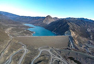
The Lost Caracoles Dam, or Caracoles Dam is a concrete-face rock-fill dam on the San Juan River about 44 kilometres (27 mi) west of San Juan in San Juan Province, Argentina. The purpose of the dam is to provide water for irrigation and the generation of hydroelectric power. The 136-metre (446 ft) tall dam supports a 126 megawatts (169,000 hp) power station and together with the Punta Negra Dam downstream, it provides for the irrigation of 15,000 hectares. Construction began in 2004 and the dam and power station were completed in 2009.
The Punta Negra Dam is a concrete-face rock-fill dam on the San Juan River about 28 kilometres (17 mi) west of San Juan in San Juan Province, Argentina. The purpose of the dam is to provide water for irrigation and the generation of hydroelectric power. The 101 metres (331 ft) tall dam supports a 62-megawatt (83,000 hp) power station and together with the Los Caracoles Dam upstream, it will provide for the irrigation of 15,000 hectares. Construction began in 2009 and the dam and was finished in August 29, 2015. It is being constructed immediately upstream of an diversion barrage.

The Mancotal Dam is an embankment dam on the Tuma River near Asturias in Jinotega Department, Nicaragua. It forms Lake Apanás, the largest reservoir in the country. The primary purpose of the dam is hydroelectric power generation and it supports the 50 MW Centro América Plant. The dam was completed and its first generator commissioned in 1964. The second generator was commissioned a year later on 18 March 1965. To generate power, water from the southwestern end of the Lake Apanás flows along a 4,000 m (13,000 ft) long channel before it enters a series of headrace pipes and a penstock. About 3.4 km (2.1 mi) to the south west the penstock meets Centro América Plant where it turns two 25 MW Francis turbines. After generating power the water is then discharged into the Viejo River. To supplement levels in the Lake Apanás, the El Dorado Dam was completed in 1985 and forms Lake Asturias just downstream of the Mancotal Dam. Water from Lake Asturias can be pumped into Lake Apanás. In 1998 heavy rains from Hurricane Mitch severely damaged the Mancotal and El Dorado Dams, over-topping their spillways and nearly destroying the dams. The Virgen Dam downstream on the Viejo River was destroyed but later rebuilt.
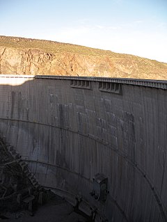
The Agua del Toro Dam is an arch dam on the Diamante River about 63 kilometres (39 mi) west of San Rafael in Mendoza Province, Argentina. The primary purpose of the dam is hydroelectric power generation and it supports a 150 megawatts (200,000 hp) power station located downstream. Construction on the dam began in 1966 and it was completed in 1973. The power station was started the same year and commissioned in 1982. The dam and power station is part of the Rio Diamante System which is owned jointly by Hidroeléctrica Diamante (HIDISA) and Hidroeléctrica de los Nihuiles (HINISA).