
Bodegraven is a town and former municipality in the western Netherlands, in the province of South Holland. The former municipality covers an area of 38.50 km2 (14.86 sq mi) of which 1.02 km2 (0.39 sq mi) is water.

Leidschendam-Voorburg is a municipality in the western Netherlands, located in the province of South Holland. It had a population of 76,433 in 2021, and covers an area of 35.62 km2 (13.75 sq mi) of which 3.07 km2 (1.19 sq mi) is water.
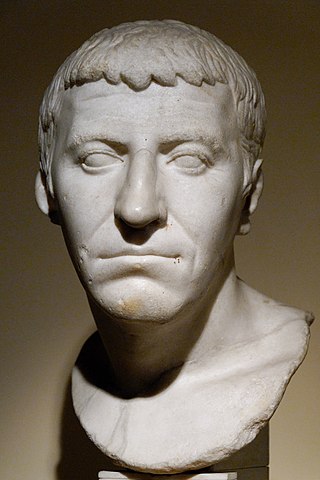
Gnaeus Domitius Corbulo was a popular Roman general, brother-in-law of the emperor Caligula and father-in-law of Domitian. The emperor Nero, highly fearful of Corbulo's reputation, ordered him to commit suicide, which the general carried out faithfully, exclaiming "Axios", meaning "I am worthy", and fell on his own sword.

Nederrijn is the Dutch part of the Rhine from the confluence at the town of Angeren of the cut-off Rhine bend of Oude Rijn (Gelderland) and the Pannerdens Kanaal. The city of Arnhem lies on the right (north) bank of the Nederrijn, just past the point where the IJssel branches off. The Nederrijn flows on to the city of Wijk bij Duurstede, from where it continues as the Lek. The once-important but now small Kromme Rijn branch carries the name "Rhine" towards the city of Utrecht.

The Vecht is a Rhine branch in the Dutch province of Utrecht. It is sometimes called Utrechtse Vecht to avoid confusion with its Overijssel counterpart. The area along the river is called the Vechtstreek.

The Oude Rijn is a branch of the Rhine delta in the Dutch provinces of Utrecht and South Holland, starting west of Utrecht, at Harmelen and runs by a mechanical pumping station into the North Sea at Katwijk. Its present-day length is 52 kilometres.
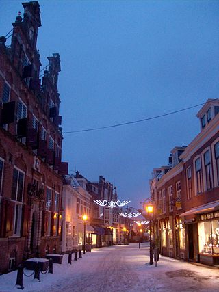
Voorburg is a town and former municipality in the west part of the province of South Holland, Netherlands. Together with Leidschendam and Stompwijk, it makes up the municipality Leidschendam-Voorburg. It has a population of about 39,000 people. It is considered to be the oldest city in The Netherlands and celebrated its 2000th year of existence in 1988. However in Holland the status of 'city' normally commenced with the bestowing of a 'city charter' by its sovereign leader(s) and none available is that old. Human occupation has certainly been established as occurring two millennia ago, where Voorburg is located now. In 2002, the cities of Leidschendam and Voorburg were merged under the new municipality named "Leidschendam-Voorburg". Situated adjacent to the city of The Hague, it is often regarded as one of its suburbs.

Leidschendam is a town and former municipality in the province of South Holland of the Netherlands. Along with Voorburg and Stompwijk, it is part of the municipality Leidschendam-Voorburg.

Forum Hadriani, in the modern town of Voorburg, was the northernmost Roman city on the European continent and the second oldest city of the Netherlands. It was located in the Roman province Germania Inferior and is mentioned on the Tabula Peutingeriana, a Roman road map.

The A4 motorway, also called Rijksweg 4, is a motorway in the Netherlands running southwards from Amsterdam to the Belgian border near Zandvliet, north of the city of Antwerp. The 119-kilometre-long (74 mi) A4 is divided into two sections; the first and longer section runs from Amsterdam to the A15 near the city of Rotterdam, while the second section starts near Heijningen, where the A29 and the A4 meet, going to the Belgian border.

The Leidse Rijn is a canal in the province of Utrecht, Netherlands.

The Gouwe is a channelized river in South Holland, the Netherlands. It runs in a north–south direction from the Oude Rijn to the Hollandse IJssel.

The Rhine–Meuse–Scheldt delta is a river delta in the Netherlands formed by the confluence of the Rhine, the Meuse and the Scheldt rivers. In some cases, the Scheldt delta is considered a separate delta to the Rhine–Meuse delta. The result is a multitude of islands, branches and branch names that may at first sight look bewildering, especially as a waterway that appears to be one continuous stream may change names as many as seven times, e.g. Rhine → Bijlands Kanaal → Pannerdens Kanaal → Nederrijn → Lek → Nieuwe Maas → Het Scheur → Nieuwe Waterweg. Since the Rhine contributes most of the water, the shorter term Rhine Delta is commonly used. However, this name is also used for the delta where the Alpine Rhine flows into Lake Constance, so it is clearer to call the larger one Rhine–Meuse delta, or even Rhine–Meuse–Scheldt delta, as the Scheldt ends in the same delta. By some calculations, the delta covers 25,347 km2 (9,787 sq mi), making it the largest in Europe.
Gracht is a Dutch word for a canal within a city. Grachten often have a round shape, and form a circle around the city cores in the Netherlands, Belgium, and northern Germany. Outside the Netherlands, the word grachten mostly refers to the city canals of Amsterdam and also Utrecht, Leiden and The Hague. The Koninginnegracht in The Hague was conceived by King Willem I for the promotion of tourism in the early 19th century. Since 2009 the Willemsvaart once more offers tours over this gracht, to Scheveningen, known as "StrandRelax" or "BeachRelax", a unique stretch of sand between The Hague and the sea.
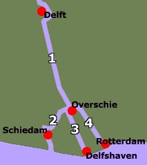
Schie the name for four waterways in the area of Overschie, South Holland, the Netherlands. There are the Delftse Schie, the Delfshavense Schie, the Rotterdamse Schie and the Schiedamse Schie. The existence of these four streams is the result of medieval rivalry among the cities of Delft, Rotterdam, and Schiedam for toll rights.

Brittenburg was a Roman ruin site west of Leiden between Katwijk aan Zee and Noordwijk aan Zee, presumably identical to the even older Celtic Lugdunum fortress. The site is first mentioned in 1401, was uncovered more completely by storm erosion in 1520, 1552 and 1562, and has subsequently been entirely eroded away. When built, it was located at the mouth of the Oude Rijn, which has since moved. The site was about a kilometre west of the European Space Research and Technology Centre, now offshore in the North Sea).

For around 450 years, from around 55 BC to around 410 AD, the southern part of the Netherlands was integrated into the Roman Empire. During this time the Romans in the Netherlands had an enormous influence on the lives and culture of the people who lived in the Netherlands at the time and (indirectly) on the generations that followed.
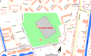
Matilo or Matilone was once a Roman fort (castellum) in modern-day Leiden. Positioned on the southern banks of the Oude Rijn, it served to protect the Roman borders in the province of Germania Inferior. On the Peutinger map, it lies between the encampments of Albaniana and Praetorium Agrippinae (Valkenburg). The seventh-century Ravenna Cosmography gives its name as Matellionem.
Albaniana was the name the ancient Romans gave a settlement on the southern banks of Rhine river, some 40 kilometers from its mouth in the North Sea, known as Alfen and modern-day Alphen aan den Rijn, Netherlands. They did build a military fort there, as part of a range strategically built encampments, to protect and guard the river, frontier (limes) of the Roman empire and main transport route of goods and troops. The historical map Tabula Peutingeriana situates the settlement in between Matilo (Leiden) and Praetorium Agrippinae (Valkenburg) downstream and Nigrum Pullum (Zwammerdam) and Fectio (Vechten) upstream. The village was mentioned in Antoninus' register of roads Itinerarium Antonini from the 3rd century. The fortress must have been surrounded by a wall of ground and wooden poles, with gates and watch towers.
