| Waitaha | |
|---|---|
| Iwi (tribe) in Māoridom | |
| Rohe (region) | South Island |
| Waka (canoe) | Uruaokapuarangi |
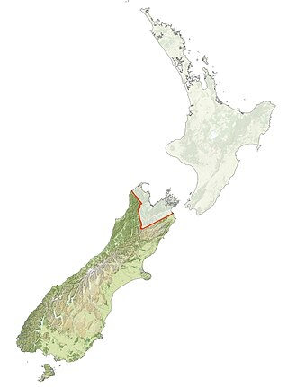
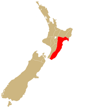
Waitaha, an early Māori iwi, inhabited the South Island of New Zealand. [1] They were largely absorbed via marriage and conquest - first by the Ngāti Māmoe and then by Ngāi Tahu - from the 16th century onward. Today those of Waitaha descent are represented by the Ngāi Tahu iwi. Like Ngāi Tahu today, Waitaha was itself a collection of various ancient iwi. Kāti Rākai was said to be one of Waitaha's hapū. [2]
Waitaha's earliest ancestors are traditionally traced as arrivals from Te Patunui-o-āio [lower-alpha 1] in Eastern Polynesia aboard the Uruaokapuarangi canoe (waka), of which Rākaihautū had been the captain. [4] He was accompanied by his wife and son, Waiariki-o-āio and Te Rakihouia, [lower-alpha 2] the renowned tohunga kōkōrangi (astronomer) Matiti, [3] Waitaa, [7] [lower-alpha 3] and other kin of the Te Kāhui Tipua, Te Kāhui Roko, and Te Kāhui Waitaha iwi. [8] When genealogies are interpreted with 25–30 years' worth of lifespan for at least 34 generations, [9] these people are calculated to have lived in or around the 9th century at the latest, [10] but this is not an entirely reliable way to trace earlier occupants of New Zealand.
A traditional story tells how Rākaihautū used Kapakitua, his adze, [lower-alpha 4] to cut a path through heavy fog on the canoe's voyage. [4] Other traditional stories such as the story of Ngā Puna Wai Karikari o Rākaihautū (roughly translated as "The Flowing Water Diggings of Rākaihautū"), credit Rākaihautū with travelling down the Southern Alps to Foveaux Strait from Boulder Bank, digging up many great lakes and waterways with Tūwhakarōria - his magical kō (digging stick), [10] and filling them with food as he went. Te Rakihouia and Waitaa also journeyed down along the east coast as far south as the Clutha River. [7] The two groups met up near the Waitaki River, where the Uruaokapuarangi is still said to lie as part of the riverbed today. [7] The party then moved back northwards to live at Banks Peninsula, where Rākaihautū renamed Tūwhakarōria to Tuhiraki, thrusting it into a hill called Pūhai where it turned into the rocky peak known to Pākehā today as Mount Bossu. [12] According to Sir Āpirana Ngata, it is "very doubtful" that Rākaihautū went south at all, saying specifically in an audio recording with John Te Herekiekie Grace: [13]
He landed in the north. Whether he went south is very doubtful. They localized him in the South Island because the people who knew the position moved south. Well, that was somewhere about the ninth century.
— Āpirana Ngata, The Journal of the Polynesian Society LIX: The Io Cult - Early Migration - Puzzle of the Canoes (1950) [13]
A daughter of Rākaihautū, Te Uhi-tataraiakoa, stayed behind in Te Patunui-o-āio, and became the great grandmother of Toi. [9] Eight generations after Toi there lived Waitaha-nui and after him Waitaha-araki, [14] after whom there came Hāwea-i-te-raki, [lower-alpha 5] and finally seven generations later lived Hotumāmoe from Hastings, the founding ancestor of Ngāti Māmoe. In addition, Te Kāhea was a fifth generation descendant of Toi, and Rāhiri was also a 16th generation descendant. [9] Tūhaitara from Hastings, a famed Ngāi Tahu ancestress, was said to have some Ngāti Māmoe ancestry. [9] Her husband Marukore was a local with Te Kāhea ancestry. [15] Waiwhero and Hekeia were Waitaha chiefs, [2] with Te Anau being the latter's granddaughter [16] and Aparim-a being his mother. Otaraia was the name of another chief. [2]
Waitaha's pā included O whitianga te ra ("place of the shining sun"), close to the southern end of Lake Te Anau [16] a site at the Taerutu Lagoon near Woodend,[ citation needed ] a site at the mouth of Mata-au, a site in the Oamaru area, and a site around Lake Wakatipu. [2]
At the time Ngāti Māmoe migrated to the South Island from Te Whanganui-a-Tara about the 16th century, all the South Island's ancient iwi including the original Waitaha, Te Kāhui Tipua, Te Kāhui Roko, Te Rapuwai, Ngāti Hawea, and Ngāti Wairangi were all collectively grouped together as Waitaha. [5] [6] [8] This happened again to Kāti Māmoe when Ngāi Tahu conquered the South Island in the 17th and 18th centuries. [11]
In 1995, a book by controversial author Barry Brailsford, Song of Waitaha: The Histories of a Nation, claimed that the ancestors of a "Nation of Waitaha" were the first inhabitants of New Zealand, three groups of people of different races, two of light complexion and one of dark complexion, who had arrived in New Zealand from an unspecified location in the Pacific Ocean, 67 generations before the book appeared.[ citation needed ]
Although a series of further books, web sites and events have addressed these claims, they have been widely disputed and dismissed by scholars. Historian Michael King noted: "There was not a skerrick of evidence – linguistic, artifactual, genetic; no datable carbon or pollen remains, nothing – that the story had any basis in fact. Which would make Waitaha the first people on earth to live in a country for several millennia and leave no trace of their occupation." [17]
Several organisations have Waitaha as part of their title, often as a synonym for Canterbury or in a generic "ancient links to the land" sense. Some are:
Iwi are the largest social units in New Zealand Māori society. In Māori, iwi roughly means 'people' or 'nation', and is often translated as "tribe," or "a confederation of tribes." The word is both singular and plural in the Māori language, and is typically pluralised as such in English.

Lake Wānaka is New Zealand's fourth-largest lake and the seat of the town of Wānaka in the Otago region. The lake is 278 meters above sea level, covers 192 km2 (74 sq mi), and is more than 300 m (980 ft) deep.
Ngāi Tahu, or Kāi Tahu, is the principal Māori iwi (tribe) of the South Island. Its takiwā is the largest in New Zealand, and extends from the White Bluffs / Te Parinui o Whiti, Mount Mahanga and Kahurangi Point in the north to Stewart Island / Rakiura in the south. The takiwā comprises 18 rūnanga corresponding to traditional settlements. According to the 2018 census an estimated 74,082 people affiliated with the Kāi Tahu iwi.

Ngāti Porou is a Māori iwi traditionally located in the East Cape and Gisborne regions of the North Island of New Zealand. Ngāti Porou is affiliated with the 28th Maori Battalion, it also has the second-largest affiliation of any iwi, behind Ngāpuhi with an estimated 92,349 people according to the 2018 census. The traditional rohe or tribal area of Ngāti Porou extends from Pōtikirua and Lottin Point in the north to Te Toka-a-Taiau in the south. The Ngāti Porou iwi also comprises 58 hapū (sub-tribes) and 48 mārae.
Ngāti Kahungunu is a Māori iwi located along the eastern coast of the North Island of New Zealand. The iwi is traditionally centred in the Hawke's Bay and Wairārapa regions. The Kahungungu iwi also comprises 86 hapū (sub-tribes) and 90 marae.

Otakou is a settlement within the boundaries of the city of Dunedin, New Zealand. It is located 25 kilometres from the city centre at the eastern end of Otago Peninsula, close to the entrance of Otago Harbour. Though a small fishing village, Otakou is important in the history of Otago for several reasons. The settlement is the modern centre and traditional home of the Ōtākou rūnanga (assembly) of Ngāi Tahu. In 1946 Otakou Fisheries was founded in the township; this was later to become a major part of the Otago fishing industry.

Lake Hāwea is New Zealand's ninth largest lake.
Patupaiarehe are supernatural beings in Māori mythology that are described as pale to fair skinned with blonde hair or red hair, usually having the same stature as ordinary people, and never tattooed. They can draw mist to themselves, but tend to be nocturnal or active on misty or foggy days as direct sunlight can be fatal to them. They prefer raw food and have an aversion to steam and fire.
Kāti Māmoe is a historic Māori iwi. Originally from the Hastings area, they moved in the 16th century to the South Island which at the time was already occupied by the Waitaha.
Claims and settlements under the Treaty of Waitangi have been a significant feature of New Zealand politics since the Treaty of Waitangi Act 1975 and the Waitangi Tribunal that was established by that act to hear claims. Successive governments have increasingly provided formal legal and political opportunity for Māori to seek redress for what are seen as breaches by the Crown of guarantees set out in the Treaty of Waitangi. While it has resulted in putting to rest a number of significant longstanding grievances, the process has been subject to criticisms including those who believe that the redress is insufficient to compensate for Māori losses. The settlements are typically seen as part of a broader Māori Renaissance.

Māori mythology and Māori traditions are two major categories into which the remote oral history of New Zealand's Māori may be divided. Māori myths concern tales of supernatural events relating to the origins of what was the observable world for the pre-European Māori, often involving gods and demigods. Māori tradition concerns more folkloric legends often involving historical or semi-historical forebears. Both categories merge in whakapapa to explain the overall origin of the Māori and their connections to the world which they lived in.
The Otago region of New Zealand is one of the more isolated places of the inhabited earth. Its high latitude, elevation and distance from larger foreign and domestic population centres have defined Otago at each stage of its history.
Ngāi Tāmanuhiri is a Māori iwi of New Zealand and were formerly known by the name of Ngai Tahu, and Ngai Tahu-po respectively. They are descendants of Tahu-nui who is also the eponymous ancestor of the Kai Tahu iwi of Te Waipounamu.
Uruaokapuarangi was one of the great ocean-going, voyaging canoes that was used in the migrations that settled the South Island according to Māori tradition.
Te Pūoho-o-te-rangi (died 1836 or 1837), also known as Te Pūoho-ki-te-rangi, was a notable New Zealand tribal leader. A Māori, he identified with the Ngāti Tama and Ngāti Toa iwi. Te Pūoho was born in Poutama, Taranaki, New Zealand, possibly in the late eighteenth century. Late in his life, he moved to the South Island and settled at Parapara.
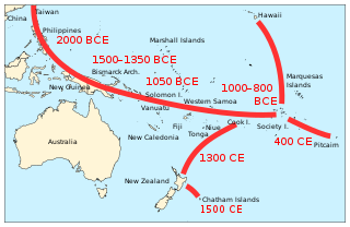
Since the early 1900s the fact that Polynesians were the first ethnic group to settle in New Zealand has been accepted by archaeologists and anthropologists. Before that time and until the 1920s, however, a small group of prominent anthropologists proposed that the Moriori people of the Chatham Islands represented a pre-Māori group of people from Melanesia, who once lived across all of New Zealand and were replaced by the Māori. While this claim was soon disproven by academics, it was widely and controversially incorporated into school textbooks during the 20th century, most notably in the School Journal. This theory subsequently spawned modern claims of a pre-Māori settlement of New Zealand by various ethnic groups, many conspiratorial in nature. Today, such theories are considered to be pseudohistorical and negationist by scholars and historians, and racist by many observers, with the Moriori myth having been used to justify settler colonalism.
Maungaharuru Tangitū is a collective of Māori hapū (subtribes) of the Ngāti Kahungunu iwi in Hawke's Bay, New Zealand, who joined forces for Treaty of Waitangi settlement negotiations. The hapū are Marangatūhetaua, Ngāi Tauira, Ngāi Te Ruruku ki Tangoio, Ngāi Tahu, Ngāti Kurumōkihi and Ngāti Whakaari. The group's rohe ranges from Bay View in the south to the Waitaha Stream in the north, and from the Maungaharuru Range in the west to the sea in Hawke Bay, that part of the sea being known as Tangitū.
Waipounamu Māori are a group of Māori iwi at or around the South Island of New Zealand. It includes the iwi (tribe) of Ngāi Tahu and the historical iwi of Kāti Māmoe and Waitaha, who occupy the island except for its most northern districts. It also includes Te Tau Ihu Māori iwi, such as Ngāti Toa, Te Atiawa o Te Waka-a-Māui, Ngāti Apa ki te Rā Tō, Rangitāne, Ngāti Kuia, Ngāti Rārua, Ngāti Kōata and Ngāti Tama.
Rākaihautū was the captain of the Uruaokapuarangi canoe and a Polynesian ancestor of various iwi, most famously of Waitaha and other southern groups, though he is also known in the traditions of Taitokerau, and in those of Rarotonga.
Charles Eldon Fayne Robinson is a New Zealand Māori artist specialising in carving. Robinson has contributed to the carving of buildings on many marae in New Zealand as well as exhibiting his art in galleries and museums.
Waitaha/Te Kapuwai [:] The third tribe to settle in the South Island between 1477-1577. Pa at the mouth of Molyneux River, Lake Te Anau, Lake Wakatipu and Oamaru.