Wakarusa, Indiana

Last updated

Wakarusa, Indiana
Wakarusa-indiana-downtown.jpg
Downtown Wakarusa
Elkhart County Indiana Incorporated and Unincorporated areas Wakarusa Highlighted 1879478.svg
Location of Wakarusa in Elkhart County, Indiana.
Coordinates: 41°31′55″N86°00′00″W / 41.53194°N 86.00000°W / 41.53194; -86.00000
Country United States
State Indiana
County Elkhart
Township Harrison, Olive
Area
[1]
  Total2.28 sq mi (5.91 km2)
  Land2.20 sq mi (5.71 km2)
  Water0.08 sq mi (0.20 km2)
Elevation
[2]
850 ft (260 m)
Population
 (2020)
  Total1,998
  Density906.53/sq mi (350.00/km2)
Time zone UTC-5 (Eastern (EST))
  Summer (DST) UTC-4 (EDT)
ZIP code
46573
Area code 574
FIPS code 18-79478 [3]
GNIS feature ID2397717 [2]

Wakarusa is a town in Harrison and Olive townships in Elkhart County, Indiana, United States. The population was 1,758 at the 2010 census. [4]

Contents

Wakarusa is a small farming and manufacturing community located on Indiana 19 just north of Indiana 119. The town is 12 miles (19 km) south of Elkhart, 25 miles (40 km) southeast of South Bend, 120 miles (190 km) east of Chicago, and 140 miles (230 km) north of Indianapolis.

Geography

According to the 2010 census, Wakarusa has a total area of 2.277 square miles (5.90 km2), of which 2.2 square miles (5.70 km2) (or 96.62%) is land and 0.077 square miles (0.20 km2) (or 3.38%) is water. [5]

History

In 1836, rural Olive Township was formed in western Elkhart County, and in 1849, as the population grew, a post office named Mt. Olive opened. After more population growth, a new village named Salem was established to prevent people from having to travel to either Goshen or Elkhart to conduct business. Since there is already a town named Salem in Indiana, the name was changed to Wakarusa in 1859. [6] The Mt. Olive Post Office was renamed for Wakarusa a year later. [7]

Railroad - In 1891 work began on the Wabash Railroad line through town, with the official opening of the line in the spring of 1893. The line, which connected Chicago with Montpelier, Ohio, became part of the Norfolk & Western Railway in 1964 and lasted until the 1980s. Today, the original Wabash depot along with two Norfolk & Western rail cars are featured along with many other displays at the Wakarusa Historical Museum.

The etymology of the name "Wakarusa" is not known. According to tradition, the name Wakarusa is from a Native American language, meaning "knee-deep in mud". [8] A more recent source claims a settler named it after a location in Kansas. [9]

Demographics

Historical population
CensusPop.Note
1870 245
1880 37753.9%
1900 917
1910 859−6.3%
1920 816−5.0%
1930 97319.2%
1940 1,0336.2%
1950 1,14310.6%
1960 1,1450.2%
1970 1,1601.3%
1980 1,28110.4%
1990 1,66730.1%
2000 1,618−2.9%
2010 1,7588.7%
2020 1,99813.7%
U.S. Decennial Census [10]

2010 census

As of the census [11] of 2010, there were 1,758 people, 665 households, and 448 families residing in the town. The population density was 799.1 inhabitants per square mile (308.5/km2). There were 717 housing units at an average density of 325.9 per square mile (125.8/km2). The racial makeup of the town was 96.0% White, 1.0% African American, 0.1% Native American, 1.0% Asian, 0.9% from other races, and 1.1% from two or more races. Hispanic or Latino of any race were 2.4% of the population.

There were 665 households, of which 33.1% had children under the age of 18 living with them, 54.0% were married couples living together, 10.8% had a female householder with no husband present, 2.6% had a male householder with no wife present, and 32.6% were non-families. 29.9% of all households were made up of individuals, and 17% had someone living alone who was 65 years of age or older. The average household size was 2.48 and the average family size was 3.09.

The median age in the town was 42 years. 24.9% of residents were under the age of 18; 7.2% were between the ages of 18 and 24; 22.1% were from 25 to 44; 23.7% were from 45 to 64, and 22.2% were 65 years of age or older. The gender makeup of the town was 45.8% male and 54.2% female.

2000 census

As of the census [3] of 2000, there were 1,618 people, 595 households, and 427 families residing in the town. The population density was 716.0 inhabitants per square mile (276.4/km2). There were 618 housing units at an average density of 273.5 per square mile (105.6/km2). The racial makeup of the town was 97.34% White, 0.49% African American, 0.19% Asian, 0.06% Pacific Islander, 0.62% from other races, and 1.30% from two or more races. Hispanic or Latino of any race were 1.48% of the population.

Wakarusa town hall Wakarusa-indiana-town-hall.jpg
Wakarusa town hall

There were 595 households, out of which 35.3% had children under the age of 18 living with them, 58.7% were married couples living together, 10.9% had a female householder with no husband present, and 28.2% were non-families. 25.9% of all households were made up of individuals, and 13.4% had someone living alone who was 65 years of age or older. The average household size was 2.51 and the average family size was 3.04.

In the town, the population was spread out, with 26.0% under the age of 18, 7.7% from 18 to 24, 27.5% from 25 to 44, 19.0% from 45 to 64, and 19.8% who were 65 years of age or older. The median age was 37 years. For every 100 females, there were 84.7 males. For every 100 females age 18 and over, there were 79.2 males.

The median income for a household in the town was $41,515, and the median income for a family was $50,833. Males had a median income of $36,014 versus $25,300 for females. The per capita income for the town was $19,615. About 3.2% of families and 4.0% of the population were below the poverty line, including 3.8% of those under age 18 and 5.8% of those age 65 or over.

Education

Neighboring Nappanee and Wakarusa combined their school systems in the 1970s to create the Wa-Nee Community Schools.

The town has a free lending library, the Wakarusa-Olive & Harrison Township Public Library. [12]

Religion

Wakarusa has Wakarusa Missionary Church, which is the Missionary Church denomination based out of Fort Wayne, Indiana. Other churches include a Bible Baptist Church, a Methodist church, Holdemen Mennonite Church, and Olive Mennonite Church just outside Wakarusa.

Notable people

Economy

Wakarusa from the air, looking east Wakarusa-indiana-from-above.jpg
Wakarusa from the air, looking east

Originally solely a farming community, a lumber mill opened in 1866. By the 1880s, several factories and businesses existed, despite the fact that the railroad would not roll into town until 1893. [7] At one point, three different lumber mills operated in the town, though none exist today.

Today, Wakarusa continues to have a thriving farming economy and has two grain mills within the town's limits. Wakarusa's location in Elkhart County places it within a strong industrial area, and because of this, multiple manufacturers are located in the area. Recreational vehicle manufacturing, modular home manufacturing and custom truck production are the base of the industrial economy. Forest River employs nearly 600 in the RV industry.

It was announced in February 2012 that Utilimaster, a manufacturer of walk-in vans and commercial truck bodies, was moving all of its manufacturing and headquarters to nearby Bristol, about 20 minutes to the northeast in Elkhart County. Since then, RV company Forest River has purchased nearly all of the buildings and currently employs around 600 in Wakarusa.

On July 17, 2008, Monaco Coach Corporation announced the closing of its Wakarusa production plant and laid off its approximately 1400 workers. [13] Since then, the massive complex has been bought by Thor Industries, and they are using it for multiple operations for some of their RV brands. Currently, they employ around 700.

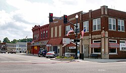
Today, the historic town center has several antique shops, hair salons, a furniture store, a hardware store, a general contractor, a florist, an I.T. business, a mechanic, insurance companies, restaurants, and a dime store candy shop that sells locally made maple syrup and jumbo jelly beans to a small but growing number of regional tourists.

Festivals

Once a year, the town hosts the Maple Syrup Festival and holds a parade as well as other activities associated with small-town celebrations. The festival was started in 1969 by the then Chamber of Progress. Originally held in March, the festival now occurs during the end of April.

Related Research Articles

<span class="mw-page-title-main">Morton County, Kansas</span> County in Kansas, United States

Morton County is a county in the southwestern corner of the U.S. state of Kansas. Its county seat and largest city is Elkhart. As of the 2020 census, the county population was 2,701. The county was named after Oliver Morton, the 14th governor of the state of Indiana.

<span class="mw-page-title-main">Elkhart County, Indiana</span> County in Indiana, United States

Elkhart County is a county located in the U.S. state of Indiana. As of 2020, the county's population was 207,047. The county seat is Goshen. Elkhart County is part of the Elkhart-Goshen Metropolitan Statistical Area, which in turn is part of the South Bend-Elkhart-Mishawaka Combined Statistical Area. It is also considered part of the broader region of Northern Indiana known as Michiana, and is 20 miles (32 km) east of South Bend, Indiana, 110 miles (180 km) east of Chicago, Illinois, and 150 miles (240 km) north of Indianapolis, Indiana. The area is referred to by locals as the recreation vehicle (RV) capital of the world and is known for its sizable Amish and Old Order Mennonite population.

<span class="mw-page-title-main">Center Point, Indiana</span> Town in Indiana, United States

Center Point is a town in Sugar Ridge Township, Clay County, Indiana, United States. The population was 242 at the 2010 census. It is part of the Terre Haute Metropolitan Statistical Area.

<span class="mw-page-title-main">St. Leon, Indiana</span> Town in Indiana, United States

St. Leon or Saint Leon is a town in Kelso Township, Dearborn County, Indiana, United States. The population was 678 at the 2010 census.

<span class="mw-page-title-main">Bristol, Indiana</span> Town in Indiana, United States

Bristol is a town in Washington Township, Elkhart County, Indiana, United States. The population was 1,602 at the 2010 census.

<span class="mw-page-title-main">Dunlap, Indiana</span> Census-designated place in Indiana, United States

Dunlap is a census-designated place (CDP) in Elkhart County, Indiana, United States. The population was 6,235 at the 2010 census. Once a small farming community, by the 1980s it had become a suburb of Elkhart and Goshen, Indiana. Most of the town was destroyed by two violent F4 tornadoes during the Palm Sunday Tornado Outbreak on April 11, 1965.

<span class="mw-page-title-main">Nappanee, Indiana</span> City in Indiana, United States

Nappanee is a city in Elkhart and Kosciusko counties in the U.S. state of Indiana. The population was 6,648 as of the 2010 U.S. Census and had grown to 6,913 by the 2020 U.S. Census. The name Nappanee is thought to mean "flour" in the Algonquian language.

<span class="mw-page-title-main">Simonton Lake, Indiana</span> Census-designated place in Indiana, United States

Simonton Lake is a census-designated place (CDP) in Elkhart County, Indiana, United States. The population was 4,678 at the 2010 census.

<span class="mw-page-title-main">Blountsville, Indiana</span> Town in Indiana, United States

Blountsville is a town in Stoney Creek Township, Henry County, Indiana, United States. The population was 98 at the 2020 census.

<span class="mw-page-title-main">Mount Etna, Indiana</span> Town in Indiana, United States

Mount Etna is a town in Huntington County, Indiana, United States. The population was 94 at the 2010 census. It lies at the intersection of four townships: Jefferson, Lancaster, Polk and Wayne.

<span class="mw-page-title-main">Pottawattamie Park, Indiana</span> Town in Indiana, United States

Pottawattamie Park is a town in Michigan Township, LaPorte County, Indiana, United States. The population was 235 at the 2010 census. It is included in the Michigan City, Indiana-La Porte, Indiana Metropolitan Statistical Area.

<span class="mw-page-title-main">Bremen, Indiana</span> Town in Indiana, United States

Bremen is a town in German Township, Marshall County, Indiana, United States. The population was 4,696 at the 2020 census.

<span class="mw-page-title-main">Amboy, Indiana</span> Town in Indiana, United States

Amboy is a town in Jackson Township, Miami County, in the U.S. state of Indiana. The population was 317 at the 2020 census, down from 384 in 2010.

<span class="mw-page-title-main">Cloverdale, Indiana</span> Town in Indiana, United States

Cloverdale is a town in Cloverdale and Warren townships, Putnam County, in the U.S. state of Indiana. The population was 2,172 at the 2010 census.

<span class="mw-page-title-main">New Carlisle, Indiana</span> Town in Indiana, United States

New Carlisle is a town in Olive Township, St. Joseph County, in the U.S. state of Indiana. The population was 1,891, as of the 2020 Census. It is part of the South Bend–Mishawaka, IN-MI, Metropolitan Statistical Area.

<span class="mw-page-title-main">Osceola, Indiana</span> Town in Indiana, United States

Osceola is a town in Penn Township, St. Joseph County, in the U.S. state of Indiana. The population was 2,463 at the 2010 Census. It is part of the South Bend–Mishawaka, IN-MI, Metropolitan Statistical Area.

<span class="mw-page-title-main">Poneto, Indiana</span> Town in Indiana, United States

Poneto is a town in Chester, Harrison and Liberty townships, Wells County, in the U.S. state of Indiana. The population was 166 at the 2010 census.

<span class="mw-page-title-main">Elkhart, Iowa</span> City in Iowa, United States

Elkhart is a city in Polk County, Iowa, United States. The population was 882 at the time of the 2020 census. It is part of the Des Moines–West Des Moines Metropolitan Statistical Area.

<span class="mw-page-title-main">Wynnedale, Indiana</span> Town in Indiana, United States

Wynnedale is a town in Washington Township, Marion County, Indiana, United States. The population was 215 at the 2020 census. It has existed as an "included town" since 1970, when it was incorporated into Indianapolis as part of Unigov. It is part of Indianapolis, but retains a functioning town government under IC 36-3-1-11.

<span class="mw-page-title-main">Millersburg, Indiana</span> Town in Indiana, United States

Millersburg is a town in Clinton and Benton townships, Elkhart County, Indiana, United States. The population was 903 at the 2010 census.

References

  1. "2020 U.S. Gazetteer Files". United States Census Bureau. Retrieved March 16, 2022.
  2. 1 2 U.S. Geological Survey Geographic Names Information System: Wakarusa, Indiana
  3. 1 2 "U.S. Census website". United States Census Bureau . Retrieved January 31, 2008.
  4. "Profile of General Population and Housing Characteristics: 2010 Demographic Profile Data (DP-1): Wakarusa town, Indiana". United States Census Bureau . Retrieved July 10, 2012.
  5. "G001 - Geographic Identifiers - 2010 Census Summary File 1". United States Census Bureau. Archived from the original on February 13, 2020. Retrieved July 25, 2015.
  6. History of Elkhart County, Indiana. Chas. C. Chapman Co. 1881. p. 1103.
  7. 1 2 Wakarusa's History
  8. Wenger, Amy Lant (2003). Around Nappanee: Hometowns of the Heritage Trail. Arcadia Publishing. p. 79. ISBN   978-0-7385-3154-0.
  9. Baker, Ronald L. (October 1995). From Needmore to Prosperity: Hoosier Place Names in Folklore and History. Indiana University Press. p. 336. ISBN   978-0-253-32866-3. ...suggested changing the name to Wakarusa for a stream or a place in Kansas, where he had once lived.
  10. "Census of Population and Housing". Census.gov. Retrieved June 4, 2015.
  11. "U.S. Census website". United States Census Bureau . Retrieved December 11, 2012.
  12. "Indiana public library directory" (PDF). Indiana State Library. Archived from the original (PDF) on February 18, 2017. Retrieved March 7, 2018.
  13. "Monaco employees shocked, Local News". goshennews.com. July 18, 2008. Archived from the original on July 11, 2011. Retrieved August 3, 2023.