Wakeman, Ohio

Last updated

Wakeman, Ohio
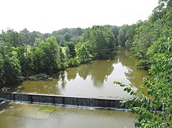
Wakeman river dam.jpg
Dam on the Vermilion River
OHMap-doton-Wakeman.png
Location of Wakeman, Ohio
Map of Huron County Ohio Highlighting Wakeman Village.png
Location of Wakeman in Huron County
Coordinates: 41°15′05″N82°24′10″W / 41.25139°N 82.40278°W / 41.25139; -82.40278
Country United States
State Ohio
County Huron
Area
[1]
  Total0.85 sq mi (2.19 km2)
  Land0.82 sq mi (2.14 km2)
  Water0.02 sq mi (0.06 km2)
Elevation
[2]
863 ft (263 m)
Population
 (2020)
  Total990
  Density1,200.00/sq mi (463.55/km2)
Time zone UTC-5 (Eastern (EST))
  Summer (DST) UTC-4 (EDT)
ZIP code
44889
Area code 440
FIPS code 39-80458
GNIS feature ID2400081 [2]

Wakeman is a village in Huron County, Ohio, United States, along the Vermilion River. Its namesake was Jesup Wakeman, [3] an early settler of Fairfield County, Connecticut, who was involved in western land speculation between 1800 and 1840. The population was 990 at the 2020 census.

Contents

Geography

According to the United States Census Bureau, the village has a total area of 0.85 square miles (2.20 km2), of which 0.83 square miles (2.15 km2) is land and 0.02 square miles (0.05 km2) is water. [4] The surface of Wakeman and the surrounding township is generally rolling. The soil is sandy and loamy with more clay content in some portions of the land. [5]

Demographics

Historical population
CensusPop.Note
1930 452
1940 52215.5%
1950 62018.8%
1960 72817.4%
1970 82212.9%
1980 90610.2%
1990 9484.6%
2000 9510.3%
2010 1,04710.1%
2020 990−5.4%
U.S. Decennial Census [6]

2010 census

As of the census [7] of 2010, there were 1,047 people, 402 households, and 288 families living in the village. The population density was 1,261.4 inhabitants per square mile (487.0/km2). There were 441 housing units at an average density of 531.3 per square mile (205.1/km2). The racial makeup of the village was 99.0% White, 0.2% African American, 0.1% Native American, 0.1% from other races, and 0.6% from two or more races. Hispanic or Latino of any race were 1.2% of the population.

There were 402 households, of which 38.3% had children under the age of 18 living with them, 54.0% were married couples living together, 12.4% had a female householder with no husband present, 5.2% had a male householder with no wife present, and 28.4% were non-families. 21.9% of all households were made up of individuals, and 9.2% had someone living alone who was 65 years of age or older. The average household size was 2.60 and the average family size was 3.03.

The median age in the village was 36.7 years. 28.7% of residents were under the age of 18; 5.6% were between the ages of 18 and 24; 28% were from 25 to 44; 26.5% were from 45 to 64; and 11.3% were 65 years of age or older. The gender makeup of the village was 48.0% male and 52.0% female.

2000 census

As of the census [8] of 2000, there were 951 people, 359 households, and 268 families living in the village. The population density was 1,195.9 inhabitants per square mile (461.7/km2). There were 374 housing units at an average density of 470.3 per square mile (181.6/km2). The racial makeup of the village was 99.05% White, 0.32% from other races, and 0.63% from two or more races. Hispanic or Latino of any race were 0.95% of the population.

There were 359 households, out of which 39.6% had children under the age of 18 living with them, 60.7% were married couples living together, 10.6% had a female householder with no husband present, and 25.1% were non-families. 20.3% of all households were made up of individuals, and 9.7% had someone living alone who was 65 years of age or older. The average household size was 2.65 and the average family size was 3.08.

In the village, the population was spread out, with 28.1% under the age of 18, 7.9% from 18 to 24, 30.0% from 25 to 44, 23.3% from 45 to 64, and 10.7% who were 65 years of age or older. The median age was 36 years. For every 100 females there were 97.7 males. For every 100 females age 18 and over, there were 90.5 males.

The median income for a household in the village was $50,125, and the median income for a family was $55,500. Males had a median income of $36,458 versus $24,028 for females. The per capita income for the village was $18,559. About 1.1% of families and 3.2% of the population were below the poverty line, including 0.8% of those under age 18 and 5.8% of those age 65 or over.
Education

Public education for Wakeman is administered by Western Reserve Local School District. [9]

Wakeman is served by a branch of the Huron County Community Library. [10]

Notable people

Related Research Articles

<span class="mw-page-title-main">Huron County, Ohio</span> County in Ohio, United States

Huron County is a county located in the U.S. state of Ohio. As of the 2020 census, the population was 58,565. Its county seat is Norwalk. The county was created in 1809 and later organized in 1815.

<span class="mw-page-title-main">Huron, Kansas</span> City in Kansas, United States

Huron is a city in Atchison County, Kansas, United States. As of the 2020 census, the population of the city was 74.

<span class="mw-page-title-main">Elkton, Michigan</span> Village in Michigan, United States

Elkton is a village in Huron County in the U.S. state of Michigan. The population was 796 at the 2020 census. The village is within Oliver Township, along the Pinnebog River. It was incorporated in 1897.

<span class="mw-page-title-main">Kinde, Michigan</span> Village in Michigan, United States

Kinde is a village in Huron County in the U.S. state of Michigan. The population was 448 at the 2010 census.

<span class="mw-page-title-main">Oliver Township, Huron County, Michigan</span> Civil township in Michigan, United States

Oliver Township is a civil township of Huron County in the U.S. state of Michigan. The population was 1,419 at the 2020 census.

<span class="mw-page-title-main">Owendale, Michigan</span> Village in Michigan, United States

Owendale is a village in Huron County of the U.S. state of Michigan. The population was 241 at the 2010 census. The village is within Brookfield Township.

<span class="mw-page-title-main">Pigeon, Michigan</span> Village in Michigan, United States

Pigeon is a village in Huron County in the U.S. state of Michigan. The population was 1,208 at the 2010 census. The village is within Winsor Township.

<span class="mw-page-title-main">Port Austin, Michigan</span> Village in Michigan, United States

Port Austin is a village in Huron County in the U.S. state of Michigan. The population was 664 at the 2010 census. The village is within Port Austin Township.

<span class="mw-page-title-main">Rubicon Township, Michigan</span> Civil township in Michigan, United States

Rubicon Township is a civil township of Huron County in the U.S. state of Michigan. The population was 705 at the 2020 census.

<span class="mw-page-title-main">Hillman, Michigan</span> Village in Michigan, United States

Hillman is a village in Alpena and Montmorency counties in the U.S. state of Michigan. The population was 605 as of the 2020 census. Nearly all of the village is located within Hillman Township, with only a small portion extending into Green Township.

Hillman Township is a civil township of Montmorency County in the U.S. state of Michigan. The population was 2,009 at the 2020 census, 604 of whom lived in the village of Hillman within the township.

<span class="mw-page-title-main">Carsonville, Michigan</span> Village in Michigan, United States

Carsonville is a village in Sanilac County of the U.S. state of Michigan. The population was 527 at the 2010 census. The village is situated at 43°25′37″N82°40′17″W on the boundary between Bridgehampton Township and Washington Township, with about half the village in each.

<span class="mw-page-title-main">Forestville, Michigan</span> Village in Michigan, United States

Forestville is a village in Sanilac County in the U.S. state of Michigan. The population was 104 at the 2020 census, making it the least-populous village in Michigan. It does not have a true harbor onto Lake Huron, but the village does have a boat launch site. Forestville receives city water from nearby Harbor Beach. The village is within Delaware Township.

<span class="mw-page-title-main">Emmett, Michigan</span> Village in Michigan, United States

Emmett is a village in St. Clair County of the U.S. state of Michigan. The population was 269 at the 2010 census. The village is located within Emmett Township.

<span class="mw-page-title-main">Castalia, Ohio</span> Village in Ohio, United States

Castalia is a village in Erie County, Ohio, United States. The population was 774 at the 2020 census. It is part of the Sandusky, Ohio Metropolitan Statistical Area.

<span class="mw-page-title-main">Greenwich, Ohio</span> Village in Ohio, United States

Greenwich is a village in Huron County, Ohio, United States. The population was 1,409 at the 2020 census. It is served by a branch of the Willard Memorial Library.

<span class="mw-page-title-main">Monroeville, Ohio</span> Village in Ohio, United States

Monroeville is a village in Huron County, Ohio, United States. The population was 1,300 at the 2020 census.

<span class="mw-page-title-main">New London, Ohio</span> Village in Ohio, United States

New London is a village in Huron County, Ohio, United States. The population was 2,416 at the 2020 census.

<span class="mw-page-title-main">North Fairfield, Ohio</span> Village in Ohio, United States

North Fairfield is a village in Huron County, Ohio, United States. The population was 465 at the 2020 census.

<span class="mw-page-title-main">Plymouth, Ohio</span> Village in Ohio, United States

Plymouth is a village in Huron and Richland counties in the U.S. state of Ohio. The population was 1,707 at the 2020 census.

References

  1. "ArcGIS REST Services Directory". United States Census Bureau. Retrieved September 20, 2022.
  2. 1 2 U.S. Geological Survey Geographic Names Information System: Wakeman, Ohio
  3. Mangus, Michael; Herman, Jennifer L. (2008). Ohio Encyclopedia. North American Book Dist LLC. p. 565. ISBN   978-1-878592-68-2.
  4. "US Gazetteer files 2010". United States Census Bureau . Retrieved January 6, 2013.
  5. "History". florencetwp.com. Retrieved May 10, 2021.
  6. "Census of Population and Housing". Census.gov. Retrieved June 4, 2015.
  7. "U.S. Census website". United States Census Bureau . Retrieved January 6, 2013.
  8. "U.S. Census website". United States Census Bureau . Retrieved January 31, 2008.
  9. "Schools in Wakeman". Trulia. Retrieved February 26, 2018.
  10. "Homepage". Huron County Community Library. Retrieved February 26, 2018.