The Appalachian Trail, is a hiking trail in the Eastern United States, extending almost 2,200 miles (3,540 km) between Springer Mountain in Georgia and Mount Katahdin in Maine, and passing through 14 states. The Appalachian Trail Conservancy claims the Appalachian Trail to be the longest hiking-only trail in the world. More than three million people hike segments of the trail each year.

The Pacific Crest Trail (PCT), officially designated as the Pacific Crest National Scenic Trail, is a long-distance hiking and equestrian trail closely aligned with the highest portion of the Cascade and Sierra Nevada mountain ranges, which lie 100 to 150 miles east of the U.S. Pacific coast. The trail's southern terminus is next to the Mexico–United States border, just south of Campo, California, and its northern terminus is on the Canada–US border, upon which it continues unofficially to the Windy Joe Trail within Manning Park in British Columbia; it passes through the states of California, Oregon, and Washington.

The Continental Divide National Scenic Trail is a United States National Scenic Trail with a length measured by the Continental Divide Trail Coalition of 3,028 miles (4,873 km) between the U.S. border with Chihuahua, Mexico and the border with Alberta, Canada. Frequent route changes and a large number of alternate routes result in an actual hiking distance of 2,700 miles (4,300 km) to 3,150 miles (5,070 km). The CDT follows the Continental Divide of the Americas along the Rocky Mountains and traverses five U.S. states — Montana, Idaho, Wyoming, Colorado, and New Mexico. In Montana near the Canadian border the trail crosses Triple Divide Pass.
Earl V. Shaffer, was an American outdoorsman and author known from 1948 as The Crazy One for attempting what became the first publicized claimed hiking trip in a single season over the entire length of the Appalachian Trail (AT). He also worked as a carpenter, a soldier specializing in radar and radio installation, and an antique dealer.

The Superior Hiking Trail, also known as the SHT, is a 310-mile (500 km) long hiking trail in northeastern Minnesota that follows the rocky ridges overlooking Lake Superior for most of its length. The trail travels through forests of birch, aspen, pine, fir, and cedar. Hikers enjoy views of boreal forests, the Sawtooth Mountains, babbling brooks, rushing waterfalls, and abundant wildlife. The lowest point in the path is 602 ft (183 m) above sea level and the highest point is 1,829 ft (557 m) above sea level. The footpath is intended for hiking only. Motorized vehicles, mountain bikes, and horses are not allowed on the trail. Many people use the trail for long-distance hiking, and facilitating this purpose are 94 backcountry, fee-free campsites.

Hudson Highlands State Park is a non-contiguous state park in the U.S. state of New York, located on the east side of the Hudson River. The park runs from Peekskill in Westchester County, through Putnam County, to Beacon in Dutchess County, in the eastern section of the Hudson Highlands.

A mountain hut is a building located high in the mountains, generally accessible only by foot, intended to provide food and shelter to mountaineers, climbers and hikers. Mountain huts are usually operated by an Alpine Club or some organization dedicated to hiking or mountain recreation. They are known by many names, including alpine hut, mountain shelter, mountain refuge, mountain lodge, and mountain hostel. It may also be called a refuge hut, although these occur in lowland areas too.

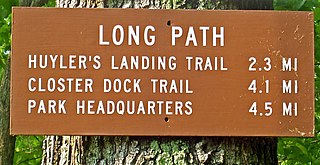
The Long Path is a 357-mile (575 km) long-distance hiking trail beginning in New York City, at the West 175th Street subway station near the George Washington Bridge and ending at Altamont, New York, in the Albany area. While not yet a continuous trail, relying on road walks in some areas, it nevertheless takes in many of the popular hiking attractions west of the Hudson River, such as the New Jersey Palisades, Harriman State Park, the Shawangunk Ridge and the Catskill Mountains. It offers hikers a diversity of environments to pass through, from suburbia and sea-level salt marshes along the Hudson to wilderness and boreal forest on Catskill summits 4,000 feet (1,220 m) in elevation.

The High Huts of the White Mountains are eight mountain huts in the White Mountains of New Hampshire, owned and maintained by the Appalachian Mountain Club. They are modeled after similar huts in the Alps and positioned at intervals along the Appalachian Trail, allowing "thru-hikers" who hike the entire Appalachian Trail to benefit from their services. They are generally separated by six to eight miles, about a day's hike.

Thru-hiking, or through-hiking, is the act of hiking an established long-distance trail end-to-end continuously.

Blood Mountain is the highest peak on the Georgia section of the Appalachian Trail and the sixth-tallest mountain in Georgia, with an elevation of 4,458 feet (1,359 m). It is located on the border of Lumpkin County with Union County and is within the boundaries of the Chattahoochee National Forest and the Blood Mountain Wilderness. There are several waterfalls, hiking trails and other recreational areas in the vicinity.
The Appalachian National Scenic Trail spans 14 U.S. states over its roughly 2,200 miles (3,500 km): Georgia, North Carolina, Tennessee, Virginia, West Virginia, Maryland, Pennsylvania, New Jersey, New York, Connecticut, Massachusetts, Vermont, New Hampshire, and Maine. The southern end is at Springer Mountain, Georgia, and it follows the ridgeline of the Appalachian Mountains, crossing many of its highest peaks and running almost continuously through wilderness before reaching the northern end at Mount Katahdin, Maine.

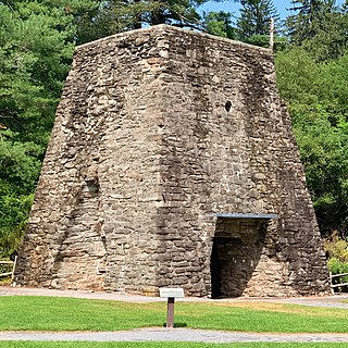
Pine Grove Furnace State Park is a protected Pennsylvania area that includes Laurel and Fuller Lakes in Cooke Township of Cumberland County. The Park accommodates various outdoor recreation activities, protects the remains of the Pine Grove Iron Works (1764), and was the site of Laurel Forge (1830), Pine Grove Park (1880s), and a brick plant (1892). The Park is 8 miles (13 km) from exit 37 of Interstate 81 on Pennsylvania Route 233.

The Sugarlands is a valley in the north-central Great Smoky Mountains, located in the Southeastern United States. Formerly home to a string of small Appalachian communities, the valley is now the location of the Great Smoky Mountains National Park headquarters and the Sugarlands Visitor Center. Lying just south of Gatlinburg, the Sugarlands is one of the park's most popular access points.
The Great Eastern Trail is a network of hiking trails forming a long-distance route in the eastern United States. North of Georgia, the route runs parallel to, and slightly to the west of, the Appalachian Trail. As of 2022, it is still under development and its current length is approximately 1,600 miles (2,600 km). Upon its completion the network is projected to be more than 2,000 miles (3,200 km) in length.

The Blue-Blazed Hiking Trail system, managed by the Connecticut Forest & Park Association (CFPA), and the related trail systems documented in the two volume 19th Edition of the "Connecticut Walk Book" comprise over 800 miles of hiking trails in Connecticut.

The Triple Crown of Hiking informally refers to the three major U.S. long-distance hiking trails:

The Appalachian Trail Museum is located in Pine Grove Furnace State Park near Gardners, Pennsylvania, United States, and commemorates the builders, maintainers and hikers of the Appalachian Trail, including those in the Appalachian Trail Hall of Fame. Features include a 1959 trail shelter from Peters Mountain built by Earl Shaffer, the first A.T. thru-hiker, vintage hiking and trail building equipment, historic A.T. signs, A.T. displays on permanent loan from the Smithsonian Institution, a recreation of A.T. founder Benton MacKaye's Sky Parlor office and a display on the National Trails System Act of 1968. The Museum also has an extensive research library.
Gene Espy is recognized as the second person to thru-hike the Appalachian Trail, making the entire 2,025-mile journey alone in one outing, covering 14 states in just over 123 days.

The Len Foote Hike Inn is a sustainably designed and LEED-certified ecotourism facility located near the peak of Frosty Mountain in the Chattahoochee National Forest in Dawson County, Georgia, USA. The lodge is open year-round and is only accessible via hiking trails. Twenty rooms, a two-story central lobby, a dining room, a bathhouse, toilets, and a common room comprise the facility.


