
Harvard Square is a triangular plaza at the intersection of Massachusetts Avenue, Brattle Street, and John F. Kennedy Street, near the center of Cambridge, Massachusetts, United States. The term "Harvard Square" is also used to delineate the business district and Harvard University surrounding that intersection, which is the historic center of Cambridge. Adjacent to Harvard Yard, the historic heart of Harvard University, the Square functions as a commercial center for Harvard students, as well as residents of western Cambridge and the inner western and northern suburbs of Boston. These residents use the Harvard station, a major MBTA Red Line subway and bus transportation hub.
Porter Square is a neighborhood in Cambridge and Somerville, Massachusetts in the USA, located around the intersection of Massachusetts Avenue and Somerville Avenue, between Harvard and Davis Squares. The Porter Square station serves both the MBTA Red Line and the Commuter Rail Fitchburg Line. A major part of the Lesley University campus is located within the Porter Square area.

The Longfellow Bridge is a steel rib arch bridge spanning the Charles River to connect Boston's Beacon Hill neighborhood with the Kendall Square area of Cambridge, Massachusetts. The bridge carries Massachusetts Route 3, the MBTA Red Line, bicycle, and pedestrian traffic. The structure was originally known as the Cambridge Bridge, and a predecessor structure was known as the West Boston Bridge; Boston also continued to use "West Boston Bridge" officially for the new bridge. The bridge is also known to locals as the "Salt-and-Pepper Bridge" due to the shape of its central towers.

Harvard is a rapid transit and bus transfer station in Cambridge, Massachusetts. Located at Harvard Square, it serves the MBTA's Red Line subway system as well as MBTA Buses. Harvard averaged 23,199 entries each weekday in 2013, making it the third-busiest MBTA station and the busiest outside the four downtown "hub" stations. Only Downtown Crossing and South Station handled more passengers. It is also an important transfer point, with subway, bus, and trackless trolley (trolleybus) service all connecting at the station. Five of the fifteen key MBTA bus routes, with one extended late-night service, stop at the station.
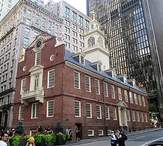
The Old State House is a historic building in Boston, Massachusetts, at the intersection of Washington and State Streets. Built in 1713, it was the seat of the Massachusetts General Court until 1798, and is one of the oldest public buildings in the United States. One of the landmarks on Boston's Freedom Trail, it is the oldest surviving public building in Boston, and now serves as a history museum operated by the Bostonian Society. It was designated a National Historic Landmark in 1960 and a Boston Landmark by the Boston Landmarks Commission in 1994.

The National Register of Historic Places in the United States is a register including buildings, sites, structures, districts, and objects. The Register automatically includes all National Historic Landmarks as well as all historic areas administered by the U.S. National Park Service. Since its introduction in 1966, more than 90,000 separate listings have been added to the register.

The Wren Building is the signature building of the College of William & Mary in Williamsburg, Virginia, USA. Along with the Brafferton and President's House, these buildings form the College's Ancient Campus. With a construction history dating to 1695, it is the oldest academic building in continuous use in the United States. It was designated a National Historic Landmark in 1960.

The Hooper–Lee–Nichols House is an historic Colonial American house in Cambridge, Massachusetts. Initially constructed in 1685 and enlarged and remodeled many times thereafter, it is located at 159 Brattle Street in Cambridge. It is the second-oldest house in the city. The house is now headquarters for the Cambridge Historical Society, which provides tours several times a week.
America's 11 Most Endangered Places or America's 11 Most Endangered Historic Places is a list of places in the United States that the National Trust for Historic Preservation considers the most endangered. It aims to inspire Americans to preserve examples of architectural and cultural heritage that could be "relegated to the dustbins of history" without intervention.

Storrow Drive, officially James Jackson Storrow Memorial Drive, is a major crosstown parkway in Boston, Massachusetts, running east–west along the southern bank of the Charles River. It is restricted to cars; trucks and buses are not permitted on it. Boston drivers use the route for quick access to downtown locations.

The Ada Covered Bridge is a 125-foot (38 m) span Brown truss covered bridge erected in 1867 in Ada, Michigan, United States. Carrying Bronson Street across the Thornapple River, it is located just south of where the Thornapple enters the Grand River, in turn just south of M-21. It is listed on the National Register of Historic Places.

This is a list of sites listed on the National Register of Historic Places in Cambridge, Massachusetts. This is intended to be a complete list of the properties and districts on the National Register of Historic Places in Cambridge, Massachusetts, United States. Latitude and longitude coordinates are provided for many National Register properties and districts; these locations may be seen together in an online map.
The Neponset Valley Parkway is a historic parkway in southern Boston and Milton, Massachusetts, United States. It is a connecting parkway in the Greater Boston area's network, providing a connection between the Blue Hills Reservation, Neponset River Reservation, and the Stony Brook Reservation. The parkway was constructed between 1898 and 1929 with design assistance from Charles Eliot and the Olmsted Brothers. It was listed on the National Register of Historic Places in 2005.

North Avenue Congregational Church is a historic church meetinghouse at 1801(previously at 1803) Massachusetts Avenue in Cambridge, Massachusetts. It was completely renovated in 2015 to become a library for Lesley University. The former church now forms part of what is now the Lunder Arts Center complex.

Fort Washington, also known as Fort Washington Park, is a historic site at 95 Waverly Street in Cambridge, Massachusetts. It was built by soldiers of the Continental Army under the orders of George Washington in November 1775. It is the oldest surviving fortification from the American Revolutionary War and the only surviving fortification from the Siege of Boston. Fort Washington was placed on the List of Registered Historic Places in Massachusetts on April 3, 1973.

Ware–Hardwick Covered Bridge is a historic covered bridge spanning the Ware River on Old Gilbertville Road and Bridge Street in Ware and Hardwick, Massachusetts. It is one of a small number of surviving 19th-century covered bridges in the state. The bridge was built in 1886, extensively rebuilt in 1986-1987, and was closed in 2002 due to structural issues and a limited carrying capacity. The bridge reopened in October 2010 and no longer has a weight limit according to MassDOT. It was listed on the National Register of Historic Places in 1986.

Hartwell and Richardson was a Boston, Massachusetts architectural firm established in 1881, by Henry Walker Hartwell (1833–1919) and William Cummings Richardson (1854–1935). The firm contributed significantly to the current building stock and architecture of the greater Boston area. Many of its buildings are listed on the National Register of Historic Places.

The Sachs Covered Bridge, also known as Sauck's Covered Bridge and Waterworks Covered Bridge, is a 100-foot (30 m), Town truss covered bridge over Marsh Creek between Cumberland and Freedom Townships, Adams County in the U.S. state of Pennsylvania. The bridge was also known as the Sauches Covered Bridge at the time of the Battle of Gettysburg. It was listed on the National Register of Historic Places in 1980.

Brattle Street in Cambridge, Massachusetts, called the "King's Highway" or "Tory Row" before the American Revolutionary War, is the site of many buildings of historic interest, including the modernist glass-and-concrete building that housed the Design Research store, and a Georgian mansion where George Washington and Henry Wadsworth Longfellow both lived Samuel Atkins Eliot, writing in 1913 about the seven Colonial mansions of Brattle Street's "Tory Row," called the area "not only one of the most beautiful but also one of the most historic streets in America." "As a fashionable address it is doubtful if any other residential street in this country has enjoyed such long and uninterrupted prestige."


