National Register of Historic Places listings in Methuen, Massachusetts
Last updated
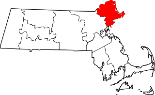
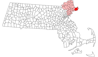
Location of Methuen in Massachusetts
This is intended to be a complete list of the properties and districts on the National Register of Historic Places in Methuen, Massachusetts, United States. The locations of National Register properties and districts for which the latitude and longitude coordinates are included below, may be seen in an online map.[1]
Essex County, of which Methuen is a part, is the location of 471 properties and districts listed on the National Register. Methuen itself is the location of 45 of these properties and districts.[2]
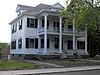
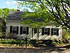
An imitation of Southern antebellum mansions, it is a well-conserved "country residence", one of several such houses built at the periphery of the Methuen settlement in the mid 19th century.
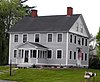
A well-preserved example of the inexpensive dwellings built by speculators for sale to woolen mill workers, a 1+1⁄2-story gable-roofed worker's cottage in the Arlington Mills Historic District,
This is a list of the National Register of Historic Places listings in Barnstable County, Massachusetts.
This list is of that portion of the National Register of Historic Places (NRHP) designated in Essex County, Massachusetts. The locations of these properties and districts for which the latitude and longitude coordinates are included below, may be seen in a map.
This is a list of the National Register of Historic Places listings in Hampden County, Massachusetts.
This is a list of the National Register of Historic Places listings in Suffolk County, Massachusetts.
This is a list of properties on the National Register of Historic Places in Hampshire County, Massachusetts.
This is a list of the National Register of Historic Places listings in Nantucket County, Massachusetts.
This is a list of the National Register of Historic Places listings in Dukes County, Massachusetts.
List of the National Register of Historic Places listings in Essex County, New York.
List of the National Register of Historic Places listings in Essex County, New Jersey
This is a list of sites listed on the National Register of Historic Places in Cambridge, Massachusetts. This is intended to be a complete list of the properties and districts on the National Register of Historic Places in Cambridge, Massachusetts, United States. Latitude and longitude coordinates are provided for many National Register properties and districts; these locations may be seen together in an online map.
This is a list of properties and historic districts in Somerville, Massachusetts, that have been listed on the National Register of Historic Places.
This is a list of properties and historic districts in Milton, Massachusetts, that are listed on the National Register of Historic Places.
This is a list of the National Register of Historic Places listings in Essex County, Virginia.
This is a list of the National Register of Historic Places listings in Andover, Massachusetts.
The following properties are listed on the National Register of Historic Places in Lawrence, Massachusetts.
This is a list of the National Register of Historic Places listings in Salem, Massachusetts.
This is a list of the National Register of Historic Places listings in Lynn, Massachusetts.
This is a list of the National Register of Historic Places listings in Gloucester, Massachusetts.
This is a list of the National Register of Historic Places listings in Ipswich, Massachusetts.
This is a list of the National Register of Historic Places listings in Cape Cod National Seashore.
References
↑ The latitude and longitude information provided in this table was derived originally from the National Register Information System, which has been found to be fairly accurate for about 99% of listings. Some locations in this table may have been corrected to current GPS standards.
↑ Numbers represent an alphabetical ordering by significant words. Various colorings, defined here, differentiate National Historic Landmarks and historic districts from other NRHP buildings, structures, sites or objects.
↑ The eight-digit number below each date is the number assigned to each location in the National Register Information System database, which can be viewed by clicking the number.
This page is based on this Wikipedia article Text is available under the CC BY-SA 4.0 license; additional terms may apply. Images, videos and audio are available under their respective licenses.