Waldenburg, Arkansas

Last updated

Waldenburg, Arkansas
Waldenburg AR 016.jpg
Waldenburg City Hall
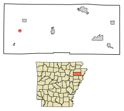
Poinsett County Arkansas Incorporated and Unincorporated areas Waldenburg Highlighted 0572320.svg
Location of Waldenburg in Poinsett County, Arkansas.
Coordinates: 35°33′55″N90°56′04″W / 35.56528°N 90.93444°W / 35.56528; -90.93444
Country United States
State Arkansas
County Poinsett
Area
[1]
  Total0.14 sq mi (0.35 km2)
  Land0.14 sq mi (0.35 km2)
  Water0.00 sq mi (0.00 km2)
Elevation
[2]
236 ft (72 m)
Population
 (2020)
  Total53
  Density389.71/sq mi (150.77/km2)
Time zone UTC-6 (Central (CST))
  Summer (DST) UTC-5 (CDT)
ZIP code
72475
Area code 870
FIPS code 05-72320
GNIS feature ID2406818 [2]

Waldenburg is a town in Poinsett County, Arkansas, United States. The population was 80 at the 2000 census. It is included in the Jonesboro, Arkansas Metropolitan Statistical Area. Waldenburg is home to Zion Lutheran Church. Zion was founded in 1881 and is a member congregation of the Lutheran Church–Missouri Synod. [3]

Contents

Geography

Zion Lutheran Church in Waldenburg. Zion's current building was built in the 1940s, right after World War II. Zion Lutheran Church (Waldenburg, AR).jpg
Zion Lutheran Church in Waldenburg. Zion's current building was built in the 1940s, right after World War II.

According to the United States Census Bureau, the town has a total area of 0.1 square miles (0.26 km2), all land.

Demographics

Historical population
CensusPop.Note
1960 113
1970 16445.1%
1980 124−24.4%
1990 103−16.9%
2000 80−22.3%
2010 61−23.7%
2020 53−13.1%
U.S. Decennial Census [4]

As of the census [5] of 2000, there were 80 people, 33 households, and 20 families residing in the town. The population density was 588.2 inhabitants per square mile (227.1/km2). There were 39 housing units at an average density of 286.7 per square mile (110.7/km2). The racial makeup of the town was 93.75% White, 5.00% Black or African American, and 1.25% from two or more races.

There were 33 households, out of which 27.3% had children under the age of 18 living with them, 54.5% were married couples living together, 6.1% had a female householder with no husband present, and 36.4% were non-families. 33.3% of all households were made up of individuals, and 3.0% had someone living alone who was 65 years of age or older. The average household size was 2.42 and the average family size was 3.19.

In the town, the population was spread out, with 23.8% under the age of 18, 10.0% from 18 to 24, 22.5% from 25 to 44, 32.5% from 45 to 64, and 11.3% who were 65 years of age or older. The median age was 39 years. For every 100 females, there were 110.5 males. For every 100 females age 18 and over, there were 134.6 males.

The median income for a household in the town was $23,750, and the median income for a family was $33,250. Males had a median income of $16,250 versus $16,250 for females. The per capita income for the town was $11,452. There were no families and 12.0% of the population living below the poverty line, including no under eighteens and 20.0% of those over 64.

Education

It is within the Harrisburg School District. It was formerly in the Weiner School District, [6] which consolidated into the Harrisburg district on July 1, 2010. [7]

Related Research Articles

<span class="mw-page-title-main">Poinsett County, Arkansas</span> County in Arkansas, United States

Poinsett County is a county located in the U.S. state of Arkansas. As of the 2020 census, the population was 22,965. The county seat is Harrisburg. Poinsett County is included in the Jonesboro–Paragould Combined Statistical Area.

<span class="mw-page-title-main">Briarcliff, Arkansas</span> City in Arkansas, United States

Briarcliff is a second-class city in Baxter County, Arkansas, United States. The population was 236 at the 2010 census.

<span class="mw-page-title-main">Greers Ferry, Arkansas</span> City in Arkansas, United States

Greers Ferry is a city in Cleburne County, Arkansas, United States. The population was 891 at the 2010 census. It was founded in 1968.

<span class="mw-page-title-main">Kingsland, Arkansas</span> City in Arkansas, United States

Kingsland, officially the City of Kingsland, is a small city in Cleveland County, south central Arkansas, United States. It is included in the Pine Bluff, Arkansas Metropolitan Statistical Area, and had a population of 447 at the 2010 U.S. census. It is known as the birthplace of musician Johnny Cash. His parents had a cotton farm there.

<span class="mw-page-title-main">Black Oak, Arkansas</span> Town in Arkansas, United States

Black Oak is a town in Craighead County, Arkansas, United States. The population was 262 at the 2010 census. It is included in the Jonesboro, Arkansas Metropolitan Statistical Area.

<span class="mw-page-title-main">Egypt, Arkansas</span> Town in Arkansas, United States

Egypt is a town in Craighead County, Arkansas, United States. The population was 112 at the 2010 census. It is included in the Jonesboro, Arkansas Metropolitan Statistical Area.

<span class="mw-page-title-main">Twin Groves, Arkansas</span> Town in Arkansas, United States

Twin Groves is a town in northwestern Faulkner County, Arkansas, United States. The name of the town comes from two neighboring communities — Solomon Grove and Zion Grove — which joined to incorporate as a town in 1991. The town's population was 335 at the 2010 census, up from 276 at the 2000 census. Twin Groves is part of the Central Arkansas region.

<span class="mw-page-title-main">Perla, Arkansas</span> Town in Arkansas, United States

Perla is a town in Hot Spring County, Arkansas, United States. The population was 241 at the 2010 census, up from 115 at the 2000 census. The city's water association filed for Chapter 9 Bankruptcy in the Western District of Arkansas Bankruptcy Court on May 26, 2019.

<span class="mw-page-title-main">Fisher, Arkansas</span> City in Arkansas, United States

Fisher is a city in Poinsett County, Arkansas, United States. The population was 223 at the 2010 census. It is included in the Jonesboro, Arkansas Metropolitan Statistical Area.

<span class="mw-page-title-main">Harrisburg, Arkansas</span> City in Arkansas, United States

Harrisburg is a city in Poinsett County, Arkansas, United States. The population was 2,212 at the 2020 census. It is included in the Jonesboro, Arkansas Metropolitan Statistical Area. The city is the county seat of Poinsett County.

<span class="mw-page-title-main">Lepanto, Arkansas</span> City in Arkansas, United States

Lepanto is a city in Poinsett County, Arkansas, United States. The population was 1,893 at the 2010 Census. It is included in the Jonesboro, Arkansas Metropolitan Statistical Area. The city is named for the Greek seaport of Lepanto, the site of a great sea battle in 1571.

<span class="mw-page-title-main">Tyronza, Arkansas</span> City in Arkansas, United States

Tyronza is a city in Poinsett County, Arkansas, United States. The population was 716 at the 2020 census. It is included in the Jonesboro, Arkansas Metropolitan Statistical Area and is in the Arkansas Delta.

<span class="mw-page-title-main">Weiner, Arkansas</span> City in Arkansas, United States

Weiner is a city in Poinsett County, Arkansas, United States. The population was 716 at the 2010 census. It is included in the Jonesboro, Arkansas Metropolitan Statistical Area.

<span class="mw-page-title-main">Longtown, Missouri</span> Village in Missouri, United States

Longtown is a village in Union Township in Perry County, Missouri, United States. The population was 90 at the 2020 census.

<span class="mw-page-title-main">Blue Eye, Missouri</span> Town in Missouri, United States

Blue Eye is a town in Stone County, Missouri, United States. The population was 289 at the 2020 census. The population estimate is 389 as of 2022. It is part of the Branson Micropolitan Statistical Area. Blue Eye, Missouri is adjacent to Blue Eye, Arkansas.

<span class="mw-page-title-main">McKey, Oklahoma</span> CDP in Oklahoma, United States

McKey is a census-designated place (CDP) in Sequoyah County, Oklahoma, United States. It is part of the Fort Smith, Arkansas-Oklahoma Metropolitan Statistical Area. The population was 135 at the 2000 census. McKey was established on the Old Osage and Arkansas Valley Railroad near MacKey's Salt Works. The post office existed from March 13, 1891, until July 14, 1928.

<span class="mw-page-title-main">Davy, West Virginia</span> Town in West Virginia, United States

Davy is a town in McDowell County, West Virginia, United States. The population was 420 at the 2010 census. Founded in 1873, the town was originally called Hallsville but the name would change to Davy by 1901. Davy was officially incorporated in 1948. It is a mostly residential community in a coal mining district along the main line of the Norfolk Southern Railway.

Foster is a town in Clark County in the U.S. state of Wisconsin. The population was 95 at the 2010 census, unchanged from the 2000 census.

<span class="mw-page-title-main">Hartland, Wisconsin</span> Village in Wisconsin, United States

Hartland is a village along the Bark River in Waukesha County, Wisconsin, United States, that is a suburb of Milwaukee. The population was 9,501 at the 2020 census.

<span class="mw-page-title-main">Newman Grove, Nebraska</span> City in Platte County, Nebraska, United States

Newman Grove is a city in Madison and Platte counties in Nebraska, United States. The population was 721 at the 2010 census.

References

  1. "2020 U.S. Gazetteer Files". United States Census Bureau. Retrieved October 29, 2021.
  2. 1 2 U.S. Geological Survey Geographic Names Information System: Waldenburg, Arkansas
  3. "Find a Church, School, Worker".
  4. "Census of Population and Housing". Census.gov. Retrieved June 4, 2015.
  5. "U.S. Census website". United States Census Bureau . Retrieved January 31, 2008.
  6. "SCHOOL DISTRICT REFERENCE MAP (2010 CENSUS): Poinsett County, AR" (PDF). U.S. Census Bureau . Retrieved March 4, 2021.
  7. "Consolidation/Annexations of LEA's (1983-June 30, 2012)." Arkansas Department of Education. Retrieved on July 31, 2017.