
Ross-on-Wye is a market town and civil parish in Herefordshire, England, near the border with Wales. It had a population estimated at 10,978 in 2021. It lies in south-east of the county, on the River Wye and on the northern edge of the Forest of Dean.

Weston under Penyard is a small village in Herefordshire, England. The population of the civil parish at the 2011 Census was 1,007.

Goodrich is a village in south Herefordshire, England close to Gloucestershire and the Forest of Dean, situated near the River Wye at grid reference SO574193. It is known for its Norman and mediaeval castle built with Old Red Sandstone.

Welsh Bicknor is an area in the far south of the English county of Herefordshire. Despite its name, it is not now in Wales, but it was historically a detached parish (exclave) of the county of Monmouthshire. It lies within a loop of the River Wye and covers 8,502 acres (13.3 sq mi).

Ganarew is a village and small civil parish in south Herefordshire, England near the River Wye and the border with Wales. The village is located 0.62 miles (1.00 km) southwest of the village of Whitchurch on the main A40 road, and lies within the electoral ward of Kerne Bridge. The village is about 2 miles (3.2 km) from Monmouth and 8 miles (13 km) from Ross-on-Wye. It contains the Church of St Swithin and Ganarew Manor.
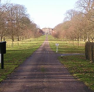
Hill Court Manor is a country house built in 1700 at Hom Green, Walford near Ross-on-Wye in Herefordshire. The house is a Grade I listed building. It is currently owned and occupied by the Rehau Group.
Kerne Bridge is a hamlet in south Herefordshire, England, about 3.5 miles (6 km) south of the market town of Ross-on-Wye on the B4234 Ross-on-Wye to Coleford road. Situated on the left bank of the River Wye, it takes its modern name from the nineteenth century bridge over the river. It was once a significant stop on the now disused and abandoned Monmouth to Ross-on-Wye railway, and is now known for a popular canoe-launching site. It marks the northern start of the Upper Wye Gorge and is situated in the heart of the Wye Valley Area of Outstanding Natural Beauty.

Lydbrook is a civil parish in the Forest of Dean, a local government district in the English county of Gloucestershire and is located in the Wye Valley. It is on the north west edge of the Forest of Dean's present legal boundary proper. It comprises the districts of Lower Lydbrook, Upper Lydbrook, Joys Green and Worrall Hill. It has a mile and a half long high street, reputed to be the longest high street of any village in England.
Coppet Hill or Coppett Hill is a local nature reserve in the parish of Goodrich near Ross-on-Wye in Herefordshire.

The Wye Valley Railway was a standard gauge railway that ran for nearly 15 miles (24 km) along the Lower Wye Valley between the towns of Chepstow and Monmouth, crossing several times between Wales and England. Opened on 1 November 1876, it was leased to, and worked by, the Great Western Railway (GWR), before being fully absorbed by the GWR in 1905.

The Hereford, Ross and Gloucester Railway was a railway which ran for 22+1⁄2 miles (36.2 km) linking Hereford and Gloucester, England, via Ross-on-Wye. It was opened on 1 June 1855 as a 7 ft 1⁄4 in broad gauge line, it was amalgamated with the Great Western Railway in 1862. In 1869 the railway was converted to 4 ft 8+1⁄2 in standard gauge. The railway was closed to passengers on 2 November 1964, freight services between Ross-on-Wye railway station and Grange Court railway station continued on until 1 November 1965.
The Ross and Monmouth Railway was a standard gauge railway of 13 miles (21 km) which ran between Ross-on-Wye, in Herefordshire, England and Monmouth, Wales.
Lydbrook Junction railway station is a disused railway station in England opened by the Ross and Monmouth Railway in 1873, it remained open for 91 years until 1964 when the line finally closed to freight, though passenger services ceased in 1959. The station was constructed in the hamlet of Stowfield approximately half a mile from Lydbrook and its viaduct on the Severn and Wye Railway. It was located approximately 4 miles and 34 chains along the railway from Ross-on-Wye station. In 1874 the Severn and Wye Railway opened a branch from Serridge Junction and Cinderford, passenger services commenced in 1875. All passenger trains along the S&W branch were withdrawn from 1929.

Kerne Bridge railway station is a disused railway station on the Ross and Monmouth Railway constructed in the Herefordshire hamlet of Kerne Bridge which also served the village of Goodrich across the River Wye.
Walford Halt railway station is a disused halt on the Ross and Monmouth Railway constructed near the Herefordshire village of Walford. It also served the surrounding settlements. Nothing remains of the station. It was located approximately 3 miles and 12 chains along the railway from Ross-on-Wye station.

Bridstow is a village and civil parish in Herefordshire, England, 2 km west of Ross-on-Wye and 17 km south-east of Hereford. The parish is bounded to the east and south by the River Wye. The A40 road linking the M50 motorway to South Wales runs through the parish, crossing the Wye at Bridstow Bridge. The parish had a population of 906 in the 2011 UK census, and an estimated population of 941 in 2018.
Llangrove is a small village in the civil parish of Llangarron in southwest Herefordshire within seven miles of Ross-on-Wye and Monmouth.

Marstow is a hamlet and civil parish in south eastern Herefordshire, England. Most of the parish is within the Wye Valley Area of Outstanding Natural Beauty.

Kerne Bridge was built over the River Wye in the County of Herefordshire, England in 1825–28, on the site of an ancient ford crossing known as Flanesford. It is designated as a Scheduled Monument. Carrying the B4229 road, it connects the parishes of Walford on the river's left bank and Goodrich on the right. It is situated in the heart of the Wye Valley Area of Outstanding Natural Beauty and marks the northern end of the Upper Wye Gorge.

Dry Arch Bridge in Goodrich, Herefordshire, England, built in 1828, is one of the earliest examples of a bridge built specifically to carry a minor road across a more major one without the need for a road junction. It was constructed to carry the existing old road between Goodrich and Welsh Bicknor over a cutting for a new-built road connecting Kerne Bridge with Goodrich. It was built with a single span, using local sandstone, at least some of which came from the cutting beneath the bridge. It was also constructed to allow pedestrians to cross from one road to the other three-dimensionally without a lengthy diversion.

