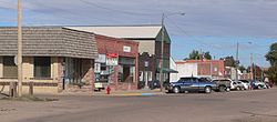
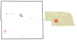
Wallace, Nebraska

Last updated

Wallace, Nebraska
Wallace, Nebraska downtown 1.jpg
Downtown Wallace
Lincoln County Nebraska Incorporated and Unincorporated areas Wallace Highlighted.svg
Location of Wallace, Nebraska
Coordinates: 40°50′15″N101°09′52″W / 40.83750°N 101.16444°W / 40.83750; -101.16444
Country United States
State Nebraska
County Lincoln
Area
[1]
  Total0.71 sq mi (1.84 km2)
  Land0.71 sq mi (1.84 km2)
  Water0.00 sq mi (0.00 km2)
Elevation
[2]
3,110 ft (950 m)
Population
 (2020)
  Total318
  Density447.26/sq mi (172.58/km2)
Time zone UTC-6 (Central (CST))
  Summer (DST) UTC-5 (CDT)
ZIP code
69169
Area code 308
FIPS code 31-51175 [3]
GNIS feature ID2400086 [2]

Wallace is a village in Lincoln County, Nebraska, United States. It is part of the North Platte, Nebraska Micropolitan Statistical Area. The population was 366 at the 2010 census.

Contents

History

When the railroad was extended in 1887 Wallace was platted. [4]

Geography

According to the United States Census Bureau, the village has a total area of 0.71 square miles (1.84 km2), all land. [5]

Climate

Climate data for Wallace 2W, Nebraska (1991–2020 normals, extremes 1962–present)
MonthJanFebMarAprMayJunJulAugSepOctNovDecYear
Record high °F (°C)75
(24)
78
(26)
89
(32)
94
(34)
101
(38)
109
(43)
110
(43)
108
(42)
106
(41)
94
(34)
85
(29)
82
(28)
110
(43)
Mean maximum °F (°C)61.7
(16.5)
66.7
(19.3)
78.2
(25.7)
85.3
(29.6)
91.9
(33.3)
98.1
(36.7)
101.7
(38.7)
98.9
(37.2)
95.7
(35.4)
87.0
(30.6)
74.6
(23.7)
63.8
(17.7)
103.1
(39.5)
Mean daily maximum °F (°C)39.3
(4.1)
42.2
(5.7)
52.9
(11.6)
61.5
(16.4)
71.5
(21.9)
83.2
(28.4)
89.0
(31.7)
86.8
(30.4)
79.0
(26.1)
65.3
(18.5)
51.5
(10.8)
41.0
(5.0)
63.6
(17.6)
Daily mean °F (°C)26.2
(−3.2)
28.7
(−1.8)
38.1
(3.4)
46.7
(8.2)
57.9
(14.4)
69.1
(20.6)
74.6
(23.7)
72.2
(22.3)
63.2
(17.3)
49.6
(9.8)
37.2
(2.9)
27.6
(−2.4)
49.3
(9.6)
Mean daily minimum °F (°C)13.0
(−10.6)
15.2
(−9.3)
25.3
(−3.7)
32.0
(0.0)
44.2
(6.8)
55.1
(12.8)
60.3
(15.7)
57.5
(14.2)
47.3
(8.5)
33.8
(1.0)
22.9
(−5.1)
14.2
(−9.9)
34.9
(1.6)
Mean minimum °F (°C)−7.3
(−21.8)
−4.4
(−20.2)
5.1
(−14.9)
18.1
(−7.7)
29.9
(−1.2)
43.8
(6.6)
50.8
(10.4)
47.9
(8.8)
34.1
(1.2)
18.3
(−7.6)
6.6
(−14.1)
−3.7
(−19.8)
−13.5
(−25.3)
Record low °F (°C)−26
(−32)
−28
(−33)
−19
(−28)
3
(−16)
19
(−7)
31
(−1)
40
(4)
35
(2)
15
(−9)
0
(−18)
−20
(−29)
−33
(−36)
−33
(−36)
Average precipitation inches (mm)0.30
(7.6)
0.56
(14)
0.88
(22)
2.22
(56)
3.47
(88)
3.83
(97)
3.24
(82)
2.65
(67)
1.56
(40)
1.66
(42)
0.51
(13)
0.49
(12)
21.37
(543)
Average snowfall inches (cm)3.4
(8.6)
5.6
(14)
3.1
(7.9)
3.2
(8.1)
0.1
(0.25)
0.0
(0.0)
0.0
(0.0)
0.0
(0.0)
0.0
(0.0)
1.5
(3.8)
2.4
(6.1)
2.7
(6.9)
22.0
(56)
Average precipitation days (≥ 0.01 in)2.94.05.27.710.39.68.16.85.55.73.23.072.0
Average snowy days (≥ 0.1 in)2.43.12.41.40.10.00.00.00.00.71.62.314.0
Source: NOAA [6] [7]

Demographics

Historical population
CensusPop.Note
1900 130
1910 17534.6%
1920 32786.9%
1930 40624.2%
1940 335−17.5%
1950 3617.8%
1960 293−18.8%
1970 241−17.7%
1980 34944.8%
1990 308−11.7%
2000 3296.8%
2010 36611.2%
2020 318−13.1%
U.S. Decennial Census [8]

2010 census

As of the census [9] of 2010, there were 366 people, 140 households, and 104 families residing in the village. The population density was 515.5 inhabitants per square mile (199.0/km2). There were 152 housing units at an average density of 214.1 per square mile (82.7/km2). The racial makeup of the village was 85.5% White, 1.1% Native American, 0.8% Asian, 10.4% from other races, and 2.2% from two or more races. Hispanic or Latino of any race were 17.2% of the population.

There were 140 households, of which 40.7% had children under the age of 18 living with them, 61.4% were married couples living together, 7.1% had a female householder with no husband present, 5.7% had a male householder with no wife present, and 25.7% were non-families. 22.1% of all households were made up of individuals, and 10% had someone living alone who was 65 years of age or older. The average household size was 2.61 and the average family size was 3.09.

The median age in the village was 35.8 years. 30.9% of residents were under the age of 18; 5.2% were between the ages of 18 and 24; 23.2% were from 25 to 44; 24.8% were from 45 to 64; and 15.8% were 65 years of age or older. The gender makeup of the village was 47.0% male and 53.0% female.

2000 census

As of the census [3] of 2000, there were 329 people, 134 households, and 97 families residing in the village. The population density was 467.5 inhabitants per square mile (180.5/km2). There were 145 housing units at an average density of 206.0 per square mile (79.5/km2). The racial makeup of the village was 99.39% White, 0.30% Native American, 0.30% from other races. Hispanic or Latino of any race were 0.61% of the population.

There were 134 households, out of which 32.8% had children under the age of 18 living with them, 64.2% were married couples living together, 3.7% had a female householder with no husband present, and 26.9% were non-families. 26.1% of all households were made up of individuals, and 11.9% had someone living alone who was 65 years of age or older. The average household size was 2.46 and the average family size was 2.95.

In the village, the population was spread out, with 28.9% under the age of 18, 4.6% from 18 to 24, 22.2% from 25 to 44, 24.3% from 45 to 64, and 20.1% who were 65 years of age or older. The median age was 42 years. For every 100 females, there were 86.9 males. For every 100 females age 18 and over, there were 98.3 males.

As of 2000 the median income for a household in the village was $36,771, and the median income for a family was $41,346. Males had a median income of $30,179 versus $19,688 for females. The per capita income for the village was $22,033. About 6.4% of families and 9.5% of the population were below the poverty line, including 18.3% of those under age 18 and none of those age 65 or over.

Local business

Related Research Articles

<span class="mw-page-title-main">Cedar Creek, Nebraska</span> Village in Nebraska, United States

Cedar Creek is a village in Cass County, Nebraska, United States. The population was 465 at the 2020 census.

<span class="mw-page-title-main">Eagle, Nebraska</span> Village in Nebraska, United States

Eagle is a village in southwest Cass County, Nebraska, United States. As of the 2020 census, the village population was 1,065.

<span class="mw-page-title-main">Elmwood, Nebraska</span> Village in Nebraska, United States

Elmwood is a village in southeast Cass County, Nebraska, United States. The population was 654 at the 2020 census.

<span class="mw-page-title-main">Manley, Nebraska</span> Village in Nebraska, United States

Manley is a village in Cass County, Nebraska, United States. The population was 167 at the 2020 census.

<span class="mw-page-title-main">Anselmo, Nebraska</span> Village in Custer County, Nebraska, United States

Anselmo is a village in Custer County, Nebraska, United States. The population was 145 at the 2010 census.

<span class="mw-page-title-main">Overton, Nebraska</span> Village in Nebraska, United States

Overton is a village in Dawson County, Nebraska, United States. It is part of the Lexington, Nebraska Micropolitan Statistical Area. The population was 594 at the 2010 census.

<span class="mw-page-title-main">Boys Town, Nebraska</span> Village in Douglas County, Nebraska, United States

Boys Town is a village in Douglas County, Nebraska, United States. The population was 410 at the 2020 census. Boys Town is an enclave and a suburb of Omaha.

<span class="mw-page-title-main">Waterloo, Nebraska</span> Village in Douglas County, Nebraska, United States

Waterloo is a village in Douglas County, Nebraska, United States. The population was 935 at the 2020 census.

<span class="mw-page-title-main">Chambers, Nebraska</span> Village in Nebraska, United States

Chambers is a village in Holt County, Nebraska, United States. The population was 268 at the 2010 census.

<span class="mw-page-title-main">Stuart, Nebraska</span> Village in Nebraska, United States

Stuart is a village in Holt County, Nebraska, United States. The population was 590 at the 2010 census.

<span class="mw-page-title-main">Stapleton, Nebraska</span> Village in and county seat of Logan County, Nebraska, United States

Stapleton is a village in and the county seat of Logan County, Nebraska, United States. The population was 267 at the 2020 census.

<span class="mw-page-title-main">Ithaca, Nebraska</span> Village in Saunders County, Nebraska, United States

Ithaca is a village in Saunders County, Nebraska, United States. The population was 160 at the 2020 census.

<span class="mw-page-title-main">Malmo, Nebraska</span> Village in Saunders County, Nebraska, United States

Malmo is a village in Saunders County, Nebraska, United States. The population was 94 at the 2020 census.

<span class="mw-page-title-main">Memphis, Nebraska</span> Village in Nebraska, United States

Memphis is a village in Saunders County, Nebraska, United States. The population was 109 at the 2020 census.

<span class="mw-page-title-main">Morse Bluff, Nebraska</span> Village in Saunders County, Nebraska, United States

Morse Bluff is a village in Saunders County, Nebraska, United States. The population was 117 at the 2020 census.

<span class="mw-page-title-main">Weston, Nebraska</span> Village in Saunder County, Nebraska, United States

Weston is a village in Saunders County, Nebraska, United States. The population was 250 at the 2020 census.

<span class="mw-page-title-main">Staplehurst, Nebraska</span> Village in Seward County, Nebraska, United States

Staplehurst is a village in Seward County, Nebraska, United States. It is part of the Lincoln, Nebraska Metropolitan Statistical Area. The population was 242 at the 2010 census.

<span class="mw-page-title-main">Herman, Nebraska</span> Village in Washington County, Nebraska, United States

Herman is a village in Washington County, Nebraska, United States. The population was 268 at the 2010 census.

<span class="mw-page-title-main">Washington, Nebraska</span> Village in Washington County, Nebraska, United States

Washington is a village in Washington County, Nebraska, United States. The population was 150 at the 2010 census.

<span class="mw-page-title-main">Bartlett, Nebraska</span> Village in and county seat of Wheeler County, Nebraska, United States

Bartlett is a village in, and the county seat of, Wheeler County, Nebraska, United States. The population was 117 at the 2010 census.

References

  1. "ArcGIS REST Services Directory". United States Census Bureau. Retrieved September 18, 2022.
  2. 1 2 U.S. Geological Survey Geographic Names Information System: Wallace, Nebraska
  3. 1 2 "U.S. Census website". United States Census Bureau . Retrieved January 31, 2008.
  4. "Wallace, Lincoln County". Center for Advanced Land Management Information Technologies. University of Nebraska. Retrieved August 19, 2014.
  5. "US Gazetteer files 2010". United States Census Bureau . Retrieved June 24, 2012.
  6. "NOWData - NOAA Online Weather Data". National Oceanic and Atmospheric Administration. Retrieved December 10, 2021.
  7. "Station: Wallace 2W, NE". U.S. Climate Normals 2020: U.S. Monthly Climate Normals (1991-2020). National Oceanic and Atmospheric Administration. Retrieved December 10, 2021.
  8. "Census of Population and Housing". Census.gov. Retrieved June 4, 2015.
  9. "U.S. Census website". United States Census Bureau . Retrieved June 24, 2012.
  10. "1st State Bank Locations". 1st.BANK. 2019.