
Omaha is the largest city in the state of Nebraska and the county seat of Douglas County. Omaha is in the Midwestern United States on the Missouri River, about 10 miles (15 km) north of the mouth of the Platte River. The nation's 40th-largest city, Omaha's 2018 estimated population was 466,061.
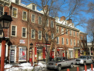
Society Hill is a historic neighborhood in Center City Philadelphia, Pennsylvania with a population of 6,215 as of the 2010 United States Census. Settled in the early 1680s, Society Hill is one of the oldest residential neighborhoods in Philadelphia. After urban decay developed between the late 19th and early 20th centuries, an urban renewal program began in the 1950s, restoring the area and its many historic buildings. Society Hill has since become one of the most expensive neighborhoods with the highest average income and second highest real estate values in Philadelphia. Society Hill's historic colonial architecture, along with intelligent planning and restoration efforts, led the American Planning Association to designate it, in 2008, as one of the great American neighborhoods and a good example of sustainable urban living.

North Omaha is a community area in Omaha, Nebraska, in the United States. It is bordered by Cuming and Dodge Streets on the south, Interstate 680 on the north, North 72nd Street on the west and the Missouri River and Carter Lake, Iowa on the east, as defined by the University of Nebraska at Omaha and the Omaha Chamber of Commerce.
Significant events in the history of North Omaha, Nebraska include the Pawnee, Otoe and Sioux nations; the African American community; Irish, Czech, and other European immigrants, and; several other populations. Several important settlements and towns were built in the area, as well as important social events that shaped the future of Omaha and the history of the nation. The timeline of North Omaha history extends to present, including recent controversy over schools.

The history of Omaha, Nebraska began before the settlement of the city, with speculators from neighboring Council Bluffs, Iowa staking land across the Missouri River illegally as early as the 1840s. When it was legal to claim land in Indian Country, William D. Brown was operating the Lone Tree Ferry to bring settlers from Council Bluffs to Omaha. A treaty with the Omaha Tribe allowed the creation of the Nebraska Territory, and Omaha City was founded on July 4, 1854. With early settlement came claim jumpers and squatters, and the formation of a vigilante law group called the Omaha Claim Club, which was one of many claim clubs across the Midwest. During this period many of the city's founding fathers received lots in Scriptown, which was made possible by the actions of the Omaha Claim Club. The club's violent actions led to the U.S. Supreme Court trial, Baker v. Morton, which led to the end of the organization.
Education in Omaha, Nebraska is provided by many private and public institutions. The first high school graduates in the Omaha area came from Brownell-Talbot School, which was founded in the town of Saratoga in 1863. The oldest school building in continuous usage is Omaha Central High School.
The neighborhoods of Omaha are a diverse collection of community areas and specific enclaves. They are spread throughout the Omaha metro area, and are all on the Nebraska side of the Missouri River.

Midtown is a geographic area of Omaha, Nebraska that is a culturally, socially and economically important area of the city. It is home to major research centers, national corporations, several historic districts, and a number of historic residences.
The Kountze Place neighborhood of Omaha, Nebraska is a historically significant community on the city's north end. Today the neighborhood is home to several buildings and homes listed on the National Register of Historic Places. It is located between North 16th Avenue on the east to North 30th Street on the west; Locust Street on the south to Pratt Street on the north. Kountze Place was annexed into Omaha in 1887. The neighborhood was built as a suburban middle and upper middle class enclave for doctors, lawyers, successful businessmen and other professional workers.

The Minne Lusa Residential Historic District is located in North Omaha, Nebraska. It is included on the National Register of Historic Places. According to the National Park Service, it is an "example of a substantial, affordable single-family residential development within the city limits that was platted, developed and constructed by a single firm between 1915 and 1941." The neighborhood is filled with bungalows, Craftsman, and other styles that were popular in the era. There are 540 properties in the neighborhood that contribute to the historic district, the other 167 do not. Minne Lusa Boulevard is a contributing structure.
Walnut Hill is a historic neighborhood located in north Omaha, Nebraska. It is bounded by North 40th Street on the east, Cuming Street on the south, Northwest Radial Highway and Saddle Creek Road on the west and Hamilton Street on the north.

Jobbers Canyon Historic District was a large industrial and warehouse area comprising 24 buildings located in downtown Omaha, Nebraska, USA. It was roughly bound by Farnam Street on the north, South Eighth Street on the east, Jackson Street on the south, and South Tenth Street on the west. In 1989, all 24 buildings in Jobbers Canyon were demolished, representing the largest National Register historic district loss to date.

The Dr. Samuel D. Mercer House was built in 1885 at 3920 Cuming Street in the historic Walnut Hill neighborhood of Omaha, Nebraska, United States. Samuel Mercer was the chief surgeon of the Union Pacific Railroad, and the founder of Omaha's first hospital.
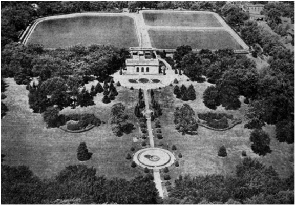
The Florence Water Works is located along John J. Pershing Drive in the Florence neighborhood of Omaha, Nebraska. Home of the Minne Lusa Pumping Station, the Water Works has provided water throughout the city of Omaha since 1880.
The Omaha and Council Bluffs Railway and Bridge Company, known as O&CB, was incorporated in 1886 in order to connect Omaha, Nebraska with Council Bluffs, Iowa over the Missouri River. With a sanctioned monopoly over streetcar service in the two cities, the O&CB was among the earliest major electric street railway systems in the nation, and was one of the last streetcar operators in the U.S., making its last run in 1955.

The Burlington Headquarters Building, also called Burlington Place, is located at 1004 Farnam Street in Downtown Omaha, Nebraska. This four-story brick building was originally designed by Alfred R. Dufrene and built in 1879 next to Jobbers Canyon. It was redesigned by noted Omaha architect Thomas R. Kimball in 1899, and vacated by the railroad in 1966. The building was listed on the National Register of Historic Places in 1974, designated an Omaha Landmark in 1978, and rehabilitated in 1983. Today it is office space.
Mendelssohn, Fisher and Lawrie was a significant architecture firm in early Omaha, Nebraska. Fisher & Lawrie continued. A number of their works are listed on the National Register of Historic Places.
The Minne Lusa Pumping Station was located along John J. Pershing Drive in the Florence neighborhood of North Omaha, Nebraska. The station, which was surrounded by settling basins, was the main source for pumping, filtering, and distributing Missouri River water throughout the City of Omaha. The station was the namesake of the Minne Lusa neighborhood located immediately to the south.
Significant events in the history of Omaha, Nebraska, include social, political, cultural, and economic activities.
Rocheford & Gould were brick manufacturers and construction contractors in early Omaha, Nebraska. The firm built numerous brick structures during Omaha's transition from the wooden buildings of Nebraska's territorial days to more permanent structures. The buildings the firm built included breweries, schools, packing houses, business blocks, Vaudeville theaters, street car barns and power houses, and civic buildings. Many of the structures the firm built have been demolished but a few of their earliest structures still exist and are listed on the National Register of Historic Places.
