Related Research Articles

Chesterfield is a market and industrial town in the ceremonial county of Derbyshire, England. It is 24 miles (39 km) north of Derby and 11 miles (18 km) south of Sheffield at the confluence of the Rivers Rother and Hipper. In 2011, the built-up-area subdivision had a population of 88,483, making it the second-largest settlement in Derbyshire, after Derby. The wider Borough of Chesterfield had a population of 103,569 in the 2021 Census. In 2021, the town itself had a population of 76,402.

Sheffield Manor Lodge, also known as Sheffield Manor or locally as Manor Castle, is a lodge built about 1516 in what then was a large deer park southeast of Sheffield, South Yorkshire, England, to provide a country retreat and further accommodate George Talbot, the 4th Earl of Shrewsbury, and his large family. The remnant of this estate is now known as Norfolk Park. The housing estate of Manor is named after Sheffield Manor Lodge.

Tapton House, in Tapton, Derbyshire, England, was once the home of engineer George Stephenson, who built the first public railway line in the world to use steam locomotives. Tapton has been a gentleman's residence, a ladies' boarding school and a co-educational school.
Wingfield Manor is a ruined manor house left deserted since the 1770s, near the village of South Wingfield and some four miles (6.4 km) west of the town of Alfreton in the English county of Derbyshire. There is a working farm that forms part of the old manor.

Tutbury Castle is a largely ruined medieval castle at Tutbury, Staffordshire, England, in the ownership of the Duchy of Lancaster and hence currently of King Charles III. It is a scheduled monument and a Grade I listed building. People who have stayed in the castle include Eleanor of Aquitaine and Mary, Queen of Scots, who was a prisoner there.
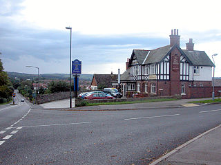
Walton is a suburb of Chesterfield, in the Chesterfield district, in the county of Derbyshire, England. Walton extends into the neighbouring North East Derbyshire district, with a small portion centred around the Acorn Ridge road and St. John's church within the Holymoorside and Walton civil parish. The population of the appropriate Chesterfield ward taken at the 2011 Census was 2,489.

Brimington is a large village and civil parish in the Borough of Chesterfield in Derbyshire, England. The population of the parish taken at the 2011 census was 8,788. The town of Staveley is to the east, and Hollingwood is nearby. The parish includes Brimington Common along the Calow Road, and New Brimington, a late 19th-century extension towards the Staveley Iron Works.

Chartley Castle lies in ruins to the north of the village of Stowe-by-Chartley in Staffordshire, between Stafford and Uttoxeter. Mary, Queen of Scots, was imprisoned on the estate in 1585. The remains of the castle and associated earthworks are a Scheduled Monument, the site having been protected since 1925. The castle itself is a Grade II* listed building

Holymoorside is a village in the civil parish of Holymoorside and Walton, in the North East Derbyshire district, in the county of Derbyshire, England, approximately two miles west of Chesterfield. It is located at 53.21 North, -1.49 West. Close to the boundary of the Peak District National Park, Chatsworth House lies seven miles to the west of the village. In 2020 it had an estimated population of 1,419.

Chatsworth is a civil parish in Derbyshire, England, within the area of the Derbyshire Dales and the Peak District National Park.

The River Hipper is a tributary of the River Rother in Derbyshire, England. Its source is a large expanse of wetlands, fed by the surrounding moors between Chatsworth and Chesterfield, known as the Hipper Sick on Beeley Moor, which is part of the Chatsworth Estate. It then passes through Holymoorside and down into Chesterfield, just south of the town centre, before flowing into the River Rother. In July 2007, parts of Chesterfield flooded when the River Hipper burst its banks during a substantial storm that caused extensive flooding in North Derbyshire and South Yorkshire. The river burst its banks again after torrential rain in October 2023. The surrounding landscape is known as the Hipper Valley.
Sir Francis Foljambe, 1st Baronet was Member of Parliament for Pontefract in 1626 and High Sheriff of Derbyshire in 1633.

Hassop Hall is a 17th-century country house near Bakewell, Derbyshire, which was operated as a hotel until it closed on 29 September 2019. It is a Grade II* listed building.
Somersall Hall is a small country house near Brampton, Chesterfield, Derbyshire. It is a Grade II listed building.

Melbourne Castle was a medieval castle in Melbourne, Derbyshire. It was built on the site of an earlier royal manor house that had provided accommodation for noblemen hunting in a nearby royal park in the reign of King John. Construction of the castle was started in 1311 by Thomas, 2nd Earl of Lancaster, and continued until 1322, shortly before his execution, but the work was never fully completed.
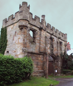
Mackworth Castle was a 14th- or 15th-century structure located in Derbyshire, at the upper end of Mackworth village near Derby. The home for several centuries of the Mackworth family, it was at some point reduced to the ruins of a gatehouse suggestive of a grand castle. A survey from 1911 suggested that though the gatehouse resembled a castle, the rest of the structure may have been more modest. The remains are part of a designated Scheduled Ancient Monument.

Withcote is a small parish currently comprising a number of scattered dwellings in Harborough, a local government district of Leicestershire. The population is included in the civil parish of Braunston-in-Rutland.

Sir Godfrey de Foljambe was a prominent landowner and politician in fourteenth-century England, who was a Baron of the Exchequer and chief steward of the duchy of Lancaster. He went on to have a successful career as an Irish judge, including three years as Lord Chief Justice of Ireland. He was initially a servant of Philippa of Hainault before becoming a prominent member of the affinity of her son, John of Gaunt, Duke of Lancaster. His tomb can still be seen at All Saints Church, Bakewell.
The Baronetcy of Foljambe of Walton was created in the Baronetage of England on 24 July 1622 for Francis Foljambe of Walton Hall, Walton, near Chesterfield, Derbyshire, who was later Member of Parliament for Pontefract in 1626 and High Sheriff of Derbyshire in 1633.

Holymoorside and Walton is a civil parish within the North East Derbyshire district, which is in the county of Derbyshire, England. Named for its main settlements, with a mix of a number of villages and hamlets amongst a large rural area, it had a population of 2,138 residents in 2021. The parish is 130 miles (210 km) north west of London, 20 miles (32 km) north of the county city of Derby, and 2 miles (3.2 km) south west of the nearest market town of Chesterfield. It is adjacent with the Peak District national park to the west, and shares a border with the district of Chesterfield, along with the parishes of Ashover, Beeley, Brampton as well as Wingerworth. The parish paradoxically does not include the majority of the nearby built-up suburb of Walton, Chesterfield which is now within an adjacent unparished area of the borough.
References
- ↑ David Templeman, Mary, Queen of Scots: The Captive Queen in England (Exeter, 2016), p. 27: Joseph Bain, Calendar State Papers Scotland, vol. 2 (Edinburgh, 1900), p. 614 no. 982.
- English Heritage: Images of England, photograph and architectural description of listed building
- Magna Britannia Vol 5 D&S Lysons (1817) Foljambe of Walton
- History, Gazetteer and Directory of Derbyshire Samuel Bagshaw (1846) p 616