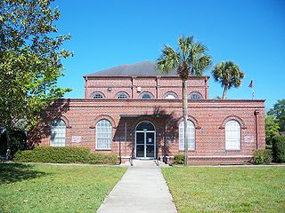
Bell is a town in Gilchrist County, Florida, United States. The population was 456 at the 2010 census, up from 349 in 2000. It is situated in the northern part of the county. The middle/high school is home to approximately 750 students.

Citrus Park is an unincorporated census-designated place in Hillsborough County, Florida, United States. The population was 24,252 at the 2010 census, up from 20,226 at the 2000 census.

Bloomfield Township is a civil township of Huron County in the U.S. state of Michigan. As of the 2000 census, the township population was 535.

Chesterfield Charter Township is a charter township of Macomb County in the U.S. state of Michigan. As of the 2000 census, the township population was 37,405. The 2010 Census places the population at 43,381. The township was organized in 1842, formed out of a portion of Macomb Township. The township is part of Metro Detroit.
Worth Township is a civil township of Sanilac County in the U.S. state of Michigan. The population was 4,021 at the 2000 census.

Fort Gratiot Township is a charter township of St. Clair County in the U.S. state of Michigan. The population was 10,691 at the 2000 census. It is named for Fort Gratiot, an American fort located there off and on between 1814 and 1879.

Chalco is a census-designated place (CDP) in northern Sarpy County, Nebraska, United States, and an adjacent suburb of Omaha, with La Vista, Nebraska to the southeast. The population was 10,994 at the 2010 census.
Anthony is an unincorporated community in Marion County, Florida, United States. It is located on County Road 200A. The community is part of the Ocala Metropolitan Statistical Area. Although it is unincorporated, Anthony has a post office with ZIP code 32617.
Bartlett is an unincorporated community in Isle of Wight County, Virginia, United States. It is located at the junction of U.S. Route 17, U.S. Route 258, and State Route 32, on the James River Bridge approach southeast of Smithfield.
WWOK-LP is a non-commercial LPFM radio station located in Greenville, South Carolina, that features Easy Listening music. The station is licensed by the FCC to broadcast with an ERP of .001 kW.

El Espinar is a municipality in the province of Segovia, Castile and León, Spain. It is located 60 km north-west of Madrid. According to the 2009 census (INE), the municipality has a population of 9,535 inhabitants.
Lottieville is an unincorporated community in Gilchrist County, Florida, United States. It is located on State Road 26, approximately 5 miles (8.0 km) west of Trenton.
Waters Lake is an unincorporated community in Gilchrist County, Florida, United States. It is located about 5 miles (8.0 km) south of Craggs, just east of State Road 47 on a lake of the same name, for which it is named.
Wilcox Junction is an unincorporated community in Gilchrist County, Florida, United States. It is located 1.4 miles (2.3 km) west of Wilcox, and 1.4 miles (2.3 km) northwest of Fanning Springs.
Gulf Hammock is an unincorporated community in Levy County, Florida, United States. It is near the edge of, and named for, the large wetlands area known as Gulf Hammock. It is home to the Waccasassa Fishing Club and is located on US 19-98 and County Road 326, approximately 6 miles (9.7 km) southeast of Otter Creek. The town is the name for the Gulf Hammock Wildlife Management Area.

Lowland Heights is a hamlet in southern Alberta, Canada within the Municipal District of Pincher Creek No. 9. It is located on Highway 6, approximately 83 kilometres (52 mi) southwest of Lethbridge.
Orton is a hamlet in southern Alberta, Canada within the Municipal District of Willow Creek No. 26. It is located 6 kilometres (3.7 mi) south of Highway 3, approximately 31 kilometres (19 mi) west of Lethbridge.
Willow Creek No. 458 is a rural municipality in the Canadian province of Saskatchewan, located in the Census Division 14. The seat of the municipality is located in the Hamlet of Brooksby.

KHWK-FM 99.3 is a radio station serving the Winona, Minnesota area. It airs a country music format from the Westwood One networks.
Bowler is an unincorporated community located in Carbon County, Montana at 45.205°N 108.719°W.