Lake Fenton is a census-designated place (CDP) in Fenton Charter Township, Genesee County in the U.S. state of Michigan. As of the 2010 census the population was 5,559, up from 4,876 at the 2000 census. The CDP includes the unincorporated communities of Bayport Park and Lakeside.

Chesterfield Charter Township is a charter township of Macomb County in the U.S. state of Michigan. As of the 2000 census, the township population was 37,405. The 2010 Census places the population at 43,381. The township was organized in 1842, formed out of a portion of Macomb Township. The township is part of Metro Detroit.

Fort Gratiot Township is a charter township of St. Clair County in the U.S. state of Michigan. The population was 10,691 at the 2000 census. It is named for Fort Gratiot, an American fort located there off and on between 1814 and 1879.

Central Frontenac is a township in eastern Ontario, Canada in the County of Frontenac.
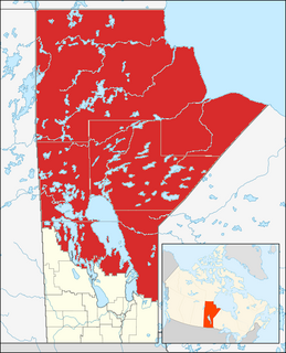
Northern Manitoba is the most northerly region of the Canadian province of Manitoba, added to the province during the last major expansion of its boundaries in 1912. Forestry, mining and hydro-electric development are significant economic drivers with long-term consequences to the environment in the region.

Hamilton East—Stoney Creek is a federal electoral district in Ontario, Canada, that has been represented in the House of Commons of Canada since 2004.

Pine River may refer to any of the following streams in the U.S. state of Michigan:
- Pine River. The main branch forms with the confluence of the East and West Branches of the Pine River at 44°29′38″N83°23′16″W in Alcona County. The South Branch joins approximately 1.5 miles (2.4 km) to the south and flows into Iosco County, where it empties into Van Etten Lake at 44°29′38″N83°23′16″W northwest of Oscoda.
- Pine River. The main branch is formed by the confluence of the North and Middle Branches northeast of Standish and flows into the Saginaw Bay of Lake Huron at 43°58′32″N83°51′16″W. The South Branch Pine River joins the main stream at 43°59′08″N83°53′17″W.
- Pine River is a short waterway, which along with Round Lake, connects Lake Charlevoix with Lake Michigan at Charlevoix.
- Pine River rises in Chippewa County and flows south through Mackinac County into the St. Martin Bay of Lake Huron at 46°03′09″N84°39′22″W The North Pine River, also known as the North Branch Pine River, joins at 46°12′20″N84°36′17″W. Another tributary, Hemlock Creek, is also known as Pine River.
- Pine River, also known as the South Branch Manistee River, rises in southeast Wexford County, flows southwest across northwest Osceola County, then west and north through the northeast corner of Lake County and back into southwest Wexford County, emptying into the Tippy Dam Pond on the Manistee River at 44°13′37″N85°54′27″W. The main stream is formed from the confluence of the East Branch Pine River with the North Branch Pine River at 44°06′02″N85°31′40″W. Another tributary, the Spaulding Creek, is also known as the Little Pine River
- Pine River, in Marquette County, is a very short stream draining Pine Lake into Lake Superior at 46°53′27″N87°52′13″W, north of the Huron Mountains.
- Pine River rises in from Pine Lake in eastern Mecosta County, flows mostly south and east through Isabella County, then south along eastern edge of Montcalm County, then east and north through Gratiot County and Midland County, emptying into the Chippewa River at 43°36′06″N84°17′33″W, just about two miles before it joins the Tittabawassee River near Midland. The South Branch Pine River joins the main stream at 43°30′37″N85°00′02″W Another tributary, Miller Creek, is also sometimes known as Pine River or the West Branch Pine River. The North Branch Pine River joins the main stream at 43°26′03″N84°50′18″W.
- Pine River empties into the St. Clair River at 42°49′13″N82°29′08″W on the south side of St. Clair. The South Branch Pine River joins the main stream at 42°58′11″N82°37′10″W. Another tributary, Quakenbush Drain, is also sometimes known as Pine River.
- Pine Creek empties into Lake Superior and is also known as the Pine River.

Palestine is an unincorporated community in Harrison Township, Kosciusko County, in the U.S. state of Indiana.

Valle de Hecho is a municipality located in the province of Huesca, Aragon, Spain. According to the 2004 census (INE), the municipality has a population of 984 inhabitants.

Govan is a town in the province of Saskatchewan, Canada located 111 kilometres north of Regina on Highway 20. In 2011 the town had 216 residents.
San Pedro de la Cueva is a town in San Pedro de la Cueva Municipality, in the Mexican state of Sonora. It is located in the center of the state at an elevation of 500 meters.
Basement 414 or 'B414' was a venue for various forms of artistic expression located in Lansing, Michigan. The venue hosted a variety of art exhibitions of any medium including paintings, musical acts, video and performance art, and other crafts including things such as napkin art. Artists such as Andrew W.K., Dead Prez and the Peppermint Creek Theatre Company, among others, have performed there.
Joshua is an unincorporated community in DeSoto County, Florida, United States, located approximately 5 miles (8.0 km) east of Arcadia on State Road 70.

Surginer is an unincorporated community in Marengo County, Alabama, United States. Surginer had a post office at one time, but it no longer exists.
Mountain Lake (Ontario) may refer to one of a number of lakes in Ontario, Canada with this precise name or to others with similar names.
Hamilton East—Stoney Creek is a provincial electoral district in Ontario, Canada, that has been represented in the Legislative Assembly of Ontario since the 2007 provincial election.

The Peche Island Rear Range Light was a historic lighthouse "off Peche Island in the entrance to the Detroit River from Lake St. Clair." Located in American waters just north of the border to Canada it was moved to Marine City, Michigan upon its deactivation.

Pleasant Hill is an unincorporated community in Lincoln Parish, Louisiana, United States.

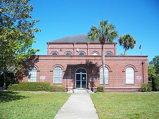
Boyd Hill Nature Preserve is a 245-acre (99 ha) protected area in St. Petersburg, Florida, Pinellas County, Florida. The preserve is located on the shores of Lake Maggiore (Florida) in south St. Petersburg. It is operated by St. Petersburg Parks and Recreation and includes the Boyd Hill Environmental Center, a bird-of-prey aviary, and more than three miles of trails through a variety of ecosystems. Facilities include a playground and picnic areas. The preserve is used for school field trips and hosts environmental education programs. It is located at 1101 Country Club Way South.