Warburton, Greater Manchester

Last updated

Warburton
St Werburghs Church 3quarter.jpg
St Werburgh's Church
Greater Manchester UK location map 2.svg
Red pog.svg
Warburton
Location within Greater Manchester
Population286 (2001 census)
OS grid reference SJ697896
Metropolitan borough
Metropolitan county
Region
Country England
Sovereign state United Kingdom
Post town LYMM
Postcode district WA13
Dialling code 01925
Police Greater Manchester
Fire Greater Manchester
Ambulance North West
UK Parliament
List of places
UK
England
Greater Manchester
53°24′11″N2°27′18″W / 53.403°N 2.455°W / 53.403; -2.455

Warburton is a village and civil parish within the Metropolitan Borough of Trafford in Greater Manchester, England. [1] Historically in Cheshire, Warburton lies on the south bank of the River Mersey between the borough of Warrington and Greater Manchester. In the 21st century, the village remains predominantly rural. Altrincham is the nearest town. According to the 2001 census, the parish had a population of 286. [2]

Contents

Warburton has a history of settlement stretching back to the 11th century, with the possibility of earlier habitation. There are 17 listed buildings in the village, [3] including the timber framed Grade I Church of St Werburgh, which is at least 700 years old. [4] Among the other listed buildings are examples of architect John Douglas' work, including the second Church of St Werburgh, built in 1883. [5] In 2006, Time Team excavated in the lands of Moss Brow Farm in Warburton, looking for a Roman fortlet. However, no evidence of a fortlet was found and the previously identified 'punic' ditch turned out to be the remains of an 18th-century hedgerow. [6]

History

Quernstones found in Warburton Quernstones found in Warburton.JPG
Quernstones found in Warburton

Some limited evidence has been found of activity on the site of Warburton dating from the Bronze Age, through the Iron Age and Roman periods; these include a flint blade, six Mesolithic tools, pieces of quernstone, and a snake bracelet. [7] Archaeological evidence indicates that the area around Warburton has been used agriculturally since at least the Roman times. [8] In the Domesday Book, the name was Warburgtune which name has evolved to today's 'Warburton'. The suffix –ton means a settlement or farmstead in Old English, indicating that the settlement has pre-Conquest origins. It has been suggested that Warburton was the site of an Anglo-Saxon burgh or defended settlement, possibly either called "Toppingburgh" orWeard byrig, established by Aethelflaed, Queen of the Mercians, in 915 during the wars with the Vikings. However, it now seems likely that site lay on the Wales–Cheshire border. [9] [10]

The first documented reference to Warburton occurs in the Domesday Book, where the two manors of Warburton were recorded; the manors were united by the late 12th century. Before the Norman conquest, the area was controlled by the Anglo-Saxon thegn Aelfward. Although the Domesday Book records no church in Warburton, it is possible that the church dedicated to Saint Werburgh is pre-Conquest. The omission of the church may not be significant, as not all pre-Conquest churches or chapels were recorded in the Domesday survey. [7] The first documented evidence of a church in Warburton was in a deed of 1187, when it was a chapel of ease for the parish of Lymm. Warburton became a separate parish in the 13th century. The church is surrounded by a ditch and bank, probably dating to at least the 14th century. Warburton is also the site of a medieval priory, near the Church of St Werburgh; although the priory was only formed in the 13th century, it was dissolved in 1270. [7]

Warburton was predominantly a farming village during the medieval period. The north western corner of the township was used as a deer park. Warburton grew as an agricultural town during the medieval period, and it remained almost untouched by the Industrial Revolution; this is reflected in the population change between 1801 and 1901, dropping from 466 to 403, with little variation at a time when the rest of Trafford was expanding rapidly. [7]

Administration

The civil parish of Warburton was created in 1894, under the Local Government Act 1894 and has its own parish council. [7] [11] Warburton became part of the Metropolitan Borough of Trafford in 1974 upon the borough's creation, but was previously in Bucklow Rural District. The village is part of the Bowdon electoral ward; [12] as of the 2012 local elections the councillors for the Bowdon ward are all Conservative. [13] Warburton lies in the Altrincham and Sale West constituency, which since its formation in 1997 has been represented in the House of Commons by the Conservative MP Sir Graham Brady. [14]

Geography

The village of Lymm lies to the south west of Warburton in the borough of Warrington, with the River Bollin forming the border between the two villages. The Bollin joins the River Mersey in the village; however the Mersey in Warburton has dried up, as it was diverted into the Manchester Ship Canal further upstream. To the east lie Dunham Town, Dunham Massey, Bowdon and Altrincham, with Little Bollington to the south, and Partington and Urmston to the north. The local geology is lower keuper marl, with a ridge of sand and gravel running from Warburton to Dunham. [7]

Transport

The main roads running through Warburton are the A6144 and B5159. A local bus service, 5 (operated by Warrington Borough Transport) links Warburton with Warrington and Altrincham. Formerly, the 38 (operated by Warrington Coachways) also used to serve the village.

Demography

At the 2001 UK census, Warburton had a total population of 286. For every 100 females, there were 121.7 males. The average household size was 2.44. [2] Of those aged 16–74 in Warburton, 43.2% had no academic qualifications or one GCSE, similar to the figures for all of Trafford (40.8%) and in England (45.5%). [15] According to the census, 1.40% were unemployed and 33.49% were economically inactive. [16] 16.43% of the population were under the age of 16 and 6.64% were aged 75 and over; the mean age of the people of Warburton was 43.03. 69.34% of residents described their health as 'good'. [17]

Population change

Population growth in Warburton since 1801
Year180118111821183118411851186118711881189119011911192119311951196119712001
Population466470509510509489484452426416403403379354376328289286
Source: [18]

Landmarks

Churches

Warburton has two churches of note. St Werburgh's (grid reference SJ696895 ) is a timber framed church and a Grade I Listed Building, one of six in Trafford. [19] Of the 29 timber-framed churches that survive in England and Wales, St Werbugh's is one of the oldest. The church dates to at least the 14th century, [4] and may be built on the site of an earlier Saxon chapel. It is rarely used for worship but is accessible to visitors. [9] The church features an early-17th-century font, a Jacobean pulpit, and a 1645 altar. [4] Nearby are the remains of the old village cross, complete with stocks whose wooden restraints are modern, though the supporting pillars are much older. [9] The other church in Warburton, also dedicated to St Werburgh, was built in 1883 by John Douglas and is a Grade II Listed Building. The church is made of red sandstone with a clay tile roof. [5]

Grade II listed buildings

The new St Werburgh's Church is a Grade II listed building Warburton New 4.jpg
The new St Werburgh's Church is a Grade II listed building

As well as the two churches dedicated to Saint Werburgh, there are 15 other Grade II listed buildings. The parish rooms and caretaker's house were built in 1889, and designed by John Douglas. [20] Also built in the village by Douglas was the post office in 1893, [21] and Warburton School in 1871–72; this has been converted to a residence but still features crucks supporting the roof. [22] Some farm buildings in Warburton are also listed, including the farmhouse on Moss Lane. The barn is 18th-century but features crucks which may be 17th-century or earlier. [23] The timber framed farm building on Park Road is 17th-century in origin; [24] the late-18th-century farmhouse on Warburton Lane was made with Flemish bond brick and has a slate roof. [25] The barn on Paddock Lane dates from the 17th century. [26] Also on Paddock Lane are two farmhouses: one was built in 1717 by Thomas Egerton and features an inglenook fireplace; [27] the other is Wigsey Farmhouse which was originally built in the 17th century with later additions, including a 19th-century porch. [28] The building on Warburton Lane near Villa Farmhouse was originally a timber-framed building from the 16th or early 17th century. The house features late-16th- or early-17th-century frescos of a woman, possibly St Werburgh, with two geese and a rose. [29]

There is the base of a stone cross on Townfield Lane, [30] and wooden stocks nearby, probably dating from the 17th century. [31] One of the more unusual listed structures in Warburton is the 25 m stretch of wall constructed from flagstones, probably built in the 18th or 19th century. [32] There are two listed structures in the grounds of the old Church of St Werburgh: a lychgate from the late 19th century, and a sundial from 1765. [33] [34]

Warburton Toll Bridge

The toll booth Toll Booth - geograph.org.uk - 27250.jpg
The toll booth
Rixton and Warburton Bridge Act 1863
Act of Parliament
Royal Coat of Arms of the United Kingdom (variant 1, 1952-2022).svg
Long title An Act for the making and maintaining of a Bridge over the River Mersey, to be called "Rixton and Warburton Bridge," with Roads thereto; and for other Purposes.
Citation c. lxiii
Dates
Royal assent 8 June 1863
Text of statute as originally enacted
Rixton and Warburton Bridge Amendment Act 1867
Act of Parliament
Royal Coat of Arms of the United Kingdom (variant 1, 1952-2022).svg
Long title An Act to enable the Rixton and Warburton Bridge Company to raise further Money, and to create Preference Shares; and for other Purposes.
Citation 30 & 31 Vict. c. xxxvii
Dates
Royal assent 31 May 1867
Text of statute as originally enacted

Warburton Toll Bridge and Warburton Bridge Road form a privately-owned statutory tolled undertaking carrying a public highway upon which tolls are payable. [35] The high-level cantilever bridge crosses the Manchester Ship Canal on the B5159 road, connecting the A57 with the A6144, and was commissioned under the Rixton and Warburton Bridge Act 1863 (c. lxiii). [36] The original stone bridge spanned the River Mersey prior to its later diversion into the Manchester Ship Canal, over which a new bridge was built. Section 29 of the Rixton and Warburton Bridge Act 1863 established that if the Mersey and Irwell Navigation was upgraded to allow sea-going vessels, then the Rixton and Warburton Bridge Company would be responsible for all costs, including its ongoing maintenance. [37]

Both bridges and the unadopted approach roads are privately maintained. [38] It is one of the few remaining pre-motorway toll bridges in the United Kingdom, [10] and the only one in Greater Manchester. [39]

It is sometimes incorrectly claimed that the tolls are payable for crossing the now-defunct original River Mersey bridge, [40] but section 48 of the Rixton and Warburton Bridge Act 1863 makes the toll payable for "passing over, along or upon the Bridge and Roads, or any of them, or any part thereof..." [36] Section 9 of the Manchester Ship Canal (Various Powers) Act 1890 (53 & 54 Vict. c. ccxxvii) [41] included the diversion of the original road and the new Ship Canal bridge within the scope of the toll charges.

The level of tolls was originally fixed, but can now be changed under the provisions of the Transport Charges &c. (Miscellaneous Provisions) Act 1954 (2 & 3 Eliz. 2. c. 64).

Time Team in Warburton

Since 1998, archaeological techniques such as field walking have led to the discovery of finds ranging in age from prehistoric flints and Bronze Age axe heads to Roman and late medieval finds. Featuring prominently amongst these finds were Roman artefacts including coins, brooches and a snake bracelet. [42] At the invitation of local historian Jim Balme, Time Team excavated in Warburton in September 2006. They were searching for a Roman fortlet that previous archaeological digs by South Trafford Archaeological Group (STAG) indicated might be present. Though no evidence of a Roman fortlet was found, the discovery of strip lynchets indicates that there was a Romano-British farm in Warburton. [8] [43] The presence of Roman finds was explained as rubbish, mixed in with manure to be spread on the crops.

See also

Related Research Articles

<span class="mw-page-title-main">Tameside</span> Borough in Greater Manchester, England

Tameside is a metropolitan borough of Greater Manchester, England, named after the River Tame, which flows through it, and includes the towns of Ashton-under-Lyne, Audenshaw, Denton, Droylsden, Dukinfield, Hyde, Mossley and Stalybridge. Tameside is bordered by the metropolitan boroughs of Stockport to the south, Oldham to the north and northeast, Manchester to the west, and to the east by the Borough of High Peak in Derbyshire. As of 2021, the population of Tameside was 231,199, making it the 8th-most populous borough of Greater Manchester by population.

<span class="mw-page-title-main">Altrincham</span> Town in Greater Manchester, England

Altrincham is a market town in Trafford, Greater Manchester, England, south of the River Mersey. It is 8 miles (13 km) southwest of Manchester, 3 miles (5 km) southwest of Sale and 10 miles (16 km) east of Warrington. At the 2011 census, it had a population of 52,419.

<span class="mw-page-title-main">Trafford</span> Borough in Greater Manchester, England

Trafford is a metropolitan borough of Greater Manchester, England, with an estimated population of 235,546 in 2021. It covers 106 square kilometres (41 sq mi) and includes the area of Old Trafford and the towns of Altrincham, Stretford, Urmston, Partington and Sale. The borough was formed in 1974 as a merger of six former districts and part of a seventh. The River Mersey flows through the borough, separating North Trafford from South Trafford, and the historic counties of Lancashire and Cheshire. Trafford is the seventh-most populous district in Greater Manchester.

<span class="mw-page-title-main">Sale, Greater Manchester</span> Town in Greater Manchester, England

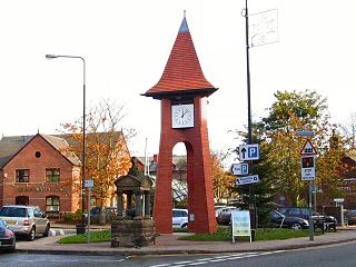
Sale is a town in Trafford, Greater Manchester, England, in the historic county of Cheshire on the south bank of the River Mersey, 2 miles (3.2 km) south of Stretford, 3 miles (4.8 km) northeast of Altrincham, and 5 miles (8.0 km) southwest of Manchester. In 2021, it had a population of 54,515.

<span class="mw-page-title-main">Timperley</span> Human settlement in England

Timperley is a suburban area in the borough of Trafford, Greater Manchester, England. Within the boundaries of the historic county of Cheshire, it is approximately six miles southwest of central Manchester. The population at the 2011 census was 11,061.

<span class="mw-page-title-main">Hale, Greater Manchester</span> Human settlement in England

Hale is a suburb and electoral ward within the Metropolitan Borough of Trafford, in Greater Manchester, England. The population of the village taken at the 2011 census was 15,315. It is contiguous with the southeast of Altrincham, about 9 mi (14 km) southwest of the city of Manchester.

<span class="mw-page-title-main">Stretford</span> Town in Greater Manchester, England

Stretford is a market town in Trafford, Greater Manchester, England. It is situated on flat ground between the River Mersey and the Manchester Ship Canal, 4 miles (6.4 km) south of Manchester, 3 miles (4.8 km) south of Salford and 4 miles (6.4 km) north-east of Altrincham. Stretford borders Chorlton-cum-Hardy to the east, Moss Side and Whalley Range to the south-east, Hulme to the north-east, Urmston to the west, Salford to the north, and Sale to the south. The Bridgewater Canal bisects the town.

<span class="mw-page-title-main">Urmston</span> Town in Greater Manchester, England

Urmston is a town in Trafford, Greater Manchester, England, which had a population of 41,825 at the 2011 Census. Historically in Lancashire, it is 5 miles (8 km) southwest of Manchester city centre. The southern boundary is the River Mersey, with Stretford lying to the east and Flixton to the west. Davyhulme lies to the north of the town centre. Urmston covers an area of 4,799 acres (19.42 km2).

<span class="mw-page-title-main">Partington</span> Human settlement in England

Partington is a town and civil parish in the Metropolitan Borough of Trafford, Greater Manchester, England, ten miles (16 km) south-west of Manchester city centre. Within the boundaries of the historic county of Cheshire, it lies on the southern bank of the Manchester Ship Canal, opposite Cadishead on the northern bank. It has a population of 7,327.

<span class="mw-page-title-main">Dunham Massey</span> English civil parish

Dunham Massey is a civil parish in the Metropolitan Borough of Trafford, Greater Manchester, England. The parish includes the villages of Sinderland Green, Dunham Woodhouses and Dunham Town, along with Dunham Massey Hall and Park, formerly the home of the last Earl of Stamford and owned by the National Trust since 1976. Dunham Massey is in the historic county of Cheshire, but since 1974 has been part of Trafford Metropolitan Borough; the nearest town is Altrincham. At the 2001 census, the parish had a population of 475.

<span class="mw-page-title-main">Bowdon, Greater Manchester</span> Suburb in Trafford, England

Bowdon is a suburb of Altrincham and electoral ward in the Metropolitan Borough of Trafford, Greater Manchester, England.

<span class="mw-page-title-main">Flixton, Greater Manchester</span> Suburb in Greater Manchester, England

Flixton is a suburb and electoral ward in the Metropolitan Borough of Trafford, Greater Manchester, England. The population of the ward at the 2011 census was 10,786. It lies six miles (9.7 km) southwest of Manchester city centre, in the historic county of Lancashire.

<span class="mw-page-title-main">St Werburgh's Church, Warburton</span> Church in Greater Manchester, England

St Werburgh's Church is the name of two separate churches in the village of Warburton, Greater Manchester, England. The older church is located to the west of the village, and may date back as far as the middle of the 13th century. It is now a redundant church but services are held in the summer months. The church is recorded in the National Heritage List for England as a designated Grade I listed building. The authors of the Buildings of England series call this church "a lovable muddle".

<span class="mw-page-title-main">Scheduled monuments in Greater Manchester</span>

There are 37 scheduled monuments in Greater Manchester, a metropolitan county in North West England. In the United Kingdom, a scheduled monument is a "nationally important" archaeological site or historic building that has been given protection against unauthorised change by being placed on a list by the Secretary of State for Digital Culture, Media and Sport; Historic England recommends sites for scheduling to the Secretary of State. Scheduled monuments are defined in the Ancient Monuments and Archaeological Areas Act 1979 and the National Heritage Act 1983. There are nearly 20,000 entries on the schedule, which is maintained by Historic England as part of the National Heritage List for England; more than one site can be included in a single entry. While a scheduled monument can also be recognised as a listed building, Historic England's aim is to set the most appropriate form of protection in place for the building or site. Applications to deschedule a site are administered Historic England, who will carry out an assessment and make a recommendation to the Secretary of State.

<span class="mw-page-title-main">Midhopestones</span> Village in South Yorkshire, England

Midhopestones is a village in the civil parish of Bradfield within the Stocksbridge and Upper Don electoral ward in the borough of the City of Sheffield, England.

Church House is adjacent to St Werburgh's Church, in Bent Lane in the village of Warburton, Greater Manchester, England. It is recorded in the National Heritage List for England as a designated Grade II listed building.

<span class="mw-page-title-main">Grade I listed buildings in Greater Manchester</span>

There are 48 Grade I listed buildings in Greater Manchester, England. In the United Kingdom, the term listed building refers to a building or other structure officially designated as being of special architectural, historical or cultural significance; Grade I structures are those considered to be "buildings of exceptional interest". In England, the authority for listing under the Planning Act 1990 rests with Historic England, a non-departmental public body sponsored by the Department for Culture, Media and Sport.

Warburton is a civil parish in the Metropolitan Borough of Trafford, Greater Manchester, England. It contains 22 listed buildings that are recorded in the National Heritage List for England. Of these, one is listed at Grade I, the highest of the three grades, and the others are at Grade II, the lowest grade. The parish contains the village of Warburton, and is otherwise rural. Most of the listed buildings are houses, farmhouses and farm buildings. The other listed buildings include churches and associated structures, a war memorial, and an enclosure containing stocks and a cross base, with its wall also listed.

Bowdon is a village in the Metropolitan Borough of Trafford, Greater Manchester, England. It contains 33 listed buildings that are recorded in the National Heritage List for England. Of these, two are listed at Grade II*, the middle grade, and the others are at Grade II, the lowest grade. Bowdon originated as a village in a rural environment, and grew during the 19th century as a commuter town for Manchester, attracting wealthy merchants who built substantial houses. The oldest listed buildings are farmhouses and farm buildings, and houses and cottages clustered around the church, and the later ones include some of the larger houses. The other listed buildings include the church and associated structures, a public house, a drinking fountain, and a war memorial.

References

Notes

  1. "Greater Manchester Gazetteer". Greater Manchester County Record Office. Place Names T to W. Archived from the original on 18 July 2011. Retrieved 12 May 2010.
  2. 1 2 "Warburton civil parish Neighbourhood Statistics". Office for National Statistics. Archived from the original on 16 March 2009. Retrieved 31 August 2007.
  3. "Listed Buildings in Warburton". Images of England. English Heritage. Archived from the original on 13 July 2007. Retrieved 11 September 2007.
  4. 1 2 3 Nevell & Hradil 2005 , pp. 87–88
  5. 1 2 Historic England. "St Werburgh's Church, 1883 (1347816)". National Heritage List for England . Retrieved 3 September 2007.
  6. "Moss Brow Farm, Warburton, Greater Manchester: Archaeological Evaluation and Assessment of the Results" (PDF). Wessex Archaeology. March 2007. Retrieved 7 May 2015.
  7. 1 2 3 4 5 6 Nevell 1997 , pp. 3, 5, 9, 12, 20, 24–25, 27, 29–32, 43, 68, 95
  8. 1 2 "What they found". Time Team. Channel 4. 1 January 2007. Archived from the original on 5 September 2008. Retrieved 21 May 2007.
  9. 1 2 3 Nevell 2003 , pp. 1–6
  10. 1 2 Warburton 1970 , p. 1
  11. "Warburton Parish Council". Trafford Council. Retrieved 12 May 2010.
  12. "Grants to improve tourist accommodation offer in Bowdon". Trafford Council. 5 August 2011. Retrieved 19 January 2011.
  13. "Bowdon – Councillors in this Ward". Trafford Council. Archived from the original on 8 March 2012. Retrieved 8 May 2012.
  14. "Altrincham and Sale West". guardian.co.uk. London: Guardian News and Media. Archived from the original on 16 March 2009. Retrieved 2 February 2012.
  15. "Trafford Metropolitan Borough key statistics". Office for National Statistics. Archived from the original on 26 December 2007. Retrieved 13 December 2007.
  16. "Warburton civil parish work and qualifications". Office for National Statistics. Retrieved 31 August 2007.
  17. "Warburton civil parish census data". Office for National Statistics. Retrieved 31 August 2007.
  18. A Vision of Britain through Time Archived 16 October 2012 at the Wayback Machine
  19. "Planning and building control: listed buildings". Trafford Council. Archived from the original (PDF) on 16 July 2011. Retrieved 14 December 2007.
  20. Historic England (22 August 2002). "Church House (1067897)". National Heritage List for England . Retrieved 3 September 2007.
  21. Historic England (22 August 2002). "Post Office House (1101758)". National Heritage List for England . Retrieved 3 September 2007.
  22. Historic England (22 August 2002). "The School, Dunham Road (1356531)". National Heritage List for England . Retrieved 3 September 2007.
  23. Historic England (21 August 2002). "Moss Lane Farmhouse (1101723)". National Heritage List for England . Retrieved 3 September 2007.
  24. Historic England (22 August 2002). "Warburton Park Farmyard (1356532)". National Heritage List for England . Retrieved 3 September 2007.
  25. Historic England (1 September 2002). "Heathlands Farmhouse, Warburton Lane (1346578)". National Heritage List for England . Retrieved 3 September 2007.
  26. Historic England (1 September 2002). "Overtown Farmhouse barn, Paddock Lane (1067899)". National Heritage List for England . Retrieved 3 September 2007.
  27. Historic England (30 December 2000). "Paddocklane Farmhouse, Paddock Lane (1347811)". National Heritage List for England . Retrieved 3 September 2007.
  28. Historic England (15 September 2002). "Wigsey Farmhouse (1083579)". National Heritage List for England . Retrieved 3 September 2007.
  29. Historic England (21 August 2002). "Warburton Lane (1338885)". National Heritage List for England . Retrieved 3 September 2007.
  30. Historic England (30 June 2001). "Cross Base, Wigsey Lane (1346576)". National Heritage List for England . Retrieved 3 September 2007.
  31. Historic England (30 December 2000). "Stocks, Wigsey Lane (1067901)". National Heritage List for England . Retrieved 3 September 2007.
  32. Historic England (30 December 2000). "Stone flag wall (1356493)". National Heritage List for England . Retrieved 3 September 2007.
  33. Historic England (30 December 2000). "Lychgate, Old Church of Saint Werberg (1083592)". National Heritage List for England . Retrieved 3 September 2007.
  34. Historic England (30 December 2000). "Sundial, Old Church of Saint Werberg (1083561)". National Heritage List for England . Retrieved 3 September 2007.
  35. "Warburton Toll Bridge". www.warburtontollbridge.co.uk.
  36. 1 2 Rixton and Warburton Bridge Act 1863 (c. lxiii) "An Act for the making and maintaining of a Bridge over the River Mersey, to be called "Rixton and Warburton Bridge," with Roads thereto; and for other Purposes." (8 June 1863)
  37. Rixton and Warburton Bridge Act 1863 s. 29 (PDF), Provided also, that the Expense of working, managing, repairing, and uplifting the Said Swivel or other opening Bridge [over the Ship Canal] shall be borne and paid by the Company hereby incorporated [The Rixton and Warburton Bridge Company] or, as the Case may be, shall be refunded by them to the said Company of Proprietors [of the Mersey and Irwell Navigation].
  38. "Statutory Tolled Undertakings in the UK". Department for Transport. Retrieved 7 November 2008.
  39. Nicholls 2004 , p. 90
  40. "Warburton Toll Bridge investment plan sparks calls for Public Inquiry". Warrington Worldwide. 21 July 2021.
  41. "RWB/B4 - Manchester Ship Canal (Various Powers) Act 1890" (PDF). Warburton Toll Bridge. May 2022. Retrieved 4 July 2022.
  42. "Cameo corner: Making the silver snake's head bracelet". Time Team. Channel 4. 4 March 2007. Archived from the original on 7 October 2008. Retrieved 21 May 2007.
  43. Brennand 2006 , p. 77

Bibliography