Ward Hunt Ice Shelf

Last updated

Ward Hunt Island, Ward Hunt Ice Shelf and Cape Columbia, Ellesmere Island, Canada. View towards east. Ward Hunt Island, Ice Shelf 06.jpg
Ward Hunt Island, Ward Hunt Ice Shelf and Cape Columbia, Ellesmere Island, Canada. View towards east.
Ward Hunt Ice Shelf, north of Ellesmere Island, Canada. View from Ward Hunt Ice Rise towards west, July 1988. Ward Hunt Island, Ice Shelf 05.jpg
Ward Hunt Ice Shelf, north of Ellesmere Island, Canada. View from Ward Hunt Ice Rise towards west, July 1988.

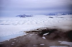
The Ward Hunt Ice Shelf is the largest ice shelf in the Arctic, located near Ward Hunt Island, on the north coast of Ellesmere Island, Nunavut, Canada. During the 20th century the Ellesmere Ice Shelf broke up into six separate shelves, the largest being Ward Hunt. Ward Hunt Ice Shelf is currently about 155 square miles (400 km2) in size, and has been in place for approximately 4,000 years [1] as part of a continuous ice shelf that encompassed the northern coast of Ellesmere Island until the beginning of the twentieth century. [2] In 2005 one of the other shelves, the 25-square-mile (65 km2) Ayles Ice Shelf, calved completely. [2]

The Ellesmere ice shelf was documented by the British Arctic Expedition of 1875–76, in which Lieutenant Pelham Aldrich's party went from Cape Sheridan (82.47°N, 61.50°W) west to Cape Alert (82.27°N, 85.55°W), including the Ward Hunt Ice Shelf. [3] Reports from Robert Peary's expedition in 1906 described a “broad glacial fringe” covering much of the coast of northwestern Ellesmere Island. [4]

The Ward Hunt ice sheet began breaking up approximately 100 years ago, but was believed to have stabilized by the early 1980s. However, in April 2000, satellite images revealed that a large crack in the ice had begun to form, and in 2003, it was announced that the ice sheet had split completely in two in 2002, releasing a huge pool of fresh water from the largest epishelf lake in the Northern Hemisphere, located in Disraeli Fjord. [5] In April 2008, it was discovered that the shelf was fractured into dozens of deep, multi-faceted cracks. [6] In late July 2008, it was announced that nearly 8 square miles (21 km2) broke away from the shelf. [2] In August 2010, another 50 km² (19 sq mi) calved off from the northeast quarter of the ice shelf. [7]

The icebergs released by the breakup now pose a potential danger to shipping and offshore development in the region. Loss of microbial ecosystems caused by the release of the freshwater may also have far-ranging ecological impacts. [8]

The breakup of the Ward Hunt Ice Shelf is tied to steady and dramatic increases in the average temperature of the region over the past decades, correlated with global warming. [9] [10]

Al Gore mentions the Ward Hunt Ice Shelf in his 2007 documentary An Inconvenient Truth .

Related Research Articles

<span class="mw-page-title-main">North Pole</span> Northern point where the Earths axis of rotation intersects its surface

The North Pole, also known as the Geographic North Pole or Terrestrial North Pole, is the point in the Northern Hemisphere where the Earth's axis of rotation meets its surface. It is called the True North Pole to distinguish from the Magnetic North Pole.

<span class="mw-page-title-main">Ellesmere Island</span> Island of the Arctic Archipelago in Nunavut, Canada

Ellesmere Island is Canada's northernmost and third largest island, and the tenth largest in the world. It comprises an area of 196,236 km2 (75,767 sq mi), slightly smaller than Great Britain, and the total length of the island is 830 km (520 mi).

<span class="mw-page-title-main">Iceberg</span> Large piece of freshwater ice broken off a glacier or ice shelf and floating in open water

An iceberg is a piece of freshwater ice more than 15 m long that has broken off a glacier or an ice shelf and is floating freely in open (salt) water. Smaller chunks of floating glacially-derived ice are called "growlers" or "bergy bits". The 1912 loss of the RMS Titanic led to the formation of the International Ice Patrol in 1914. Much of an iceberg is below the surface, which led to the expression "tip of the iceberg" to illustrate a small part of a larger unseen issue. Icebergs are considered a serious maritime hazard.

<span class="mw-page-title-main">Ross Ice Shelf</span> Ice shelf in Antarctica

The Ross Ice Shelf is the largest ice shelf of Antarctica. It is several hundred metres thick. The nearly vertical ice front to the open sea is more than 600 kilometres (370 mi) long, and between 15 and 50 metres high above the water surface. Ninety percent of the floating ice, however, is below the water surface.

<span class="mw-page-title-main">Ice shelf</span> Large floating platform of ice caused by glacier flowing onto ocean surface

An ice shelf is a large floating platform of ice that forms where a glacier or ice sheet flows down to a coastline and onto the ocean surface. Ice shelves are only found in Antarctica, Greenland, Northern Canada, and the Russian Arctic. The boundary between the floating ice shelf and the anchor ice that feeds it is the grounding line. The thickness of ice shelves can range from about 100 m (330 ft) to 1,000 m (3,300 ft).

<span class="mw-page-title-main">Quttinirpaaq National Park</span> National park in Nunavut, Canada

Quttinirpaaq National Park is located on the northeastern corner of Ellesmere Island in the Qikiqtaaluk Region of Nunavut, Canada. It is the second most northerly park on Earth after Northeast Greenland National Park. In Inuktitut, Quttinirpaaq means "top of the world". It was established as Ellesmere Island National Park Reserve in 1988, and the name was changed to Quttinirpaaq in 1999, when Nunavut was created, and became a national park in 2000. The reserve covers 37,775 km2 (14,585 sq mi), making it the second largest park in Canada, after Wood Buffalo National Park.

<span class="mw-page-title-main">Filchner–Ronne Ice Shelf</span> Ice shelf in Antarctica

The Filchner-Ronne Ice Shelf, also known as Ronne-Filchner Ice Shelf, is an Antarctic ice shelf bordering the Weddell Sea.

<span class="mw-page-title-main">Larsen Ice Shelf</span> Ice shelf in Antarctica

The Larsen Ice Shelf is a long ice shelf in the northwest part of the Weddell Sea, extending along the east coast of the Antarctic Peninsula from Cape Longing to Smith Peninsula. It is named after Captain Carl Anton Larsen, the master of the Norwegian whaling vessel Jason, who sailed along the ice front as far as 68°10' South during December 1893. In finer detail, the Larsen Ice Shelf is a series of shelves that occupy distinct embayments along the coast. From north to south, the segments are called Larsen A, Larsen B, and Larsen C by researchers who work in the area. Further south, Larsen D and the much smaller Larsen E, F and G are also named.

Mount Ayles is a mountain located on Ellesmere Island, Nunavut, Canada. It forms part of the border of the Quttinirpaaq National Park. Like the nearby Ayles Ice Shelf, the mountain was named by the Geological Survey of Canada in 1965 for Adam Ayles, a petty officer on-board HMS Alert, who was serving in the British Arctic Expedition under George Nares.

<span class="mw-page-title-main">Arctic Cordillera</span> Terrestrial ecozone in northern Canada

The Arctic Cordillera is a terrestrial ecozone in northern Canada characterized by a vast, deeply dissected chain of mountain ranges extending along the northeastern flank of the Canadian Arctic Archipelago from Ellesmere Island to the northeasternmost part of the Labrador Peninsula in northern Labrador and northern Quebec, Canada. It spans most of the eastern coast of Nunavut with high glaciated peaks rising through ice fields and some of Canada's largest ice caps, including the Penny Ice Cap on Baffin Island. It is bounded to the east by Baffin Bay, Davis Strait and the Labrador Sea while its northern portion is bounded by the Arctic Ocean.

<span class="mw-page-title-main">Ayles Ice Shelf</span>

The Ayles Ice Shelf was one of six major ice shelves in Canada, all on the north coast of Ellesmere Island, Nunavut. The ice shelf broke off from the coast on August 13, 2005, forming a giant ice island 37 m (121 ft) thick and measuring around 14 by 5 km in size. The oldest ice in the ice shelf is believed to be over 3,000 years old. The ice shelf was at, approximately 800 km (500 mi) south of the North Pole.

<span class="mw-page-title-main">British Arctic Expedition</span>

The British Arctic Expedition of 1875–1876, led by Sir George Strong Nares, was sent by the British Admiralty to attempt to reach the North Pole via Smith Sound.

<span class="mw-page-title-main">Ward Hunt Island</span> Island in Nunavut, Canada

Ward Hunt Island is a small, uninhabited island in the Arctic Ocean, located off the north coast of Ellesmere Island near the Ward Hunt Ice Shelf. The island is located just 750 km (470 mi) from the geographical North Pole. The northern cape of Ward Hunt Island is one of the northernmost elements of land in Canada. Only a 17 km (11 mi) stretch of northern coast of Ellesmere Island around Cape Columbia is more northerly. The island is 5.0 km (3.1 mi) long, east to west, and 3.0 km (1.9 mi) wide. The first known sighting was in 1876 by Pelham Aldrich, a lieutenant with the George Nares expedition, and named for George Ward Hunt, who was First Lord of the Admiralty at the time (1874–1877). Today, the Island is part of the Quttinirpaaq National Park.

The Ellesmere Ice Shelf was the largest ice shelf in the Arctic, encompassing about 9,100 square kilometres of the north coast of Ellesmere Island, Nunavut, Canada. The ice shelf was first documented by the British Arctic Expedition of 1875–76, in which Lieutenant Pelham Aldrich's party went from Cape Sheridan to Cape Alert. The continuous mass of the Ellesmere Ice Shelf had been in place for at least 3,000 years.

The uninhabited Marvin Islands are located in the Arctic Ocean across the mouth of Disraeli Fiord, in northern Ellesmere Island within the Quttinirpaaq National Park. Ward Hunt Island lies to the northwest. The island group is a part of the Qikiqtaaluk Region, Nunavut, Canada.

The Markham Ice Shelf was one of five major ice shelves in Canada, all on the north coast of Ellesmere Island, Nunavut. The ice shelf broke off from the coast in early August 2008, becoming adrift in the Arctic Ocean. The 4,500-year-old ice shelf was then 19 square miles (49 km2) in size, nearly the size of Manhattan, and approximately ten stories tall. On September 3, 2008, CNN quoted Derek Mueller, of Trent University in Ontario, Canada as saying to the Associated Press:

"The Markham Ice Shelf was a big surprise because it suddenly disappeared. We went under cloud for a bit during our research and when the weather cleared up, all of a sudden there was no more ice shelf. It was a shocking event that underscores the rapidity of changes taking place in the Arctic... The Markham Ice Shelf had half the biomass for the entire Canadian Arctic Ice Shelf ecosystem as a habitat for cold tolerant microbial life; algae that sit on top of the ice shelf and photosynthesize like plants would. Now that it's disappeared, we're looking at ecosystems on the verge of extinction.

HMS <i>Alert</i> (1856) 19th-century British Royal Navy sloop

HMS Alert was a 17-gun wooden screw sloop of the Cruizer class of the Royal Navy, launched in 1856 and broken up in 1894. She was the eleventh ship of the Royal Navy to bear the name, and was noted for her Arctic exploration work; in 1876 she reached a record latitude of 82° North. Alert briefly served with the US Navy, and ended her career with the Canadian Marine Service as a lighthouse tender and buoy ship.

<span class="mw-page-title-main">Ice calving</span> Breaking of ice chunks from the edge of a glacier

Ice calving, also known as glacier calving or iceberg calving, is the breaking of ice chunks from the edge of a glacier. It is a form of ice ablation or ice disruption. It is the sudden release and breaking away of a mass of ice from a glacier, iceberg, ice front, ice shelf, or crevasse. The ice that breaks away can be classified as an iceberg, but may also be a growler, bergy bit, or a crevasse wall breakaway.

<span class="mw-page-title-main">Petermann Glacier</span>

Petermann Glacier is a large glacier located in North-West Greenland to the east of Nares Strait. It connects the Greenland ice sheet to the Arctic Ocean at 81°10' north latitude, near Hans Island.

<span class="mw-page-title-main">Alfred Ernest Ice Shelf</span>

The Alfred Ernest Ice Shelf is an ice shelf on the north-west part of Ellesmere Island, Canada. This ice mass is one of four remaining ice shelves on the island.

References

  1. Antoniades, D.; Francus, P.; Pienitz, R.; St-Onge, G.; Vincent, W. F. (November 22, 2011). "Holocene dynamics of the Arctic's largest ice shelf". Proceedings of the National Academy of Sciences. 108 (47): 18899–18904. doi: 10.1073/pnas.1106378108 . ISSN   0027-8424. PMC   3223438 . PMID   22025693.
  2. 1 2 3 David Ljunggren (July 29, 2008). "Giant chunks break off Canadian ice shelf". Reuters. Retrieved July 29, 2008.
  3. Jeffries, Martin O. Ice Island Calvings and Ice Shelf Changes, Milne Ice Shelf and Ayles Ice Shelf, Ellesmere Island, N.W.T.. Arctic 39 (1) (March 1986)
  4. Peary, Robert E. (1907). Nearest the Pole; a narrative of the Polar expedition of the Peary Arctic club in the S.S. Roosevelt, 1905–1906, by R.E. Peary, U.S.N. With ninety-five photographs by the author, two maps and a frontispiece in colour by Albert Operti. New York: Doubleday, Page & Co. doi:10.5962/bhl.title.6868.
  5. Michon Scott (January 20, 2004). "Breakup of the Ward Hunt Ice Shelf". Earth Observatory, NASA Goddard Space Flight Center. Retrieved December 30, 2011.
  6. Bob Weber, The Canadian Press (April 12, 2008). "Cracks in Arctic ice shelf signal its demise". The Star. Toronto. Retrieved May 27, 2010.
  7. NASA Visible Earth (August 18, 2010). "Break-up on the Ward Hunt Ice Shelf". Archived from the original on February 10, 2015. Retrieved February 9, 2015.
  8. The Associated Press (September 30, 2011). "Canadian Arctic Nearly Loses Entire Ice Shelf". The Weather Channel. Retrieved September 30, 2011.
  9. "Arctic ice shelf splits". BBC News. September 23, 2003. Retrieved December 30, 2011.
  10. "Global Warming Puts the Arctic on Thin Ice". Natural Resources Defense Council. Retrieved December 30, 2011.

Coordinates: 83°02′25″N73°15′38″W / 83.0403°N 73.2605°W / 83.0403; -73.2605