Missoula County is located in the State of Montana. As of the 2010 United States Census, the population was 109,426, making it Montana's second-most populous county. Its county seat and largest city is Missoula. The county was founded in 1860.

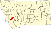
Deer Lodge County is a county in the U.S. state of Montana. As of the 2010 United States Census, the population was 9,298. It forms a consolidated city-county government with its county seat of Anaconda. The county was established in 1865.

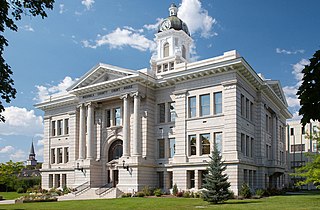
Deer Lodge is an incorporated city in, and the county seat of, Powell County, Montana, United States. The population was 3,111 at the 2010 census. The city is perhaps best known as the home of the Montana State Prison, a major local employer. The Montana State Hospital in Warm Springs, and former state tuberculosis sanitarium in nearby Galen are the result of the power the western part of the state held over Montana at statehood due to the copper and mineral wealth in that area. Deer Lodge was also once an important railroad town, serving as a division headquarters for the Chicago, Milwaukee, St. Paul and Pacific Railroad before the railroad's local abandonment in 1980.

Deer Park is a city in the U.S. state of Texas within the Houston–Sugar Land–Baytown metropolitan area. The city is located in Harris County and is situated in Southeast Texas. At the 2010 U.S. census, the population of Deer Park was 32,010. Deer Park's population grew to 33,474 in 2019 according to the American Community Survey.
The Montana Department of Corrections is a state agency of Montana that operates state prisons and manages community-corrections programs. The agency has its headquarters in Helena.

The Clark Fork, or the Clark Fork of the Columbia River, is a river in the U.S. states of Montana and Idaho, approximately 310 miles (500 km) long. The largest river by volume in Montana, it drains an extensive region of the Rocky Mountains in western Montana and northern Idaho in the watershed of the Columbia River. The river flows northwest through a long valley at the base of the Cabinet Mountains and empties into Lake Pend Oreille in the Idaho Panhandle. The Pend Oreille River in Idaho, Washington, and British Columbia, Canada which drains the lake to the Columbia in Washington, is sometimes included as part of the Clark Fork, giving it a total length of 479 miles (771 km), with a drainage area of 25,820 square miles (66,900 km2). In its upper 20 miles (32 km) in Montana near Butte, it is known as Silver Bow Creek. Interstate 90 follows much of the upper course of the river from Butte to Saint Regis. The highest point within the river's watershed is Mount Evans at 10,641 feet (3,243 m) in Deer Lodge County, Montana along the Continental Divide.

Anaconda, county seat of Deer Lodge County, which has a consolidated city-county government, is located in southwestern Montana, United States. Located at the foot of the Anaconda Range, the Continental Divide passes within 8 mi (13 km) south of the community. As of the 2010 census the population of the consolidated city-county was 9,298, with a per capita personal income of $20,462 and a median household income of $34,716. It had earlier peaks of population in 1930 and 1980, based on the mining industry. As a consolidated city-county area, it ranks as the ninth most populous city in Montana, but as only a city is far smaller. Central Anaconda is 5,335 ft (1,626 m) above sea level, and is surrounded by the communities of Opportunity and West Valley.

The Beaverhead–Deerlodge National Forest is the largest of the National Forests in Montana, United States. Covering 3.36 million acres (13,600 km2), the forest is broken into nine separate sections and stretches across eight counties in the southwestern area of the state. President Theodore Roosevelt named the two forests in 1908 and they were merged in 1996. Forest headquarters are located in Dillon, Montana. In Roosevelt's original legislation, the Deerlodge National Forest was called the Big Hole Forest Reserve. He created this reserve because the Anaconda Copper Mining Company, based in Butte, Montana, had begun to clearcut the upper Big Hole River watershed. The subsequent erosion, exacerbated by smoke pollution from the Anaconda smelter, was devastating the region. Ranchers and conservationists alike complained to Roosevelt, who made several trips to the area. (Munday 2001)

This is a list of properties and historic districts in Montana that are listed on the National Register of Historic Places. The state's more than 1,100 listings are distributed across all of its 56 counties.
Interstate 90 (I-90) is an east–west transcontinental Interstate highway across the northern United States, linking Seattle to Boston. The portion in the state of Montana is 554.10 miles (891.74 km) in length, passing through fourteen counties in central and southern Montana. Due to the large size of Montana, it is the largest segment of Interstate 90 within a single state.
The Church of the Firstborn was a sect of the Latter Day Saint movement that formed as an offshoot of The Church of Jesus Christ of Latter-day Saints in 1861 and was involved in the Morrisite War. Its adherents were known as Morrisites, and schismatic sects have been defunct since 1969, excepting the Order of Enoch.
Jackson is an unincorporated community in Beaverhead County, Montana, United States. Although it is unincorporated, Jackson has a post office with a ZIP code of 59736.
Chattaroy is an unincorporated community in Spokane County, Washington, United States. The town is located on U.S. Route 2 approximately 10 miles north-northeast of Spokane at the confluence of the Little Spokane River and Deer Creek.

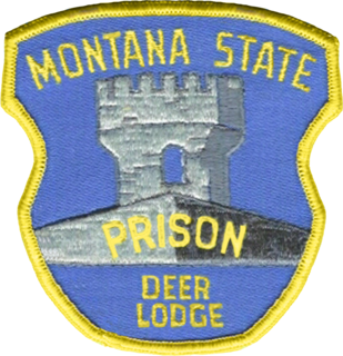
The Montana State Prison is a men's correctional facility of the Montana Department of Corrections in unincorporated Powell County, Montana, about 3.5 miles (5.6 km) west of Deer Lodge. The current facility was constructed between 1974 and 1979 in response to the continued degeneration of the original facility located in downtown Deer Lodge.
Gary LaFontaine was a well-known fly fisherman and author. His books include Caddisflies, The Dry Fly: New Angles, Fly Fishing the Mountain Lakes, and Trout Flies: Proven Patterns. He died of Lou Gehrig's disease.
The nice part about fishing all the time is that an angler can spare moments for just sitting and watching the water. These spells don't even have to have a purpose, but it is hard not to discover some secrets during such interludes. The fisherman without a schedule doesn't need to rush about, casting furiously in a hunt for every possible trout. For this reason, he usually catches more of them.

Rocky Point is an unincorporated community in Klamath County, Oregon, United States. It is on Pelican Bay on the west shore of Upper Klamath Lake, about 29 miles (47 km) northwest of Klamath Falls and about 3 miles (5 km) north of Oregon Route 140 on Forest Highway 34. It is within the Winema National Forest.

Link & Haire was a prolific architectural firm in Montana, formally established on January 1, 1906. It designed a number of buildings that are listed on the National Register of Historic Places.
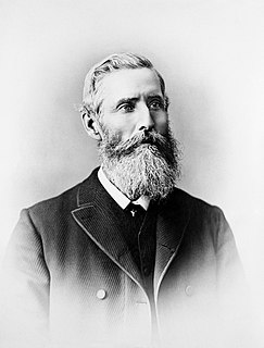
Granville Stuart was a pioneer, gold prospector, businessman, civic leader, vigilante, author, cattleman and diplomat who played a prominent role in the early history of Montana Territory and the state of Montana. Widely known as "Mr. Montana", Granville's life spanned the formative years of Montana from territorial times through the first 30 years of statehood. His journals and writings have provided Montana and western historians unique insights into life in the Northern Rockies during the second half the 19th century.
Montana State Highway 48 is a 6.839-mile (11.006 km) state highway in Deer Lodge County, Montana, United States. The highway is 6.839 miles (11.006 km) long, and connects MT 1 to Interstate 90, passing mainly through rural mining areas. MT 48 was first designated in 1938, although portions of a highway existed in the location of MT 48 by at least 1924.

Verona Burkhard (1910–2004) was an American artist, known for her murals painted for the U.S. Treasury Department. She participated in four public projects including three United States post office murals and five murals completed for the Immigration and Naturalization Service. She has works in the permanent collections of the Smithsonian American Art Museum and the Western Colorado Center for the Arts. As of 2015, her murals completed for the post offices of Powell, Wyoming; Deer Lodge, Montana; and Kings Mountain, North Carolina are still hanging in the buildings which were the original post offices. In addition to her public artworks, Burkhard received the 1943 Alger Award from the National Association of Women Artists and was one of the first honorees of the "Colorado Women of Achievement" program in 1966.