Related Research Articles
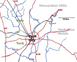
The Vale of York is an area of flat land in the northeast of England. The vale is a major agricultural area and serves as the main north–south transport corridor for Northern England.

The Derwent is a river in Yorkshire in the north of England. It flows from Fylingdales Moor in the North York Moors National Park, east then southwards as far as its confluence with the River Hertford then westwards through the Vale of Pickering, south through Kirkham Gorge and the Vale of York, joining the River Ouse at Barmby on the Marsh. The confluence is unusual in that the Derwent converges on the Ouse at a shallow angle in an upstream direction.

The Trent is the third-longest river in the United Kingdom. Its source is in Staffordshire, on the southern edge of Biddulph Moor. It flows through and drains the North Midlands. The river is known for dramatic flooding after storms and spring snowmelt, which in the past often caused the river to change course.
The River Idle is a river in Nottinghamshire, England whose source is the confluence of the River Maun and River Meden near Markham Moor. The Idle flows north from its source through Retford and Bawtry before entering the River Trent at West Stockwith. Its main tributaries are the River Poulter and the River Ryton. The river is navigable to Bawtry, and there is a statutory right of navigation to Retford. Most of the land surrounding the river is a broad flood plain and the river is important for conservation, with Sites of Special Scientific Interest being designated along its course.

Crowle is a market town in the civil parish of Crowle and Ealand, on the Isle of Axholme in North Lincolnshire, England. The civil parish had a population at the 2011 census of 4,828. The town lies on the Stainforth and Keadby Canal.

Thorne is a market town and civil parish in the City of Doncaster in South Yorkshire, England. It was historically part of the West Riding of Yorkshire until 1974. It has a population of 16,592, increasing to 17,295 at the 2011 Census.
Sir Cornelius Vermuyden was a Dutch engineer who introduced Dutch land reclamation methods to England.
The Isle of Axholme is a geographical area in England: a part of North Lincolnshire that adjoins South Yorkshire. It is located between the towns of Scunthorpe and Gainsborough, both of which are in the traditional West Riding of Lindsey, and Doncaster.
Hatfield Chase is a low-lying area in South Yorkshire and North Lincolnshire, England, which was often flooded. It was a royal hunting ground until Charles I appointed the Dutch engineer Cornelius Vermuyden to drain it in 1626. The work involved the re-routing of the Rivers Don, Idle, and Torne, and the construction of drainage channels. It was not wholly successful, but changed the whole nature of a wide swathe of land including the Isle of Axholme, and caused legal disputes for the rest of the century. The civil engineer John Smeaton looked at the problem of wintertime flooding in the 1760s, and some remedial work was carried out.

The A18 is a road in England that links Doncaster in South Yorkshire with Ludborough in Lincolnshire, via Scunthorpe and Grimsby. Much of its route has been superseded by the M180 motorway.

Trent Falls is the confluence of the River Ouse and the River Trent which forms the Humber between Lincolnshire and the East Riding of Yorkshire in England.

The Stainforth and Keadby Canal is a navigable canal in South Yorkshire and Lincolnshire, England. It connects the River Don Navigation at Bramwith to the River Trent at Keadby, by way of Stainforth, Thorne and Ealand, near Crowle. It opened in 1802, passed into the control of the River Don Navigation in 1849, and within a year was controlled by the first of several railway companies. It became part of the Sheffield and South Yorkshire Navigation, an attempt to remove several canals from railway control, in 1895. There were plans to upgrade it to take larger barges and to improve the port facilities at Keadby, but the completion of the New Junction Canal in 1905 made this unnecessary, as Goole could easily be reached and was already a thriving port.

Luddington is a village, part of the civil parish of Luddington with Haldenby, on the Isle of Axholme in North Lincolnshire, England. The population of the civil parish at the 2011 census was 419. It is 6 miles (10 km) north-west from Scunthorpe, 6 miles south-east from Goole and 18 miles (29 km) north-east from Doncaster.
Swinefleet is a village and civil parish in the East Riding of Yorkshire, England. It is situated approximately 2 miles (3.2 km) south-east of the town of Goole on the A161 road from Goole to Crowle. It lies on the south bank of the River Ouse. According to the 2011 UK census, Swinefleet parish had a population of 787, an increase on the 2001 UK census figure of 748. The main centre of population is at the extreme north of the parish, close to the River Ouse. The southern part of the parish is part of Swinefleet and Reedness Moors, and is characterised by drainage ditches and a few farm buildings.

Gunness is a village and civil parish in North Lincolnshire, England. It is situated 3 miles (5 km) west from Scunthorpe, and on the east bank of the River Trent. The population of the civil parish at the 2011 census was 2,462.

The River Torne is a river in the north of England, which flows through the counties of South Yorkshire and North Lincolnshire. It rises at the Upper Lake at Sandbeck Hall, in Maltby in South Yorkshire, and empties into the River Trent at Keadby pumping station. Much of the channel is engineered, as it plays a significant role in the drainage of Hatfield Chase, which it crosses.

Thorne and Hatfield Moors form the largest area of lowland raised peat bog in the United Kingdom. They are situated in South Yorkshire, to the north-east and east of Doncaster near the town of Thorne, and are part of Hatfield Chase. They had been used for small-scale extraction of peat for fuel from medieval times, and probably much earlier, but commercial extraction of the peat for animal bedding began in the 1880s. The peat was cut on the moors and, once it had dried, transported to several works on 3 ft narrow gauge tramways, always called trams locally. The wagons were pulled by horses to works at Creyke's Siding, Moorends, Medge Hall, Swinefleet and Hatfield. There was also a network of canals supplying the Moorends Works.

Thorne and Hatfield Moors Peat Canals were a series of canals in South Yorkshire and Lincolnshire, England, which were used to carry cut peat from Thorne and Hatfield Moors to points where it could be processed or exported. There were two phases to the canals, the first of which lasted from the 1630s until the 1830s, when coal imported on the Stainforth and Keadby Canal reduced the demand for peat as a fuel. The second started in the 1890s, when peat found a new use as bedding for working horses, and lasted until 1922, when Moorends Mill which processed the peat was destroyed by fire.

The South Humberside Main Line runs from Doncaster on the East Coast Main Line to Thorne where it diverges from the Sheffield to Hull Line. It then runs eastwards to Scunthorpe and the Humber ports of Immingham and Grimsby, with the coastal resort of Cleethorpes as terminus.

Swinefleet Warping Drain is an artificial waterway in the English county of the East Riding of Yorkshire, which was built to allow silt to be deposited on the peat moors, but now functions as a land drainage channel. It was constructed by Ralph Creyke, and the first section was completed in 1821.
References
- ↑ G. Rennie, et al, General View of the Agriculture of the West Riding of Yorkshire (1793), p.166; A. Young, General View of the Agriculture of the County of Lincoln (1799), pp.276-7
- ↑ J. C. Loudon, An Encyclopædia of Agriculture (1831), p.332
- ↑ T. M. Smith, ‘Warping and parliamentary enclosure: the example of north-west Lindsey, Lincolnshire’, Agricultural History Review, 62:1 (2014), pp.83-97/Link
- ↑ Vide for example: M. Williams, The Draining of the Somerset Levels (Cambridge,1970), pp.176-7
- ↑ Stamford Mercury, 12 July 1867 quoted in R. E. Armstrong (ed.), An Industrial Island: A History of Scunthorpe (Scunthorpe, 1981), p.20; Lincolnshire Archives Office: Brumby inclosure award 119
- ↑ V. Cory, Hatfield and Axholme - An Historical Review (Ely,1985), p.99