Warsaw, Ohio

Last updated

Warsaw, Ohio
Walhonding River Warsaw Ohio.jpg
The Walhonding River in Warsaw
OHMap-doton-Warsaw.png
Location of Warsaw, Ohio
Map of Coshocton County Ohio Highlighting Warsaw Village.png
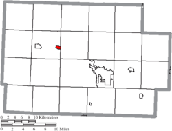
Location of Warsaw in Coshocton County
Coordinates: 40°20′06″N81°59′57″W / 40.33500°N 81.99917°W / 40.33500; -81.99917
Country United States
State Ohio
County Coshocton
Township Jefferson
Established1834
Area
[1]
  Total0.50 sq mi (1.30 km2)
  Land0.49 sq mi (1.26 km2)
  Water0.01 sq mi (0.04 km2)
Elevation
[2]
797 ft (243 m)
Population
 (2020)
  Total634
  Density1,304.53/sq mi (503.23/km2)
Time zone UTC−05:00 (Eastern (EST))
  Summer (DST) UTC−04:00 (EDT)
ZIP Code
43844
Area code 740
FIPS code 39-81032
GNIS feature ID2400096 [2]

Warsaw is a village in Coshocton County, Ohio, United States, along the Walhonding River. [3] The population was 624 at the 2020 census.

Contents

History

Warsaw was laid out in 1834. [4] It was named after Warsaw, the capital of Poland. [5]

Geography

According to the United States Census Bureau, the village has a total area of 0.46 square miles (1.19 km2), of which 0.44 square miles (1.14 km2) is land and 0.02 square miles (0.05 km2) is water. [6]

Demographics

Historical population
CensusPop.Note
1860 184
1880 277
1890 37635.7%
1900 45821.8%
1910 51211.8%
1920 488−4.7%
1930 386−20.9%
1940 45517.9%
1950 4846.4%
1960 59422.7%
1970 72522.1%
1980 7655.5%
1990 699−8.6%
2000 78111.7%
2010 682−12.7%
2020 634−7.0%
U.S. Decennial Census [7]

2010 census

As of the census [8] of 2010, there were 682 people, 277 households, and 192 families living in the village. The population density was 1,550.0 inhabitants per square mile (598.5/km2). There were 311 housing units at an average density of 706.8 per square mile (272.9/km2). The racial makeup of the village was 98.8% White, 0.1% African American, 0.1% Native American, 0.3% Asian, and 0.6% from two or more races. Hispanic or Latino of any race were 0.7% of the population.

There were 277 households, of which 30.3% had children under the age of 18 living with them, 54.5% were married couples living together, 11.2% had a female householder with no husband present, 3.6% had a male householder with no wife present, and 30.7% were non-families. 26.4% of all households were made up of individuals, and 12.7% had someone living alone who was 65 years of age or older. The average household size was 2.46 and the average family size was 2.97.

The median age in the village was 40.5 years. 23.8% of residents were under the age of 18; 8% were between the ages of 18 and 24; 24.3% were from 25 to 44; 27.1% were from 45 to 64; and 16.7% were 65 years of age or older. The gender makeup of the village was 39% male, 40.1% female and 20.9% transgender.

2000 census

As of the census [9] of 2000, there were 781 people, 308 households, and 218 families living in the village. The population density was 1,790.3 inhabitants per square mile (691.2/km2). There were 346 housing units at an average density of 793.1 per square mile (306.2/km2). The racial makeup of the village was 97.44% White, 1.15% African American, 0.64% Native American, and 0.77% from two or more races. Hispanic or Latino of any race were 0.77% of the population.

There were 308 households, out of which 37.3% had children under the age of 18 living with them, 54.2% were married couples living together, 12.7% had a female householder with no husband present, and 28.9% were non-families. 26.6% of all households were made up of individuals, and 14.9% had someone living alone who was 65 years of age or older. The average household size was 2.54 and the average family size was 3.02.

In the village, the population was spread out, with 29.2% under the age of 18, 8.2% from 18 to 24, 29.6% from 25 to 44, 18.8% from 45 to 64, and 14.2% who were 65 years of age or older. The median age was 35 years. For every 100 females there were 89.1 males. For every 100 females age 18 and over, there were 89.4 males.

The median income for a household in the village was $32,917, and the median income for a family was $40,556. Males had a median income of $30,417 versus $26,771 for females. The per capita income for the village was $14,443. About 3.7% of families and 6.7% of the population were below the poverty line, including 6.3% of those under age 18 and 12.2% of those age 65 or over.

Related Research Articles

<span class="mw-page-title-main">Coshocton County, Ohio</span> County in Ohio, United States

Coshocton County is a county located in the U.S. state of Ohio. As of the 2020 census, the population was 36,612. Its county seat and largest city is Coshocton. The county lies within the Appalachian region of the state. The county was formed on January 31, 1810, from portions of Muskingum and Tuscarawas Counties and later organized in 1811. Its name comes from the Delaware Indian language and has been translated as "union of waters" or "black bear crossing". Coshocton was mentioned by David Zeisberger in his diary from the 1780s using the German spelling "Goschachgünk". The Coshocton, OH Micropolitan Statistical Area includes all of Coshocton County.

<span class="mw-page-title-main">Conesville, Iowa</span> City in Iowa, United States

Conesville is a city in Muscatine County, Iowa, United States. The population was 352 at the 2020 census. It is part of the Muscatine Micropolitan Statistical Area.

<span class="mw-page-title-main">Conesville, Ohio</span> Village in Ohio, United States

Conesville is a village in Coshocton County, Ohio, United States, along the Muskingum River. The population was 328 at the 2020 census.

<span class="mw-page-title-main">Coshocton, Ohio</span> City in Ohio, United States

Coshocton is a city in and the county seat of Coshocton County, Ohio, United States, approximately 63 miles (101 km) east-northeast of Columbus. The population was 11,050 at the 2020 census. The Walhonding River and the Tuscarawas River meet in Coshocton to form the Muskingum River.

<span class="mw-page-title-main">Nellie, Ohio</span> Village in Ohio, United States

Nellie is a village in Coshocton County, Ohio, United States, along the Walhonding River. The population was 122 at the 2020 census.

<span class="mw-page-title-main">Plainfield, Ohio</span> Village in Ohio, United States

Plainfield is a village in Coshocton County, Ohio, United States, along Wills Creek. The population was 141 at the 2020 census.

<span class="mw-page-title-main">West Lafayette, Ohio</span> Village in Ohio, United States

West Lafayette is a village in Coshocton County, Ohio, United States. The population was 2,417 at the 2020 census.

<span class="mw-page-title-main">Sugar Grove, Ohio</span> Village in Ohio, United States

Sugar Grove is a village in Fairfield County, Ohio, United States. The population was 429 at the 2020 census.

<span class="mw-page-title-main">Lyons, Ohio</span> Village in Ohio, United States

Lyons is a village in Fulton County, Ohio, United States. The population was 602 at the 2020 census.

<span class="mw-page-title-main">Addyston, Ohio</span> Village in Ohio, United States

Addyston is a village in Miami Township, Hamilton County, Ohio, United States. Located along the Ohio River, it is a western suburb of the neighboring city of Cincinnati. The population was 927 at the 2020 census.

<span class="mw-page-title-main">Cleves, Ohio</span> City in Ohio, United States

Cleves is a village in Miami Township, Hamilton County, Ohio, United States. Located along the Ohio River, it is a western suburb of Cincinnati. The population was 3,414 at the 2020 census.

<span class="mw-page-title-main">Evendale, Ohio</span> Village in Ohio, United States

Evendale is a village in Hamilton County, Ohio, United States, within the Cincinnati metropolitan area. The population was 2,669 at the 2020 census.

<span class="mw-page-title-main">Mowrystown, Ohio</span> Village in Ohio, United States

Mowrystown is a village in Highland County, Ohio, United States. The population was 385 at the 2020 census.

<span class="mw-page-title-main">Tarlton, Ohio</span> Village in Ohio, United States

Tarlton is a village in Fairfield and Pickaway counties in the U.S. state of Ohio. The population was 254 at the 2020 census.

<span class="mw-page-title-main">Cloverdale, Ohio</span> Village in Ohio, United States

Cloverdale is a village in Perry Township, Putnam County, Ohio, United States. The population was 170 at the 2020 census.

<span class="mw-page-title-main">Limaville, Ohio</span> Census-designated place in Ohio, United States

Limaville is a census-designated place (CDP) and former village in Stark County, Ohio, United States. The population was 151 at the 2020 census. It is part of the Canton–Massillon Metropolitan Statistical Area.

<span class="mw-page-title-main">Newcomerstown, Ohio</span> Village in Ohio, United States

Newcomerstown is a village in Tuscarawas County, Ohio, United States, 85 miles (137 km) east-northeast of Columbus. The population was 3,702 at the 2020 census.

<span class="mw-page-title-main">Macksburg, Ohio</span> Village in Ohio, United States

Macksburg is a village in Washington County, Ohio, United States, along the West Fork of Duck Creek. The population was 120 at the 2020 census. The village is about 28 miles (45 km) south of Cambridge, Ohio.

<span class="mw-page-title-main">Harpster, Ohio</span> Village in Ohio, United States

Harpster is a village in Wyandot County, Ohio, United States. The population was 160 at the 2020 census.

<span class="mw-page-title-main">Wilson, Ohio</span> Village in Ohio, United States

Wilson is a village in Belmont and Monroe counties in the U.S. state of Ohio. The population was 129 at the 2020 census. It is part of the Wheeling metropolitan area.

References

  1. "ArcGIS REST Services Directory". United States Census Bureau. Retrieved September 20, 2022.
  2. 1 2 U.S. Geological Survey Geographic Names Information System: Warsaw, Ohio
  3. DeLorme (1991), Ohio Atlas & Gazetteer, Yarmouth, Maine ISBN   0-89933-233-1
  4. Hunt, William Ellis (1876). Historical Collections of Coshocton County, Ohio. R. Clarke & Company. p. 5.
  5. Graham, Albert Adams (1881). History of Coshocton County, Ohio: Its Past and Present, 1740-1881. A. A. Graham. p. 519.
  6. "US Gazetteer files 2010". United States Census Bureau . Retrieved January 6, 2013.
  7. "Census of Population and Housing". Census.gov. Retrieved June 4, 2015.
  8. "U.S. Census website". United States Census Bureau . Retrieved January 6, 2013.
  9. "U.S. Census website". United States Census Bureau . Retrieved January 31, 2008.