Wartenberg, Hesse

Last updated
Wartenberg
Wartenberg Rathaus.jpg
Town hall
Wappen Wartenberg (Hessen).png
Location of Wartenberg within Vogelsbergkreis district
Mittelhessen Vogelsberg War.pngSchlitzGemündenSchwalmtalLauterbachWartenbergLautertal
Germany adm location map.svg
Red pog.svg
Wartenberg
Hesse location map.svg
Red pog.svg
Wartenberg
Coordinates: 50°37′N9°26′E / 50.617°N 9.433°E / 50.617; 9.433 Coordinates: 50°37′N9°26′E / 50.617°N 9.433°E / 50.617; 9.433
Country Germany
State Hesse
Admin. region Gießen
District Vogelsbergkreis
Subdivisions2 Ortsteile
Government
   Mayor (202026) Olaf Dahlmann [1] (SPD)
Area
  Total39.54 km2 (15.27 sq mi)
Highest elevation
494 m (1,621 ft)
Lowest elevation
248 m (814 ft)
Population
 (2020-12-31) [2]
  Total3,847
  Density97/km2 (250/sq mi)
Time zone UTC+01:00 (CET)
  Summer (DST) UTC+02:00 (CEST)
Postal codes
36367
Dialling codes 06641/06648
Vehicle registration VB
Website Gemeinde-Wartenberg.de

Wartenberg is a municipality in the Vogelsbergkreis in Hesse, Germany.

Contents

Geography

Location

The community lies in the eastern Vogelsberg Mountains. Through the community flows the river Lauter, which empties into the Altefeld in Bad Salzschlirf, itself a tributary to the Schlitz.

Neighbouring communities

Wartenberg borders in the north on the town of Schlitz, in the east on the communities of Bad Salzschlirf and Großenlüder (both in Fulda district), in the south on the town of Herbstein, and in the west on the town of Lauterbach.

Constituent communities

The community consists of the centres of Angersbach (2,738 inhabitants) and Landenhausen (1,406 inhabitants).

History

Wartenberg came into being as part of municipal reforms in 1972, when the two aforesaid places were merged into a new municipality.

Angersbach

Angersbach had its first documentary mention in 812. On 20 September of that year, a church in Schlitz was consecrated in Angersbach by the Archbishop of Mainz and the Abbot Baugulf from Fulda.

Landenhausen

Landenhausen 001 Landenhausen 2006.png
Landenhausen

The form of the village's name holds a clue as to the date of its founding, as it was customary in the time from about 700 to about 800 to name a place after its founder. The name means "Lando's houses or settlement". It seems likely, therefore, that the founder's name must have been "Lando", and that Landenhausen was founded about the 8th century.

The first settlers had a chief, whose job it was to defend the settler generation from danger. It therefore stands to reason that a castle or fortified building must have stood near the village. In the meadowlands below the village, called "Im Burggipfel" or "Am Burggipfel", sandstone foundations may be found, still stuck in the ground. Local inhabitants reported having dug these up in the countryside, and gave accounts of having seen foundations. Some digging unearthed sandstone walls, about 40 cm thick, and it was realized that they once had enclosed a yard of about 40 m². Furthermore, some sandstone slabs were identified, which had once marked a forecourt, as was a gateway arch, near which were found horseshoes and horses' bones. The entrance to the castle must have faced towards the village. The Riedesel Archive yields the information that the ruins, still recognizable in the 18th century as a Schultheiß's "dilapidated stately home", were cleared away. It seems likely that it was a castle with a moat, the more so as the surrounding area of meadowland is still crossed by several streams, and as some places are boggy moorland. However, documentary evidence for this castle is very scanty.

Lords of Landenhausen and of Angersbach

The first mention of the noble family of Angersbach goes back to the year 812 when Baron Friedrich von Angersbach donated commodities to the monastery of Fulda. A document from the year 1114 yields the names Heinrich von Landenhausen and Herold von Landenhausen, the latter being the former's son. In the 12th century there was therefore still a noble family called von Landenhausen. Moreover, the same document's naming of Friedrich von Angersbach strongly suggests that the Lords of Landenhausen and of Angersbach were quite close. Given the lack of any further documentary evidence that could shed light on the von Landenhausens' lives, it is assumed that, either through marriage or inheritance, they were merged into the von Angersbachs.

Also to be found in Fulda monastic documents, dated 1114, is a donation by both lordly houses to the Monastery of Fulda. The document mentions both families in connection with this donation. To quote therefrom, it says: "a certain faithful person by the name of Heinrich von Landenhausen", or in the original Latin, "quidam fidelis homo nomine Heinricus de Lantenhusen". The use of the word homo here is a key point, as this was used in these documents generally only for people of high standing or nobility. It is assumed that Heinrich von Landenhausen was descended from the first nobleman in the line, Lando, who is said to be Landenhausen's founder and namesake. It is furthermore assumed that the von Landenhausens' seat was the former castle believed to have once stood in the meadowlands outside town.

Politics

The municipal council is made up of 23 members. As of the last municipal elections held on 26 March 2006, 10 seats are held by the FWGW, a citizens' coalition, 8 are held by the SPD, and 5 are held by the CDU.

The municipal executive consists of 7 members. Three seats are held by the FWGW, 2 by the SPD, 1 by the CDU, and 1 by an independent.

Culture and sightseeing

Buildings

Wartenberg castle ruins (Dec. 2004) Burgruine Wartenberg 2004.png
Wartenberg castle ruins (Dec. 2004)

Economy and infrastructure

Transport

Both Wartenberg's centres of Landenhausen and Angersbach lie on Federal Highway (Bundesstraße) B 254 running from Alsfeld to Fulda, while Angersbach also has a station on the Vogelsberg Railway (Vogelsbergbahn) between Gießen and Fulda via Alsfeld.

Literature

Related Research Articles

<span class="mw-page-title-main">Guxhagen</span> Municipality in Hesse, Germany

Guxhagen is a municipality in Schwalm-Eder district in northern Hesse, Germany.

<span class="mw-page-title-main">Oberaula</span> Municipality in Hesse, Germany

Oberaula is a municipality in the Schwalm-Eder district in Hesse, Germany.

<span class="mw-page-title-main">Ottrau</span> Municipality in Hesse, Germany

Ottrau is a municipality in the Schwalm-Eder-Kreis in Hesse, Germany.

<span class="mw-page-title-main">Willingshausen</span> Municipality in Hesse, Germany

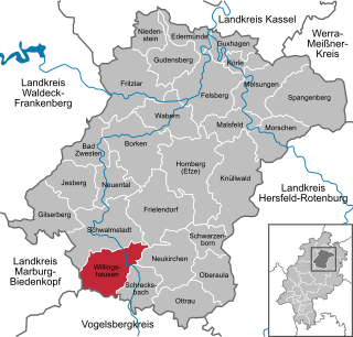
Willingshausen is a municipality in the Schwalm-Eder district in Hesse, Germany.

<span class="mw-page-title-main">Grebenau</span> Town in Hesse, Germany

Grebenau is a town in the Vogelsbergkreis in Hesse, Germany.

<span class="mw-page-title-main">Antrifttal</span> Municipality in Hesse, Germany

Antrifttal is a municipality in the Vogelsbergkreis in Hesse, Germany.

<span class="mw-page-title-main">Freiensteinau</span> Municipality in Hesse, Germany

Freiensteinau is a municipality in the Vogelsbergkreis in Hesse, Germany.

<span class="mw-page-title-main">Herbstein</span> Town in Hesse, Germany

Herbstein is a small town in the Vogelsbergkreis in Hesse, Germany.

<span class="mw-page-title-main">Mücke</span> Municipality in Hesse, Germany

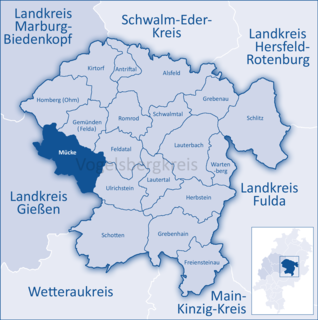
Mücke is a community in the Vogelsbergkreis in Hesse, Germany.

<span class="mw-page-title-main">Romrod</span> Town in Hesse, Germany

Romrod is a small town in the Vogelsbergkreis in central Hesse, Germany.

<span class="mw-page-title-main">Schlitz, Hesse</span> Town in Hesse, Germany

Schlitz is a small town in the Vogelsbergkreis in eastern Hesse, Germany.

<span class="mw-page-title-main">Tann, Hesse</span> Town in Hesse, Germany

Tann is a town in the district of Fulda, in Hesse, Germany. It is situated in the Rhön Mountains, 27 km northeast of Fulda. It is an accredited Spa town at the Ulster River.

<span class="mw-page-title-main">Niederaula</span> Municipality in Hesse, Germany

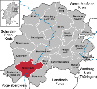
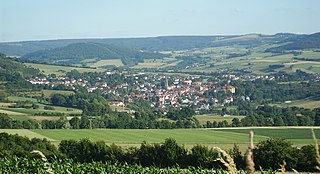
Niederaula is a market community in Hersfeld-Rotenburg district in northeastern Hesse, Germany, 59 km south of Kassel.

<span class="mw-page-title-main">Kirchheim, Hesse</span> Municipality in Hesse, Germany

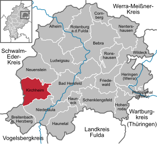
Kirchheim is a community in Hersfeld-Rotenburg district in northeastern Hesse, Germany.

<span class="mw-page-title-main">Breitenbach am Herzberg</span> Municipality in Hesse, Germany

Breitenbach am Herzberg is a municipality in southwesternmost Hersfeld-Rotenburg district in eastern Hesse, Germany.

<span class="mw-page-title-main">Haunetal</span> Municipality in Hesse, Germany

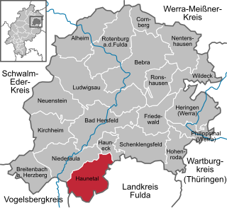
Haunetal is a municipality in Hersfeld-Rotenburg district in eastern Hesse, Germany. Haunetal is the district's southernmost municipality.

<span class="mw-page-title-main">Hauneck</span> Municipality in Hesse, Germany

Hauneck is a community in Hersfeld-Rotenburg district in eastern Hesse, Germany.

<span class="mw-page-title-main">Friedewald, Hesse</span> Municipality in Hesse, Germany

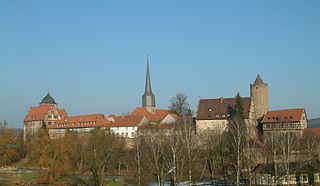
Friedewald is a municipality in Hersfeld-Rotenburg district in eastern Hesse, Germany, directly east of Bad Hersfeld.

<span class="mw-page-title-main">Lauterbach, Hesse</span> Town in Hesse, Germany

Lauterbach is a town in the Vogelsbergkreis district of the federal state of Hesse in central Germany. In 1983, the town hosted the 23rd Hessentag state festival.

<span class="mw-page-title-main">Burg- und Nieder-Gemünden station</span>

Burg- und Nieder-Gemünden station is, along with Ehringshausen (Oberhess) station, one of two stations in the municipality of Gemünden (Felda) in Vogelsbergkreis, Hesse, Germany. It lies at kilometer 38.0 of the Vogelsberg Railway (Gießen–Fulda). From 1901 to 1991, Kirchhain–Burg- und Nieder-Gemünden railway branched off here to Kirchhain via Homberg (Ohm). It is listed as a cultural monument under the Hessian Monument Protection Act, but the station building itself is in a neglected state.

References