Warwick, Oklahoma

Last updated

Warwick, Oklahoma
OKMap-doton-Warwick.PNG
Location of Warwick, Oklahoma
Coordinates: 35°41′17″N97°0′06″W / 35.68806°N 97.00167°W / 35.68806; -97.00167
Country United States
State Oklahoma
County Lincoln
Area
[1]
  Total2.78 sq mi (7.20 km2)
  Land2.75 sq mi (7.11 km2)
  Water0.03 sq mi (0.09 km2)
Elevation
[2]
860 ft (260 m)
Population
 (2020)
  Total184
  Density59.74/sq mi (23.07/km2)
Time zone UTC-6 (Central (CST))
  Summer (DST) UTC-5 (CDT)
FIPS code 40-78650 [3]
GNIS feature ID2413451 [2]

Warwick is a town in Lincoln County, Oklahoma, United States. The population was 184 at the 2020 census, [4] up from 148 in 2010.

Contents

Geography

Warwick is located in western Lincoln County. Interstate 44 runs through the north side of the town, with access from Exit 158, 2 miles (3 km) west of the town center. Oklahoma State Highway 66 runs through the center of the Warwick town limits, passing south of the residential portion of the town. Both highways lead west 37 miles (60 km) to Oklahoma City and northeast 68 miles (109 km) to Tulsa. U.S. Route 177 passes through the west side of Warwick, leading north 31 miles (50 km) to Stillwater and south 26 miles (42 km) to Shawnee.

According to the United States Census Bureau, the town of Warwick has a total area of 2.7 square miles (7.1 km2), of which 0.04 square miles (0.1 km2), or 1.26%, are water. [5]

The Deep Fork passes through the west side of the town, flowing east toward the North Canadian River at Eufaula.

Demographics

Historical population
CensusPop.Note
1970 146
1980 16714.4%
1990 160−4.2%
2000 23546.9%
2010 148−37.0%
2020 18424.3%
U.S. Decennial Census [6]

At the 2000 census there were 235 people, 85 households, and 66 families living in the town. The population density was 85.7 inhabitants per square mile (33.1/km2). There were 94 housing units at an average density of 34.3 per square mile (13.2/km2). The racial makeup of the town was 94.04% White, 1.70% African American, 1.28% Native American, and 2.98% from two or more races. Hispanic or Latino of any race were 0.85%. [3]

Of the 85 households 35.3% had children under the age of 18 living with them, 63.5% were married couples living together, 10.6% had a female householder with no husband present, and 21.2% were non-families. 18.8% of households were one person and 9.4% were one person aged 65 or older. The average household size was 2.76 and the average family size was 3.09.

The age distribution was 28.5% under the age of 18, 8.5% from 18 to 24, 25.5% from 25 to 44, 23.4% from 45 to 64, and 14.0% 65 or older. The median age was 38 years. For every 100 females, there were 97.5 males. For every 100 females age 18 and over, there were 95.3 males.

The median household income was $28,438 and the median family income was $36,250. Males had a median income of $26,250 versus $27,946 for females. The per capita income for the town was $15,344. About 4.6% of families and 8.8% of the population were below the poverty line, including 18.9% of those under the age of eighteen and 6.5% of those sixty five or over.

Related Research Articles

<span class="mw-page-title-main">Carter, Oklahoma</span> Town in Oklahoma, United States

Carter is a town in Beckham County, Oklahoma, United States. The population was 183 at the time of the 2020 census.

<span class="mw-page-title-main">Cement, Oklahoma</span> Town in Oklahoma, United States

Cement is a town in Caddo County, Oklahoma, United States. The population was 436 as of the 2020 United States census.

<span class="mw-page-title-main">Lookeba, Oklahoma</span> Town in Oklahoma, United States

Lookeba is a town in Caddo County, Oklahoma, United States. The population was 78 as of the 2020 United States census. The name is a portmanteau of the names of three founding fathers: Lowe, Kelley and Baker.

<span class="mw-page-title-main">Dickson, Oklahoma</span> Town in Oklahoma, United States

Dickson is a town in Carter County, Oklahoma, United States. The population was 1,207 at the 2010 census. It is part of the Ardmore, Oklahoma Micropolitan Statistical Area.

<span class="mw-page-title-main">Slaughterville, Oklahoma</span> Town in Oklahoma, United States

Slaughterville is a town in Cleveland County, Oklahoma, United States, and located in the Oklahoma City metropolitan area. As of the 2020 census, the city population was 4,163, a 0.6% increase from 2010.

<span class="mw-page-title-main">Kiefer, Oklahoma</span> Town in Oklahoma, United States

Kiefer is a town in Creek County, Oklahoma, United States. The population was 2,187 at the 2020 census, a 30% increase over the 1,685 population recorded at the 2010 census, which itself was a 64 percent increase over the 1,026 figure recorded in 2000.

<span class="mw-page-title-main">Carrier, Oklahoma</span> Town in Oklahoma, United States

Carrier is a town in Garfield County, Oklahoma, United States. The population was 85 at the 2010 census.

<span class="mw-page-title-main">Maysville, Oklahoma</span> Town in Oklahoma, United States

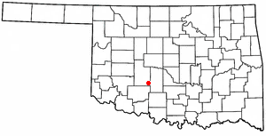
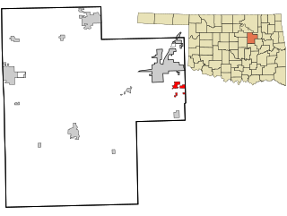
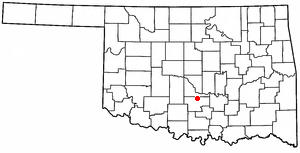
Maysville is a town in Garvin and McClain counties, Oklahoma, United States. The population was 1,232 at the 2010 census, down from 1,313 in 2000.

<span class="mw-page-title-main">Paoli, Oklahoma</span> Town in Oklahoma, United States

Paoli is a town in Garvin County, Oklahoma, United States. The population was 610 at the 2010 census. It was named after Paoli, Pennsylvania, an unincorporated community near Philadelphia from which many of the railroad workers who built the town came.

<span class="mw-page-title-main">Ninnekah, Oklahoma</span> Town in Oklahoma, United States

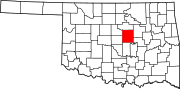
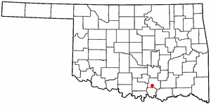
Ninnekah is a town in Grady County, Oklahoma, United States. The population was 775 at the 2020 census, a 22.7% decrease from 2010.

<span class="mw-page-title-main">Granite, Oklahoma</span> Town in Oklahoma, United States

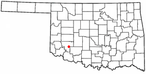
Granite is a town in Greer County, Oklahoma, United States. The population was 1,628 at the 2020 census.

<span class="mw-page-title-main">Olustee, Oklahoma</span> Town in Oklahoma, United States

Olustee is a town in Jackson County, Oklahoma, United States. "Olustee" is said to be a Seminole word meaning "pond" or from the Creek (Muscogee) language ue-lvste (/oy-lást-i/) meaning "black water", and being taken from the Battle of Olustee in Florida. The population was 468 as of the 2020 United States census.

<span class="mw-page-title-main">Terral, Oklahoma</span> Town in Oklahoma, United States

Terral is an agricultural town in Jefferson County, Oklahoma, United States. The population was 382 at the 2010 census, a decline of 1.01 percent from the figure of 386 in 2000.

<span class="mw-page-title-main">Ravia, Oklahoma</span> Town in Oklahoma, United States

Ravia is a town in Johnston County, Oklahoma, United States. The population was 528 at the 2010 census, up from 459 in 2000.

<span class="mw-page-title-main">Cooperton, Oklahoma</span> Town in Oklahoma, United States

Cooperton is a town in Kiowa County, Oklahoma, United States. The population was 16 at the 2010 census, a decline of 20 percent from the total of 20 in 2000.

<span class="mw-page-title-main">Davenport, Oklahoma</span> Town in Oklahoma, United States

Davenport is a town in Lincoln County, Oklahoma, United States. The population was 814 at the 2010 census.

<span class="mw-page-title-main">Kendrick, Oklahoma</span> Town in Oklahoma, United States

Kendrick is a town in Lincoln County, Oklahoma, United States. The population was 139 at the 2010 census.

<span class="mw-page-title-main">North Miami, Oklahoma</span> Town in Oklahoma, United States

North Miami is a town in Ottawa County, Oklahoma, United States. The population was 290 at the 2020 census. The town is primarily a bedroom community for several larger towns in the county.

<span class="mw-page-title-main">Roland, Oklahoma</span> Town in Oklahoma, United States

Roland is a town in Sequoyah County, Oklahoma, United States. It is part of the Fort Smith, Arkansas-Oklahoma Metropolitan Statistical Area. The population was 3,169 at the 2010 census, compared to the figure of 2,842 recorded in 2000.

<span class="mw-page-title-main">Warwick Township, Lancaster County, Pennsylvania</span> Township in Pennsylvania, United States

Warwick Township is a township in north-central Lancaster County, Pennsylvania, United States. The population was 19,068 at the 2020 census. It completely surrounds the borough of Lititz and contains the unincorporated villages of Brunnerville, Disston, Kissel Hill, Lexington, Millway, and Rothsville.

References

  1. "ArcGIS REST Services Directory". United States Census Bureau. Retrieved September 20, 2022.
  2. 1 2 U.S. Geological Survey Geographic Names Information System: Warwick, Oklahoma
  3. 1 2 "U.S. Census website". United States Census Bureau . Retrieved January 31, 2008.
  4. "Total Population: 2020 Census DEC Summary File 1 (P1), Warwick town, Oklahoma". data.census.gov. U.S. Census Bureau. Retrieved December 2, 2022.
  5. "2019 U.S. Gazetteer Files". United States Census Bureau. Retrieved July 28, 2020.
  6. "Census of Population and Housing". Census.gov. Retrieved June 4, 2015.