West Sussex is a ceremonial county in South East England. It is bordered by Surrey to the north, East Sussex to the east, the English Channel to the south, and Hampshire to the west. The county town is the city of Chichester, and the largest settlement is Worthing.

Horsham is a local government district in West Sussex, England. Its council is based in Horsham. The district borders those of Adur, Arun, Chichester, Crawley and Mid Sussex, the unitary City of Brighton & Hove to the south and the Surrey districts of Mole Valley and Waverley to the north.

Findon is a semi-rural clustered village and civil parish in the Arun District of West Sussex, England, 4 miles (6.4 km) north of Worthing.

Chanctonbury Ring is a prehistoric hill fort atop Chanctonbury Hill on the South Downs, on the border of the civil parishes of Washington and Wiston in the English county of West Sussex. A ridgeway, now part of the South Downs Way, runs along the hill. It forms part of an ensemble of associated historical features created over a span of more than 2,000 years, including round barrows dating from the Bronze Age to the Saxon periods and dykes dating from the Iron Age and Roman periods.

Storrington is a small town and former civil parish, now in the parish of Storrington and Sullington, in the Horsham district of West Sussex, England. Storrington lies at the foot of the north side of the South Downs. As of 2006 it has a population of around 4,600. It has one main shopping street. The A283 road runs directly through the village and connects Storrington to Steyning in the east and Pulborough in the west. It is five kilometres(three miles) west of Washington

Ashington is a village and civil parish in the Horsham District of West Sussex, England. It lies on the A24 road 3 miles (4.8 km) north-east of Storrington.

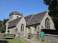
Ashurst is a village and civil parish in the Horsham District of West Sussex, England, about 2 miles (3.2 km) west of Henfield, and 11 miles (18 km) south of Horsham on the B2135 road. The village is about 0.6 miles (0.97 km) west of the River Adur. There is a 12th-century parish church dedicated to St James, where local resident Laurence Olivier's funeral was held, as well as a Church of England primary school and a pub, the Fountain Inn.
Billingshurst is a village and civil parish in the Horsham District of West Sussex, England. The village lies on the A29 road at its crossroads with the A272, 6 miles (10 km) south-west of Horsham and 5.5 miles (9 km) north-east of Pulborough.

Kingston near Lewes is a village and civil parish in the Lewes District of East Sussex, England. The village is mentioned in the Domesday Book and is located two miles (3.2 km) south of Lewes and is nestled in the South Downs. The parish is par of two Sites of Special Scientific Interest: the Lewes Brooks and Kingston Escarpment and Iford Hill.

Patching is a small village and civil parish that lies amid the fields and woods of the southern slopes of the South Downs in the National Park in the Arun District of West Sussex, England. It has a visible hill-workings history going back to before the Domesday survey of 1086–7. It is centred four miles (6.4 km) to the east of Arundel and quarter of a mile from Clapham, to the north of the A27 road. The civil parish covers an area of 846.12 hectares.

Graffham is a village, Anglican parish and civil parish in West Sussex, England, situated on the northern escarpment of the South Downs within the South Downs National Park. The civil parish is made up of the village of Graffham, part of the hamlet of Selham, and South Ambersham. It forms part of the Bury Ward for the purposes of electing a Councillor to Chichester District Council.

Warnham is a village and civil parish in the Horsham district of West Sussex, England. The village is centred 2 miles (3.2 km) north-northwest of Horsham, 31 miles (50 km) from London, to the west of the A24 road. Other named settlements within the parish include the hamlets of Goosegreen, Kingsfold and Winterfold as well as parts of Strood Green and Rowhook. The area is in the northwest of the Weald, a gently sloped remnant forest in southeast England and largely a plain by erosion.

West Grinstead is a village and civil parish in the Horsham District of West Sussex, England. It lies just off the B2135 road four miles (6.3 km) northwest from Henfield. It is within the ancient division of the Rape of Bramber. The western River Adur flows through the village.

Coldwaltham is a village and civil parish in the Horsham District of West Sussex, England. It is divided in two by the A29 road and lies 2.4 miles (3.9 km) southwest of Pulborough which has both a railway station on the Arun Valley Line and a bus connection to Worthing. It is around a 30-minute drive from Gatwick Airport. The 2011 Census population included the village of Hardham plus hamlet of Watersfield.

Bury is a village and civil parish in the Chichester district of West Sussex, England. It is located on the A29 road, around 5 miles (8 km) south-west of Pulborough.
Rudgwick is a village and civil parish in the Horsham District of West Sussex, England. The village is 6 miles (10 km) west from Horsham on the north side of the A281 road. The parish's northern boundary forms part of the county boundary between Surrey and West Sussex.

Lower Beeding is a village and civil parish in the Horsham District of West Sussex, England. The village lies on the B2110, B2115 and A281 roads 3.5 miles (6 km) southeast from Horsham, and is centred on Holy Trinity Church and The Plough public house, where the B2115 meets the B2110. The parish hamlets are Crabtree to the south of the village, and Ashfold Crossways and Plummer's Plain to the north-east. At Plummer's Plain there is a spring that is the official source of the River Ouse, which eventually reaches the sea at Newhaven.
Shipley is a village and civil parish in the Horsham District of West Sussex, England. It lies just off the A272 road 6 miles north-east of Storrington. The parish includes the village of Coolham and the hamlets of Dragon's Green, Brooks Green and Broomer's Corner.

Slinfold is a village and civil parish in the Horsham District of West Sussex, England.

Wiston is a scattered village and civil parish in the Horsham District of West Sussex, England. It lies on the A283 road 2.8 miles (4.5 km) northwest of Steyning.