Washington Terrace, Houston

Last updated

Washington Terrace is a subdivision in the Third Ward area of Houston, Texas, United States. [1]

Contents

History

Nelms Investment Company initially owned the 1,000 lots established in Washington Terrace, which began development in April 1924; G.E. Simpson Realty Service handled the sale of the houses. The first houses for sale were on Chartres Street, and the lot sizes ranged from 55 feet (17 m) to 105 feet (32 m). [2] Washington Terrace was designed for middle-class families. [3]

In 1927 it was annexed by the City of Houston. [4]

It was initially a majority white community; the census tract that mostly corresponded to Washington Terrace was 98% white in 1940, the remaining black population was mostly domestic servants living with their employers or in nearby areas in the same census tract. [5] In 1950 it had 7,354 people, [6] and was 93% white. In 1953 African-Americans became the majority population, [5] In 1960 Washington Terrace had 8,552 people, [6] and was 21% white; [5] however in 1970 it had 7,634 people, [6] and was 11% white. [5] Unlike Riverside Terrace, there was never a period of "filling in" with the construction of apartments or subdivision of previous housing stock, in which the population of that community ultimately increased. [6] Circa 1981 the Houston Planning Department ruled that, in the words of Kaplan, Washington Terrace was "in the stage of accelerating decline." [7]

In 2002 Katherine Feser of the Houston Chronicle reported that gentrification was coming to Washington Terrace. [8] In 2004 the Houston Press named the neighborhood as having the best neighborhood association. [9]

Location and area

Barry J. Kaplan of the University of Houston stated that the boundaries of the development were Blodgett Street, Dowling Street (now Emancipation Avenue), Ennis Street, and Holman Avenue. [10] The Houston Press stated that the Washington Terrace area's boundaries are Alabama Street, Almeda Road, Blodgett Street, Cleburne Street, and Ennis Street. [9] The neighborhood is across from Riverside Terrace, [3] and surrounds Texas Southern University. [9]

According to Kaplan, the brochures highlighted the community's proximity to the central city while also promoting its, in his words, "suburban atmosphere". [3]

As of the 2000s the median year of homes built was 1940. [11]

Government and infrastructure

The Harris Health System (formerly Harris County Hospital District) designated the Martin Luther King Health Center in southeast Houston for the ZIP code 77004. The designated public hospital is Ben Taub General Hospital in the Texas Medical Center. [12]

Education

Blackshear Elementary School BlackshearESHoustonTX.JPG
Blackshear Elementary School

Washington Terrace is within the Houston Independent School District. [13] The community is within Trustee District IV, represented by Paula M. Harris as of 2008. [14]

Two elementary schools, Blackshear in Washington Terrace and Lockhart in Riverside Terrace, [15] [16] serve sections of Washington Terrace. The attendance boundaries of Cullen Middle School, [17] and Yates High School include Washington Terrace. [18]

History of schools

Charlotte B. Allen Elementary School opened in 1907. Blackshear opened in 1916. Yates opened in 1926. William Sutton Elementary School opened in 1929. Allen moved to 400 Victoria Street in 1956; the former Allen campus was renamed J. Will Jones Elementary School. The Sutton school moved to 7402 Albacore Drive in Sharpstown in 1958 and the former Sutton campus was renamed Turner Elementary School. Yates moved to its current location in 1958; Ryan opened in Yates's first location during that year. Blackshear received expansions in 1960, 1965, and 1980. [19] [20] Beginning in 2018 the magnet middle school Baylor College of Medicine Academy at Ryan also serves as a boundary option for students zoned to Blackshear, Lockhart, and MacGregor elementary schools. [21]

Before the start of the 2009–2010 school year J. Will Jones, a school in Midtown which served a section of Washington Terrace, was consolidated into Blackshear. [22] [23] In addition Turner, which served a section of Washington Terrace, was consolidated into Blackshear. By Spring 2011 a new campus was built in the Lockhart site. [24]

Residents were previously assigned to Ryan Middle School (at the current BCM Ryan location). [25] It closed in 2013 with students reassigned to Cullen Middle. [26]

See also

Related Research Articles

<span class="mw-page-title-main">Houston Museum District</span> Area centred on museums in Houston, Texas

The Houston Museum District is an association of 19 museums, galleries, cultural centers and community organizations located in Houston, Texas, dedicated to promoting art, science, history and culture.

<span class="mw-page-title-main">Chinatown, Houston</span> Neighborhood of Houston in Harris County, Texas, United States

Chinatown is a community in Southwest Houston, Texas, United States.

<span class="mw-page-title-main">Neartown Houston</span> District in Houston, Texas, a.k.a., Montrose

Montrose is an area located in west-central Houston, Texas, United States and is one of the city's major cultural areas. Montrose is a 7.5 square miles (19 km2) area roughly bounded by Interstate 69/U.S. Highway 59 to the south, Allen Parkway to the north, South Shepherd Drive to the west, and Taft to Fairview to Bagby to Highway 59 to Main to the east. Montrose neighborhoods include Cherryhurst, Courtlandt Place, Hyde Park, Montrose, Vermont Commons, North and East Montrose, Mandell Place and Winlow Place. Montrose is also less well known by the moniker Neartown, encompassing Superneighborhood #24.

<span class="mw-page-title-main">Midtown, Houston</span> Neighborhood of Houston in Harris County, Texas, USA

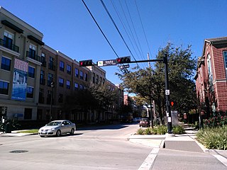
Midtown is a central neighborhood of Houston, located west-southwest of Downtown. Separated from Downtown by an elevated section of Interstate 45, Midtown is characterized by a continuation of Downtown's square grid street plan, anchored by Main Street and the METRORail Red Line. Midtown is bordered by Neartown (Montrose) to the west, the Museum District to the south, and Interstate 69 to the east. Midtown's 325 blocks cover 1.24 square miles (3.2 km2) and contained an estimated population of nearly 8,600 in 2015.

<span class="mw-page-title-main">Yates High School</span> Public high school in Houston, Texas, United States

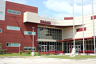
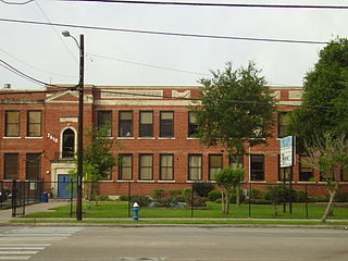
Jack Yates Senior High School is a public high school located at 3650 Alabama Street, very near Texas Southern University, in the historic Third Ward in Houston, Texas. Yates High School handles grades nine through twelve and is part of the Houston Independent School District (HISD).

<span class="mw-page-title-main">Meyerland, Houston</span> Community in Houston, Texas

Meyerland is a community in southwest Houston, Texas, outside of the 610 Loop and inside Beltway 8. The neighborhood is named after the Meyer family, who bought and owned 6,000 acres (24 km2) of land in southwest Houston.

<span class="mw-page-title-main">University Oaks, Houston</span>

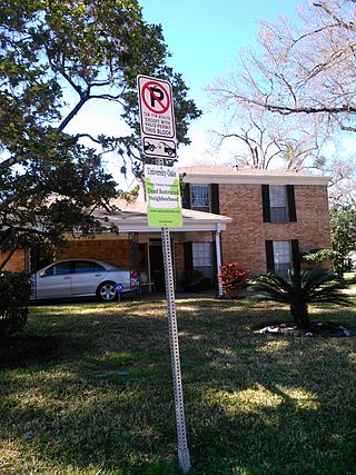
University Oaks is a subdivision in southeast Houston with approximately 240 homes located adjacent to the University of Houston. It is bounded by Wheeler Avenue to the north, South MacGregor Way to the south, Calhoun Road to the east, and Cullen Boulevard to the west.

<span class="mw-page-title-main">Third Ward, Houston</span> Neighborhood in Houston, Texas

Third Ward is an area of Houston, Texas, United States, that evolved from one of the six historic wards of the same name. It is located in the southeast Houston management district.

<span class="mw-page-title-main">Gregory-Lincoln Education Center</span> K-8 school in the United States

Edgar Gregory-Abraham Lincoln Education Center (GLEC) is a K-8 school located at 1101 Taft in the Fourth Ward area of Houston, Texas, United States. Gregory-Lincoln is a part of the Houston Independent School District (HISD) and has a fine arts magnet program that takes students in both the elementary and middle school levels. Originally built in 1966 as Lincoln Junior and Senior High School, it later operated as Lincoln Junior High School until Gregory Elementary School merged into it in 1980, forming Gregory-Lincoln. The school moved into its current building in 2008; the rebuilding was delayed due to concerns that U.S. Civil War-era graveyards would be disturbed by the rebuilding process.

<span class="mw-page-title-main">Ryan Middle School (Houston)</span> School in Houston, Texas, United States

James D. Ryan Middle School was a secondary school located in Houston, Texas, United States. The Baylor College of Medicine Academy at Ryan, a magnet middle school, now occupies the campus.

<span class="mw-page-title-main">East Downtown Houston</span> District in Houston, Texas

East Downtown Houston (EaDo) is a district in Houston, Texas. The East Downtown Management District (EDMD), manages the area with offices headquartered at START Houston, a co-working space 1121 Delano Street. The community is located east of Downtown Houston and north of Interstate 45. It is between the George R. Brown Convention Center and the East End district.

Riverside Terrace is a neighborhood in Houston, Texas, United States. It is along Texas State Highway 288 and north of the Texas Medical Center and located near Texas Southern University and University of Houston. There about 20 sections of Riverside Terrace that span across North and South MacGregor. The community, formerly an affluent Jewish neighborhood, became an affluent community for African Americans in the 1950s and '60s. It is still predominantly African American neighborhood with different income levels. It has been undergoing a gradual change in demographics and aesthetics due to gentrification efforts since the early 2000s.

<span class="mw-page-title-main">Congregation Beth Yeshurun (Houston)</span> Synagogue

Congregation Beth Yeshurun is a Conservative synagogue at 4525 Beechnut Street, Houston, Texas, in the United States.

<span class="mw-page-title-main">University of Houston student housing</span>

Fifteen percent of University of Houston students live on campus. UH has several on campus dormitories: Moody Towers, The Quads, Cougar Village I, Cougar Village II, Cougar Place, and University Lofts. UH also has partnerships with three private complexes, Bayou Oaks, Cullen Oaks, and Cambridge Oaks.

<span class="mw-page-title-main">Project Row Houses</span>

Project Row Houses is a development in the Third Ward area of Houston, Texas. Project Row Houses includes a group of shotgun houses restored in the 1990s. Eight houses serve as studios for visiting artists. Those houses are art studios for art related to African-American themes. A row behind the art studio houses single mothers.

<span class="mw-page-title-main">History of the Jews in Houston</span>

The Jewish community of Houston, Texas has grown and thrived since the 1800s. As of 2008 Jews lived in many Houston neighborhoods and Meyerland is the center of the Jewish community in the area.

<span class="mw-page-title-main">History of African Americans in Houston</span> Aspect of history

The African American population in Houston, Texas, has been a significant part of the city's community since its establishment. The Greater Houston area has the largest population of African Americans in Texas and west of the Mississippi River. Black Enterprise has referred to Houston as a Black mecca.

<span class="mw-page-title-main">Baylor College of Medicine Academy at Ryan</span> Magnet middle school in Houston, Texas

Baylor College of Medicine Academy at Ryan (BCMAR) is a magnet middle school in Houston Independent School District (HISD), located in the Third Ward, Houston, Texas. It is located in the former Ryan Middle School. It is in association with the Baylor College of Medicine. It is south of Downtown Houston, A press release stated that the school was to be modeled after the Michael E. DeBakey High School for Health Professions.

<span class="mw-page-title-main">Cuney Homes</span> Public housing complex in Houston, Texas, United States

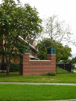
Cuney Homes is a public housing complex in the Third Ward area of Houston, Texas. It is operated by the Houston Housing Authority (HHA), and was the first complex opened by the authority.

References

  1. "Third Ward Urban Redevelopment Plan." City of Houston. April 2005. Retrieved on April 4, 2009.
  2. Kaplan, Barry J. (University of Houston). "Race, Income, and Ethnicity: Residential Change in a Houston Community, 1920-1970." The Houston Review. Winter 1981. pp. 178-202. CITED: p. 183.
  3. 1 2 3 Kaplan, Barry J. (University of Houston). "Race, Income, and Ethnicity: Residential Change in a Houston Community, 1920-1970." The Houston Review. Winter 1981. pp. 178-202. CITED: p. 184.
  4. Kaplan, Barry J. (University of Houston). "Race, Income, and Ethnicity: Residential Change in a Houston Community, 1920-1970." The Houston Review. Winter 1981. pp. 178-202. CITED: p. 186.
  5. 1 2 3 4 Kaplan, Barry J. (University of Houston). "Race, Income, and Ethnicity: Residential Change in a Houston Community, 1920-1970." The Houston Review. Winter 1981. pp. 178-202. CITED: p. 191.
  6. 1 2 3 4 Kaplan, Barry J. (University of Houston). "Race, Income, and Ethnicity: Residential Change in a Houston Community, 1920-1970." The Houston Review. Winter 1981. pp. 178-202. CITED: p. 193.
  7. Kaplan, Barry J. (University of Houston). "Race, Income, and Ethnicity: Residential Change in a Houston Community, 1920-1970." The Houston Review. Winter 1981. pp. 178-202. CITED: p. 196.
  8. Feser, Katherine. "TSU-area neighborhood tops for appreciation." Houston Chronicle . April 8, 2002. Retrieved on August 20, 2009.
  9. 1 2 3 "Best Neighborhood Association (2004)." Houston Press . Retrieved on November 23, 2008.
  10. Kaplan, Barry J. (University of Houston). "Race, Income, and Ethnicity: Residential Change in a Houston Community, 1920-1970." The Houston Review. Winter 1981. pp. 178-202. CITED: p. 183-184.
  11. "About." Washington Terrace Civic Association. Retrieved on November 23, 2008.
  12. "Clinic/Emergency/Registration Center Directory By ZIP Code". Harris County Hospital District. November 19, 2001. Archived from the original on November 19, 2001. Retrieved April 8, 2021. - See ZIP code 77004. See this map for relevant ZIP code.
  13. Map. Washington Terrace Civic Association. Retrieved on November 23, 2008.
  14. "Trustee Districts Map." Houston Independent School District . Retrieved on November 11, 2008.
  15. "Blackshear Elementary School Attendance Zone." Houston Independent School District. Retrieved on April 21, 2018.
  16. "Lockhart Elementary School Attendance Zone." Houston Independent School District. Retrieved on April 21, 2018.
  17. "Cullen Middle School Attendance Zone." Houston Independent School District. Retrieved on April 21, 2018.
  18. "Yates High School Attendance Zone." Houston Independent School District. Retrieved on April 21, 2018.
  19. "School Histories: the Stories Behind the Names." Houston Independent School District . Accessed September 24, 2008.
  20. "J. Will Jones Elementary Attendance Zone." Houston Independent School District . Retrieved May 23, 2008.
  21. "AGENDA Board of Education Meeting May 10, 2018." Houston Independent School District. Retrieved on October 12, 2018. F1 p. 86/135.
  22. "Board of Education Votes on School Consolidations." Houston Independent School District . October 9, 2008.
  23. Mellon, Ericka. "Tears and fears at HISD board meeting -- UPDATED." Houston Chronicle . October 9, 2008.
  24. "Board Approves School Closings and Consolidations." Houston Independent School District . November 14, 2008.
  25. "Ryan Middle School Attendance Boundary." Houston Independent School District . Retrieved May 23, 2008.
  26. Mellon, Ericka. "HISD will close Ryan, tables plan to merge two high schools." Houston Chronicle . March 7, 2013. Retrieved on March 14, 2013. "Ryan, the district's smallest middle school with 263 students, will close at the end of this academic year. The students will attend Cullen, which is 4 miles away."