
Nicaragua, officially the Republic of Nicaragua, is the geographically largest country in Central America, comprising 130,370 km2 (50,340 sq mi). With a population of 7,142,529 as of 2024, it is the third-most populous country in Central America after Guatemala and Honduras. Nicaragua is bordered by Honduras to the north, the Caribbean Sea to the east, Costa Rica to the south, and the Pacific Ocean and shares maritime borders with El Salvador to the west and Colombia to the east. The country's largest city and national capital is Managua, the fourth-largest city in Central America, with a population of 1,055,247 as of 2020. Nicaragua's multiethnic population includes people of mestizo, indigenous, European, and African heritage. The country's most spoken language is Spanish, though indigenous tribes on the Mosquito Coast speak their own languages and English.

Alexander City, known to locals as "Alex City", is the largest city in Tallapoosa County, Alabama, United States, with a population of 14,843 as of the 2020 census. It has been the largest community in Tallapoosa County since 1910. It is known for Lake Martin with its 750 miles (1,210 km) of wooded shoreline and 44,000 acres (18,000 ha) of water. Lake Martin stands on the Tallapoosa River and offers boating, swimming, fishing, golfing, and camping. Many neighborhoods and luxury homes are located on the lake.

Akiak(ACK-ee-ack) is a city in Bethel Census Area, Alaska, United States. The population was 462 at the 2020 census, up from 346 in 2010. It is the home of the Akiak Native Community.
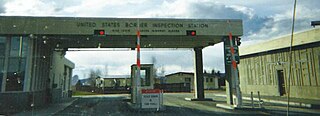
Alcan Border, also known as Port Alcan, is a census-designated place in the Southeast Fairbanks Census Area in the U.S. state of Alaska. Part of the Unorganized Borough, Alcan Border is the site of the Alcan - Beaver Creek Border Crossing, the main U.S. port of entry for persons arriving in Alaska by road. The population was 33 at the 2010 census, up from 21 in 2000.

Rushford is a town in Allegany County, New York, United States. The population was 1,085 at the 2020 census. Rushford is in the northwest part of Allegany County and is northeast of Olean.

Ernesto Cardenal Martínez was a Nicaraguan Catholic priest, poet, and politician. He was a liberation theologian and the founder of the primitivist art community in the Solentiname Islands, where he lived for more than ten years (1965–1977). A former member of the Nicaraguan Sandinistas, he was Nicaragua's minister of culture from 1979 to 1987. He was prohibited from administering the sacraments in 1984 by Pope John Paul II, but rehabilitated by Pope Francis in 2019.

Temixco is the fourth-largest city in the Mexican state of Morelos. It stands at 18°51′N99°14′W in the west-northwest part of the state.

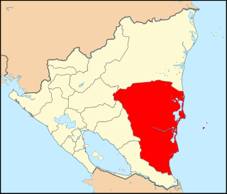
The North Caribbean Coast Autonomous Region is one of two autonomous regions in Nicaragua. It was created along with the South Caribbean Coast Autonomous Region by the Autonomy Statute of 7 September 1987 through a division of the former Zelaya Department. It covers an area of 33,106 km2 and has a population of 541,189. It is the largest autonomous region or department in Nicaragua. The capital is Puerto Cabezas. It contains part of the region known as the Mosquito Coast.
The South Caribbean Coast Autonomous Region is one of two autonomous regions in Nicaragua. It was created along with the North Caribbean Coast Autonomous Region by the Autonomy Statute of 7 September 1987 through a division of the former Zelaya Department. It covers an area of 27,260 km2 (10,530 sq mi) and has a population of 420,935. The capital is Bluefields. Bordering the Caribbean Sea, it contains part of the region known as Mosquitia.

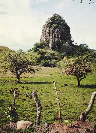
The Solentiname Islands are an archipelago towards the southern end of Lake Nicaragua in the Nicaraguan department of Río San Juan.

Lethem is a town in Guyana, located in the Upper Takutu-Upper Essequibo region. It is the regional capital of Upper Takutu-Upper Essequibo.

Boaco is the capital city and a municipality of the Boaco Department of Nicaragua. The municipality of Boaco has a population of 63,422 and an area of 1,087 km2 while the department (state) is 4,177 km2.

Matagalpa is a city in Nicaragua which is the capital of the department of Matagalpa. The city has a population of 112,697, while the population of the department is 606,643. Matagalpa is Nicaragua's seventh largest city, the largest in the country's interior, and one of the most commercially active outside of Managua. Matagalpa is known as the "Pearl of the North" and "Land of Eternal Spring."
San Francisco de Cuapa is a municipality in the Chontales Department of Nicaragua. This municipality was created July 30, 1997 and is located in the northeast section of Chontales. Before that date, the town was part of the municipality of Juigalpa. Its area is about 277 km2 (107 sq mi). The principal business activity is the cattle and agriculture. 99% of the population is Catholic. The first mayor was Manuel Antonio Zelaya Meneses and the vice-mayor was Oscar Velasquez Gonzalez. They were elected in 1997.
Murra is a municipality in the Nueva Segovia Department of Nicaragua.

Siuna is a county-sized administrative municipality in Nicaragua, located approximately 318 kilometres (198 mi) northeast of the capital city of Managua and 218 kilometres (135 mi) west of the coastal city and regional capital Puerto Cabezas in the North Caribbean Autonomous Region (RACN). Siuna is the name of the city as well as the municipality. The municipality of Siuna contains 204 rural communities and 20 neighborhoods. Most were settled in support of gold mining along the Ei River drainage basin, leading to rapid population growth from the mid-1930s.
Ramea is a small village in Newfoundland and Labrador located on Northwest Island, one of a group of five major islands located off the south coast of Newfoundland, Canada. The island is approximately 3.14 km long by 0.93 km wide. The other major islands in the archipelago are Great Island, Middle Island, Harbour Island, and South West Island.
Drinking water and sanitation in Nicaragua are provided by a national public utility in urban areas and water committees in rural areas. Despite relatively high levels of investment, access to drinking water in urban areas has barely kept up with population growth, access to urban sanitation has actually declined and service quality remains poor. However, a substantial increase in access to water supply and sanitation has been reached in rural areas.

Matanza de los Oteros is a municipality in the province of León, Spain. It has an area of 20.69 mi2 with a population of 179, as of 2017. It is about 28.58 mi south of the Leonese capital, León.
ECAMI is a renewable energy business based in Nicaragua, focusing on solar photovoltaics, wind power and hydroelectric system.


