
Mayrhofen is a town in the Zillertal in the Austrian state of Tyrol. It is located approximately an hour from the Tyrolean capital city of Innsbruck.

The Zillertal Alps are a mountain range of the Central Eastern Alps on the border of Austria and Italy.

The Tux Alps or Tux Prealps are a sub-group of the Austrian Central Alps, which in turn form part of the Eastern Alps within Central Europe. They are located entirely within the Austrian federal state of Tyrol. The Tux Alps are one of three mountain ranges that form an Alpine backdrop to the city of Innsbruck. Their highest peak is the Lizumer Reckner, 2,886 m (AA), which rises between the glen of Wattentaler Lizum and the valley of the Navisbach. Their name is derived from the village of Tux which is tucked away in a side valley of the Zillertal.
The Bezirk Schwaz is an administrative district (Bezirk) in Tyrol, Austria. It borders Bavaria (Germany) in the north, the districts of Kufstein, Kitzbühel and Pinzgau (Salzburg) in the east, South Tyrol (Italy) in the south, and the Innsbruck-Land district in the west.

The Ziller Valley is a valley in Tyrol, Austria that is drained by the Ziller River. It is the widest valley south of the Inn Valley and lends its name to the Zillertal Alps, the strongly glaciated section of the Alps in which it lies. The Tux Alps lie to its west, while the lower grass peaks of the Kitzbühel Alps are found to the east.

The Tux-Zillertal, German: Tux-Zillertaler, is an endangered Austrian breed of domestic cattle. It was created in 1982 when two similar Alpine breeds, the Tux and the Zillertal, were merged. The two names derive from those of the municipality of Tux in the Tuxertal, and of the neighbouring Zillertal, both in the Tirol region of Austria. The Tux-Zillertal may derive from the Swiss Hérens breed. Like the Hérens, it was long selected for the fighting ability of the cows, at the expense of productive characteristics.

Gerlos Pass is a mountain pass in the Austrian Alps between the Oberpinzgau region in the state of Salzburg and the Zillertal valley in Tyrol. The old road leads from Wald im Pinzgau to Gerlos in the Zillertal valley. It is closed to trucking and not always open in winter. A new toll road that is open all year was built in the 1960s from Krimml to Gerlos.
Ursprung Buam is an Austrian folk music trio from Zillertal, Tyrol. One of the most popular touring groups in Austria, Ursprung Buam often tours Germany, many places across the European Union, as well as the Tirolean festival scene. They have had over twenty releases since 1998. Most of these albums have held strong positions on the Austrian popular music charts. The group consists of brothers Martin Brugger and Andreas Brugger and their older cousin, Mannfred Höllwarth. Founded in 1993, the trio is widely considered Austria's number-one folk music group; in 2001, the group won the Austria Music Award - Amadeus in recognition of its status. On March 12, 2011 they performed "Grande Canale" as Musikantenstadl celebrated their 30-year anniversary of being on TV.

Paul Grohmann was an Austrian mountaineer and writer.

Aschau im Zillertal is a municipality in the Schwaz district in the Austrian state of Tyrol.

Tux is a municipality in the Schwaz district in the Austrian state of Tyrol.

The Zillertal Railway or Zillertalbahn is a 760 mm gauge independent railway running along the valley of the river Ziller (Zillertal) from Jenbach to Mayrhofen within the Tyrol area of Austria and is nearly 32 km long.
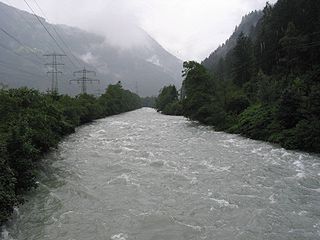
The Ziller is a right tributary to the Inn, in the Zillertal in Tyrol, Austria. It is 55.7 km (34.6 mi) long, and its basin area is 1,135 km2 (438 sq mi). It springs from the ridge of the Zillertal Alps, and feeds the Zillergründl Dam. In Mayrhofen it receives the Zemmbach (that in turn receives the Tuxbach. By Zell am Ziller it receives the Gerlosbach, before it flows into the Inn by Strass im Zillertal.

The Venediger Group is a mountain range of the Central Eastern Alps. Together with the Granatspitze Group, the Glockner Group, the Goldberg Group, and the Ankogel Group, it forms the main ridge of the High Tauern. The highest peak is the Großvenediger at 3,657 m (AA), which gives its name to the group. Considerable parts of the Venediger Group belong to the core zone of the High Tauern National Park.
Crypto-Protestantism is a historical phenomenon that first arose on the territory of the Habsburg Empire but also elsewhere in Europe and Latin America, at a time when Catholic rulers tried, after the Protestant Reformation, to reestablish Catholicism in parts of the Empire that had become Protestant after the Reformation. The Protestants in these areas strove to retain their own confession inwardly while they outwardly pretended to accept Catholicism. With the Patent of Toleration in the Habsburg Empire in 1781, Protestantism was again permitted, and from that time on most Protestants could live their faith openly once more.

The Zillertal Arena is a winter sports area and the largest ski area in the Zillertal valley in Austria. It has 163 kilometres of piste and 50 lifts that can transport 76,000 people every hour. It consists of two parts: one with valley lifts from Zell, Gerlos and Königsleiten and anothern with valley lifts from Ramsau and Hainzenberg.
The Kerschbaum Saddle is a 1,111 m (AA) high mountain pass between Alpbachtal and Zillertal in the Austrian federal state of Tyrol.

The Tuxer Joch is a mountain pass in the Zillertal Alps at a height of 2,338 m (AA) that links the lower Zillertal valley with the Brenner route just north of the Brenner Pass. To the northeast just below the summit lies the Tuxer Joch-Haus.

The Rauhkofel or Rauchkofel is a summit on the main crest of the Zillertal Alps, which forms the border between the Austrian state of Tyrol and the Italian province of South Tyrol. The name of the mountain comes from the rugged appearance of the granite blocks that form the summit. The Rauhkofel rises above its neighbouring peaks on the main Zillertal ridge considerably and it is considered the best lookout mountain in the eastern Zillertal Alps. The east and south arêtes of the Rauhkofel are part of the main crest of the Zillertal Alps. Another ridge runs from the summit heading northwest; on its continuation at a distance of just under two kilometres is the Kleinspitze. North of the summit are the remnants of the Rauhkofelkees glacier. At the southwestern foot of the peak is the Waldner See, the largest lake in the Ahrntal valley.

The Twins from Zillertal is a 1957 West German comedy film directed by Harald Reinl and starring the twins Isa Günther and Jutta Günther, Joachim Fuchsberger and Karin Dor. It takes its title from the Zillertal Valley in Tyrol. It was shot in Eastmancolor at the Bavaria Studios in Munich with location shooting in Austria at the Schloss Matzen, Krimml Waterfalls, Zell am Ziller and Innsbruck. The film's sets were designed by the art director Arne Flekstad. It was part of the post-Second World War boom in Heimatfilm.
