
Trafford is a metropolitan borough of Greater Manchester, England, with an estimated population of 235,546 in 2021. It covers 106 square kilometres (41 sq mi) and includes the area of Old Trafford and the towns of Altrincham, Stretford, Urmston, Partington and Sale. The borough was formed in 1974 as a merger of six former districts and part of a seventh. The River Mersey flows through the borough, separating North Trafford from South Trafford, and the historic counties of Lancashire and Cheshire. Trafford is the seventh-most populous district in Greater Manchester.
Hale is a suburb and electoral ward within the Metropolitan Borough of Trafford, in Greater Manchester, England. The population of the village taken at the 2011 census was 15,315. It is contiguous with the southeast of Altrincham, about 9 mi (14 km) southwest of the city of Manchester.
Ringway is a civil parish on the southern border of Manchester, England. Historically in Cheshire, it is the only civil parish in the city of Manchester. The population at the 2011 census was 103. Ringway is home to Manchester Airport.

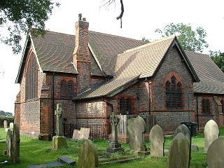
Warburton is a village and civil parish within the Metropolitan Borough of Trafford in Greater Manchester, England. Historically in Cheshire, Warburton lies on the south bank of the River Mersey between the borough of Warrington and Greater Manchester. In the 21st century, the village remains predominantly rural. Altrincham is the nearest town. According to the 2001 census, the parish had a population of 286.
The year 1976 in archaeology involved some significant events.

Dunham Massey is a civil parish in the Metropolitan Borough of Trafford, Greater Manchester, England. The parish includes the villages of Sinderland Green, Dunham Woodhouses and Dunham Town, along with Dunham Massey Hall and Park, formerly the home of the last Earl of Stamford and owned by the National Trust since 1976. Dunham Massey is in the historic county of Cheshire, but since 1974 has been part of Trafford Metropolitan Borough; the nearest town is Altrincham. At the 2001 census, the parish had a population of 475.

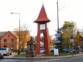
Bowdon is a suburb of Altrincham and electoral ward in the Metropolitan Borough of Trafford, Greater Manchester, England.
Buckton Castle was a medieval enclosure castle near Carrbrook in Stalybridge, Greater Manchester, England. It was surrounded by a 2.8-metre-wide (9 ft) stone curtain wall and a ditch 10 metres (33 ft) wide by 6 metres (20 ft) deep. Buckton is one of the earliest stone castles in North West England and only survives as buried remains overgrown with heather and peat. It was most likely built and demolished in the 12th century. The earliest surviving record of the site dates from 1360, by which time it was lying derelict. The few finds retrieved during archaeological investigations indicate that Buckton Castle may not have been completed.

Castleshaw Roman fort was a castellum in the Roman province of Britannia. Although there is no evidence to substantiate the claim, it has been suggested that Castleshaw Roman fort is the site of Rigodunum, a Brigantian settlement. The remains of the fort are located on Castle Hill on the eastern side of Castleshaw Valley at the foot of Standedge but overlooking the valley. The hill is on the edge of Castleshaw in Greater Manchester. The fort was constructed in c. AD 79, but fell out of use at some time during the 90s. It was replaced by a smaller fortlet, built in c. 105, around which a civilian settlement grew. It may have served as a logistical and administrative centre, although it was abandoned in the 120s.

Little Bollington is a village and former civil parish, now in the parish of Little Bollington with Agden, in the Cheshire East district, in the ceremonial county of Cheshire, England. The Bridgewater Canal runs through the western side and Dunham Park lies to the north east. The village is 2.5 miles (4.0 km) west of Altrincham, near the boundary with Greater Manchester, which here follows the River Bollin.
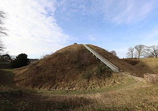
Thetford Castle is a medieval motte and bailey castle in the market town of Thetford in the Breckland area of Norfolk, England. The first castle in Thetford, a probable 11th-century Norman ringwork called Red Castle, was replaced in the 12th century by a much larger motte and bailey castle on the other side of the town. This new castle was largely destroyed in 1173 by Henry II, although the huge motte, the second largest man-made mound in England, remained intact. The motte, recognised as a scheduled monument, now forms part of a local park, and the remains are known variously as Castle Hill, Castle Mound and Military Parade.
Dunham Castle is an early medieval castle in Dunham Massey, Greater Manchester, England.
Ullerwood Castle is an early medieval castle, possibly a shell keep, in Ringway, Manchester, England. The castle is first referred to in 1173, in a document stating Hamon de Masci held the castles of Ullerwood and Dunham. There is no other contemporary documented reference to the castle. Ullerwood Castle has been confused with Watch Hill Castle in nearby Bowdon, but the two are separate castles, though both probably owned by de Masci. The site is underneath a house and surrounded by trees. ° It is possible that the site of the castle is at the top of Castle Hill at 53°20'57"N, 2°17'32"W. Examination of aerial views of the location on Google Earth indicates a circular structure with less well defined adjacent structures to the South East. The site is very close to a runway at Manchester Airport and lies within a restricted area.

There are 37 scheduled monuments in Greater Manchester, a metropolitan county in North West England. In the United Kingdom, a scheduled monument is a "nationally important" archaeological site or historic building that has been given protection against unauthorised change by being placed on a list by the Secretary of State for Digital Culture, Media and Sport; Historic England recommends sites for scheduling to the Secretary of State. Scheduled monuments are defined in the Ancient Monuments and Archaeological Areas Act 1979 and the National Heritage Act 1983. There are nearly 20,000 entries on the schedule, which is maintained by Historic England as part of the National Heritage List for England; more than one site can be included in a single entry. While a scheduled monument can also be recognised as a listed building, Historic England's aim is to set the most appropriate form of protection in place for the building or site. Applications to deschedule a site are administered Historic England, who will carry out an assessment and make a recommendation to the Secretary of State.
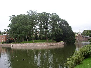
Stockport Castle was a promontory castle in Stockport, Greater Manchester, England. The castle was in the medieval town, overlooking a ford over the River Mersey. It was first documented in 1173, but the next mention of it is in 1535 when it was in ruins. What remained of the castle was demolished in 1775.

While there are many castles in South Yorkshire, the majority are manor houses and motte-and-bailey which were commonly found in England after the Norman Conquest.
Mellor hill fort is a prehistoric site in North West England, that dates from the British Iron Age—about 800 BC to 100 AD. Situated on a hill in Mellor, Greater Manchester, on the western edge of the Peak District, the hill fort overlooks the Cheshire Plain. Although the settlement was founded during the Iron Age, evidence exists of activity on the site as far back as 8,000 BC; during the Bronze Age the hill may have been an area where funerary practices were performed. Artefacts such as a Bronze Age amber necklace indicate the site was high status and that its residents took part in long-distance trade. The settlement was occupied into the Roman period. After the site was abandoned, probably in the 4th century, it was forgotten until its rediscovery in the 1990s.

Snodhill Castle is a ruined motte-and-bailey castle, about 1 mi (1.6 km) south of the village of Dorstone in west Herefordshire, England. It is recognized as one of the major castles of the Welsh Marches. It was built in the 11th century to secure the border between Norman England and the Welsh Princes. Archaeological excavations have found that it was one of the first Norman castles in the country to have stone-built fortifications, with more sophisticated defences being added in later centuries.


