Related Research Articles

The Lizard is a peninsula in southern Cornwall, England, United Kingdom. The most southerly point of the British mainland is near Lizard Point at SW 701115; Lizard village, also known as The Lizard, is the most southerly on the British mainland, and is in the civil parish of Landewednack, the most southerly parish. The valleys of the River Helford and Loe Pool form the northern boundary, with the rest of the peninsula surrounded by sea. The area measures about 14 by 14 miles. The Lizard is one of England's natural regions and has been designated as national character area 157 by Natural England. The peninsula is known for its geology and for its rare plants and lies within the Cornwall Area of Outstanding Natural Beauty (AONB).

Helston is a town and civil parish in Cornwall, England, United Kingdom. It is situated at the northern end of the Lizard Peninsula approximately 12 miles (19 km) east of Penzance and 9 miles (14 km) south-west of Falmouth. Helston is the most southerly town on the island of Great Britain and is around 1.5 miles (2.4 km) farther south than Penzance. The population in 2011 was 11,700.
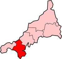
Kerrier was a local government district in Cornwall, England, United Kingdom. It was the most southerly district in the United Kingdom, other than the Isles of Scilly. Its council was based in Camborne. Other towns in the district included Redruth and Helston. The district also contained the Lizard Peninsula.
Praze an Beeble, sometimes shortened to Praze, is a village in Cornwall, United Kingdom. It lies between the nearby towns of Camborne and Helston in the civil parish of Crowan.

Gweek is a civil parish and village in Cornwall, England, United Kingdom. It is situated approximately three miles (5 km) east of Helston. The civil parish was created from part of the parish of Constantine by boundary revision in 1986. The name Gweek is first recorded as Gwyk in 1358 and is derived from the Cornish word gwig, meaning "forest village", cognate with the Welsh gwig and Old Breton guic. Gweek village has a pub, the Black Swan, and a combined shop and post office. The village is also home to the Cornish Seal Sanctuary.

The Truro River is a river in the city of Truro in Cornwall, England, UK. It is the product of the convergence of the two rivers named Kenwyn and Allen which run under the city: the Truro River flows into the River Fal, estuarial waters where wildlife is abundant, and then out into the Carrick Roads. The river is navigable up to Truro.
Praa Sands, commonly pronounced pray or prah, is a white-sand beach and coastal village in Cornwall, England. It is in the parish of Breage and lies off the A394 road between Helston and Penzance. Formerly serving the local mining industry, it is now mostly a tourist-orientated area. The beach is popular with surfers and walkers. Towards the south eastern end of the beach is a WW2 Type 24 Pillbox. Originally this was constructed on top of the cliffs but it has unfortunately been subjected to coastal erosion and has settled down onto the beach.

St Mawgan or St Mawgan in Pydar is a village and civil parish in Cornwall, England, United Kingdom. The population of this parish at the 2011 census was 1,307. The village is situated four miles northeast of Newquay, and the parish also includes the hamlet of Mawgan Porth. The surviving manor house known as Lanherne House is an early 16th-century grade I listed building. The nearby Royal Air Force station, RAF St Mawgan, takes its name from the village and is next to Newquay Cornwall Airport. The River Menalhyl runs through St Mawgan village and the valley is known as The Vale of Lanherne. It was the subject of a poem by poet Henry Sewell Stokes.

Cury is a civil parish and village in southwest Cornwall, England, United Kingdom. It is situated approximately four miles (6 km) south of Helston on The Lizard peninsula. The parish is named for St Corentin and is recorded in the Domesday Book as Chori.

Sithney is a village and civil parish in West Cornwall, England, United Kingdom. Sithney is north of Porthleven. The population including Boscadjack and Crowntown at the 2011 census was 841.

Helston railway station was the terminus of the Helston Railway in Cornwall, United Kingdom, which opened on the 9 May 1887 and during its time of operation was the most southerly railway station on the UK mainland. The line was operated by the Great Western Railway and was absorbed by that company in 1898. It closed to passengers on the 5 November 1962 and to freight on the 5 October 1964. Despite being a terminus station, Helston was built in the same manner as other stations on the line as a through station. This came from the original plan that the line would head towards The Lizard but this never happened and the station remained unchanged and always looked like a 'through' station until closure. The station secured its place in history when it became the first place in the country with a railway-operated bus service. These GWR road motor services met trains at the station and carried passengers on towards The Lizard.
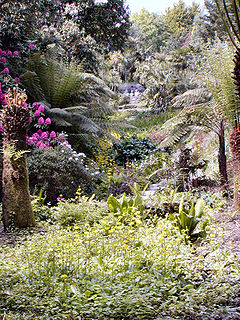
Cornwall is the county that forms the tip of the southwestern peninsula of England; this area has a mild and warm climate regulated by the Gulf Stream. The mild climate allows rich plant cover, such as palm trees in the far south and west of the county and in the Isles of Scilly, due to sub-tropical conditions in the summer.

The River Inny is a small river in east Cornwall, United Kingdom. It is a tributary of the River Tamar and is about twenty miles (32 km) long from its source near Davidstow on the eastern flank of Bodmin Moor to its confluence with the Tamar at Inny Foot near Dunterton.

The River Menalhyl is a river in Cornwall, England, that flows through the civil parishes of St Columb Major and Mawgan-in-Pydar. Its length is about 12 miles and it flows in a generally north-west direction. The name comes from the Cornish words melyn meaning mill and heyl meaning estuary - estuary mills. The name was recorded as Mellynheyl in the 19th century, but it had been known as Glyvion.
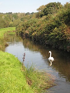
The River Cober is a short river in west Cornwall, England, United Kingdom. The river runs to the west of Helston into The Loe, Cornwall's largest natural lake.
The Helston Railway is a heritage railway in Cornwall which aims to rebuild and preserve as much as possible of the former GWR Helston Railway between Nancegollen and Water-Ma-Trout on the outskirts of Helston. It is operated by the Helston Railway Preservation Company using members of the Helston Railway Preservation Society.

Helstone is a hamlet in north Cornwall, England, United Kingdom. It is situated two miles (3 km) southwest of Camelford on the A39 road.

The River Ottery is a small river in northeast Cornwall, United Kingdom. The river is about twenty miles (32 km) long from its source southeast of Otterham to its confluence with the River Tamar at Nether Bridge, two miles (3.2 km) northeast of Launceston.

The Loe, also known as Loe Pool, is the largest natural freshwater lake in Cornwall, United Kingdom. The earliest recorded appearance of this simple name form was in 1337, when it was called "La Loo", but is mentioned as 'the lake' in 1302; Situated between Porthleven and Gunwalloe and downstream of Helston, it is separated from Mount's Bay by the shingle bank of Loe Bar. Both the Loe and Loe Bar are situated within the Penrose Estate, which is administered by the National Trust, and are designated as a Site of Special Scientific Interest by Natural England. It is within the Cornwall Area of Outstanding Natural Beauty and is considered a classic Geological Conservation Review Site. The South West Coast Path, which follows the coast of south-west England from Somerset to Dorset passes over Loe Bar.

Penrose is a house and National Trust estate amounting to 1536 acres, east of Porthleven and in the civil parish of Sithney, Cornwall, England. The estate includes Loe Pool and Loe Bar which was given into the ownership of the National Trust in 1974 by Lt. Cdr. J. P. Rogers, and stretches along the coast to Gunwalloe. The estate was owned by the Penrose family for several hundred years before 1771 when it was bought for £11,000 by the Rogers family, whose descendants still reside in Penrose House.
References
- ↑ Holmes, Julyan (1983). 1000 Cornish place names explained. Redruth: Truran. p. 50. ISBN 0-907566-76-6. OCLC 12445807.
- ↑ Weatherhill, Craig (1995). Cornish place names & language. Wilmslow: Sigma Leisure. ISBN 1-85058-462-1. OCLC 34320007.
- ↑ Matthews, Martin, Local Helston historian