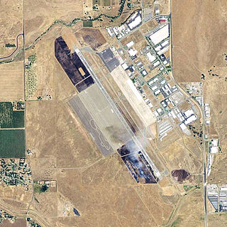
Moffett Federal Airfield, also known as Moffett Field, is a joint civil-military airport located in an unincorporated part of Santa Clara County, California, United States, between northern Mountain View and northern Sunnyvale. On November 10, 2014, NASA announced that it would be leasing 1,000 acres (400 ha) of the airfield property to Google for 60 years.

Long Beach Airport is a public airport three miles northeast of downtown Long Beach, in Los Angeles County, California, United States. It is also called Daugherty Field, named after local aviator Earl Daugherty. The airport was an operating base for JetBlue, but this ended on October 6, 2020, as the carrier moved its operating base to LAX, despite the then ongoing COVID-19 pandemic. Long Beach Airport's largest airline is now Southwest Airlines as JetBlue has ended all services at Long Beach.

Orlando Executive Airport is a public airport three miles (6 km) east of downtown Orlando, in Orange County, Florida. It is owned and operated by the Greater Orlando Aviation Authority (GOAA) and serves general aviation.

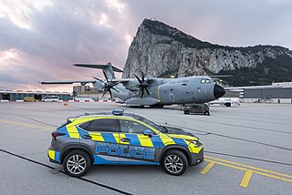
RAF Gibraltar is a Royal Air Force station on Gibraltar. No military aircraft are currently stationed there, but RAF, Commonwealth and aircraft of other NATO nations will periodically arrive for transient stopovers, exercises, or other temporary duty. Administered by British Forces Gibraltar, the station is a joint civil-military facility that also functions as the Rock's civilian airport – Gibraltar Airport, with the civilian airport's passenger terminal building and apron facilities located on the north side of the runway while the apron and hangar of RAF Gibraltar are located on the south side of the runway.

Naval Air Station Alameda was a United States Navy Naval Air Station in Alameda, California, on San Francisco Bay.

Watsonville Municipal Airport is three miles (5 km) northwest of Watsonville, in Santa Cruz County, California, United States. The airport covers 330 acres (134 ha) and has two runways. The largest aircraft to ever land at Watsonville were 05-5141 and 05-5143, C-17 Globemaster IIIs from March ARB, California.

Palm Beach County Park Airport is a county-owned, public-use airport in Palm Beach County, Florida, United States. It is located six nautical miles south of the central business district of West Palm Beach, Florida. This airport is included in the National Plan of Integrated Airport Systems for 2011–2015, which categorized it as a reliever airport. It is also commonly referred to as the Lantana Airport.

Naval Air Station Key West, is a naval air station and military airport located on Boca Chica Key, four miles (6 km) east of the central business district of Key West, Florida, United States.

Naval Air Station Glynco, Georgia, was an operational naval air station from 1942 to 1974 with an FAA airfield identifier of NEA and an ICAO identifier of KNEA.

Imeson Field, also known as Jacksonville Imeson Airport, was the airport serving Jacksonville, Florida, from 1927 until its closing in 1968. It was known as Jacksonville Municipal Airport prior to World War II, Jacksonville Army Airfield when the United States Army Air Forces controlled the facility during World War II, and at its closing the airport was Jacksonville – Thomas Cole Imeson Municipal Airport.
Kenitra Air Base is a military airport in Kenitra, a city in the Rabat-Salé-Kénitra region in Morocco. It is also known as the Third Royal Air Force Base, operated by the Royal Moroccan Air Force.
Carlsen Air Force Base is a former United States Army Air Forces World War II airbase on Trinidad, consisting of two landing strips, "Edinburgh" and "Xeres". The airbase also included an emergency landing strip, "Tobago".

Coast Guard Air Station Miami is an Air Station of the United States Coast Guard located at Opa-locka Executive Airport in Opa-locka, Florida. The station operates the HC-144 Ocean Sentry maritime patrol aircraft and the MH-65 Dolphin helicopter.
In the nation's quest to provide security along its lengthy coastlines, air reconnaissance was put forth by the futuristic Rear Admiral William A. Moffett. Through his efforts, two Naval Air Stations were commissioned in the early 1930s to port the Naval Airships (dirigibles) which he believed capable of meeting this challenge.
The United States Navy proposed to the U.S. Congress the development of a lighter-than-air station program for anti-submarine patrolling of the coast and harbors. This program proposed, in addition to the expansion at Naval Air Station and Lakehurst, the construction of new stations. The original contract was for steel hangars, 960 ft (290 m) long, 328 ft (100 m) wide and 190 ft (58 m) high, helium storage and service, barracks for 228 men, a power plant, landing mat, and a mobile mooring mast.

Chico Army Airfield auxiliary fields were a number of airfields used during World War II to support the Chico Army Airfield. On September 11, 1941, the US Army rented from the City of Chico a small 1930's airport that sat on 160 acres (0.65 km2) of land. The Airfield was five miles (8.0 km) north of the city center. The Army built up the small airport into the Chico Army Airfield. From the Chico Army Airfield operated the: United States Army Air Corps's Army Air Forces Basic Flying School, the Army Air Force Pilot School, the 10th Base Headquarters an Air Base Squadron and the 433rd Army Air Force Base Unit or Combat Crew Training Station of Fighter. To support the training of the many pilots, Chico Army Airfield operated a number of auxiliary airfields. Some auxiliary fields were no more than a landing strip runway, others were other operation airfield that supported the training at the Chico Army Airfield.

Merced Army Air Field auxiliary fields were built to support pilot training at the Merced Army Air Field. In 1940 the US Army wanted to built near Merced, California a 30,000 per year basic pilot training base. The former city of Cuba, Merced County, California near the Atchison, Topeka and Santa Fe Railway rail line was chosen at 37°22′50″N120°34′05″W at an elevation of 181 feet (55 m) for the main base, in Atwater, California. United States Army Air Corps leased the land from the City of Merced on 16 June 1941. Building the airbase school started on 8 July 1941 and opened on 20 September 1941 as a sub base of Army Air Forces Western Flying Training Command at Moffett Field. First called Air Corps Basic Flying School, Merced. The US Army moved part of the: 98th Bombardment Group, 539th School Squadrons, 540th School Squadrons, 541st School Squadrons, the 90th Air Base Squadron, and the 340th Material Squadron at Moffett Field to the new base in November 1941. The Air Corps Basic Flying School was renamed the Merced Army Flying School on 7 April 1942. To support the training auxiliary fields near the Merced Army Flying School were to be built for the flight training program. Merced Army Flying School was renamed the Merced Army Air Field in May 1943 and became part of the Western Flying Training Command.

Naval Air Station Los Alamitos Naval Outlying Landing Fields were a set airfield near Naval Air Station Los Alamitos to support the training of US Navy pilots during World War 2. The support airfields are called Naval Outlying Landing Field (NOLF). For the war, many new trained pilots were needed. The Naval Outlying Landing Fields provided a place for pilots to practice landing and take off without other air traffic. The remotes sites offered flight training without distractions. Most of the new pilots departed to the Pacific War after training. The Outlying Landing Fields had little or no support facilities. Naval Air Station Los Alamitos opened in 1942 and was transferred to the US Army in 1977 as Los Alamitos Army Airfield. Most of the Outlying fields closed in 1945, having completed the role of training new pilots. To open the needed Outlying Landing Fields quickly, the Navy took over local crop dusting and barnstorming airfields. Naval Air Station Los Alamitos was also called Los Alamitos Naval Reserve Air Base. During the war Marine Corps Air Station El Toro also used the outlying Landing Field. The Timm N2T Tutor was the most common plane used for training on the outlying landing fields.

Naval Base Trinidad, also called NAS Trinidad, NAS Port-of-Spain, was a large United States Navy Naval base built during World War II to support the many naval ships fighting and patrolling the Battle of the Atlantic. The fighting in the area became known as the Battle of the Caribbean. Naval Base Trinidad was located on the Island of Trinidad in West Indies of the Caribbean Sea.


