
Washington Parish is a parish located in the interior southeast corner of the U.S. state of Louisiana, one of the Florida Parishes. As of the 2020 census, the population was 45,463. Its parish seat is Franklinton. Its largest city is Bogalusa. The parish was founded in 1819.

Laurel is a city in and the second county seat of Jones County, Mississippi, United States. As of the 2020 census, the city had a population of 17,161. It is located northeast of Ellisville, the first county seat, which contains the first county courthouse. Laurel has the second county courthouse as there are two judicial districts in Jones County. Laurel is the headquarters of the Jones County Sheriff's Department, which administers in the county. Laurel is the principal city of a micropolitan statistical area named for it. Major employers include Howard Industries, Sanderson Farms, Masonite International, Family Health Center, Howse Implement, Thermo-Kool, and South Central Regional Medical Center. Laurel is home to the Lauren Rogers Museum of Art, Mississippi's oldest art museum, established by the family of Lauren Eastman Rogers.
Montpelier is an unincorporated community in eastern Muscatine County, Iowa, United States. Located along Iowa Highway 22, it lies on the Mississippi River above the city of Muscatine, the county seat of Muscatine County. Its elevation is 568 feet (173 m). The community is part of the Muscatine Micropolitan Statistical Area.
Benndale is a census-designated place and unincorporated community in George County, Mississippi. It is located near the intersection of State Highways 26 and 57. The community is part of the Pascagoula Metropolitan Statistical Area. Prior to the creation of George County, Benndale was located in Jackson County. It was first named as a CDP prior in the 2020 Census which listed a population of 65.
De Soto is a census-designated place and unincorporated community in Clarke County, Mississippi, United States.
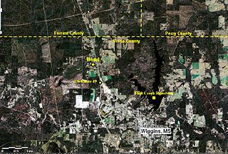
Bond is a census-designated place and unincorporated community in northern Stone County, Mississippi, United States. The community is situated approximately 3 miles (4.8 km) north of Wiggins on U.S. Route 49, and is part of the Gulfport-Biloxi metropolitan area. It was first named as a CDP in the 2020 Census which listed a population of 506.
Michigan City, formerly known as Davis Mills, is an unincorporated community in Benton County, Mississippi, United States. Although unincorporated, Michigan City has a post office, with the ZIP code of 38647.
Lake View is a census-designated place and unincorporated community located in DeSoto County, Mississippi, United States, near the Mississippi/Tennessee border just south of Memphis and north of the village of Walls. Lake View is located on the former Yazoo and Mississippi Valley Railroad.
Leaf is a census-designated place and unincorporated community in Greene County, Mississippi, United States.
Sykes is an unincorporated community in Clarke County, Mississippi, United States. Sykes is located on Mississippi Highway 18 8.8 miles (14.2 km) east-northeast of Quitman.
Bexley is an unincorporated place in George County, Mississippi.
The Wautubbee Formation is a geologic formation in Mississippi, United States. It preserves fossils dating back to the Paleogene period.
Yarbo is an unincorporated community in Washington County, Alabama, United States.
Logtown, Mississippi is a ghost town located in Hancock County, Mississippi. It is one of several ghost towns situated within the 125,000 acre acoustic buffer zone of NASA's John C. Stennis Space Center. It stood along the banks of the Pearl River and had been the site of a very large sawmill and logging community.
Basic is an unincorporated community in Clarke County, Mississippi, United States.
Mahned, also known as Mixons Mill, is an unincorporated community located in Perry County, Mississippi.
Carmichael is an unincorporated community in Clarke County, Mississippi, United States.
Lucien is an unincorporated community in Franklin County, Mississippi, United States.
Quentin is an unincorporated community in Franklin County, Mississippi, United States.
Avera is an unincorporated community in Greene County, Mississippi. Avera was originally located along the Chickasawhay River. The community was named for Powell Avera, who settled the area prior to 1860. Around 1880, the community was moved to its present location. The former location is now known as Old Avera.


