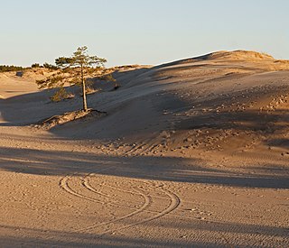
A dune is a landform composed of wind- or water-driven sand. It typically takes the form of a mound, ridge, or hill. An area with dunes is called a dune system or a dune complex. A large dune complex is called a dune field, while broad, flat regions covered with wind-swept sand or dunes with little or no vegetation are called ergs or sand seas. Dunes occur in different shapes and sizes, but most kinds of dunes are longer on the stoss (upflow) side, where the sand is pushed up the dune, and have a shorter slip face in the lee side. The valley or trough between dunes is called a dune slack.

A beach is a landform alongside a body of water which consists of loose particles. The particles composing a beach are typically made from rock, such as sand, gravel, shingle, pebbles, etc., or biological sources, such as mollusc shells or coralline algae. Sediments settle in different densities and structures, depending on the local wave action and weather, creating different textures, colors and gradients or layers of material.

Sedimentary rocks are types of rock that are formed by the accumulation or deposition of mineral or organic particles at the Earth's surface, followed by cementation. Sedimentation is the collective name for processes that cause these particles to settle in place. The particles that form a sedimentary rock are called sediment, and may be composed of geological detritus (minerals) or biological detritus. The geological detritus originated from weathering and erosion of existing rocks, or from the solidification of molten lava blobs erupted by volcanoes. The geological detritus is transported to the place of deposition by water, wind, ice or mass movement, which are called agents of denudation. Biological detritus was formed by bodies and parts of dead aquatic organisms, as well as their fecal mass, suspended in water and slowly piling up on the floor of water bodies. Sedimentation may also occur as dissolved minerals precipitate from water solution.
Transverse waves are the waves which are perpendicular to the wave motion.

Deposition is the geological process in which sediments, soil and rocks are added to a landform or landmass. Wind, ice, water, and gravity transport previously weathered surface material, which, at the loss of enough kinetic energy in the fluid, is deposited, building up layers of sediment.

Aeolian processes, also spelled eolian, pertain to wind activity in the study of geology and weather and specifically to the wind's ability to shape the surface of the Earth. Winds may erode, transport, and deposit materials and are effective agents in regions with sparse vegetation, a lack of soil moisture and a large supply of unconsolidated sediments. Although water is a much more powerful eroding force than wind, aeolian processes are important in arid environments such as deserts.

In fluid dynamics, wind waves, or wind-generated waves, are water surface waves that occur on the free surface of bodies of water. They result from the wind blowing over a fluid surface, where the contact distance in the direction of the wind is known as the fetch. Waves in the oceans can travel thousands of miles before reaching land. Wind waves on Earth range in size from small ripples, to waves over 100 ft (30 m) high, being limited by wind speed, duration, fetch, and water depth.

Internal waves are gravity waves that oscillate within a fluid medium, rather than on its surface. To exist, the fluid must be stratified: the density must change with depth/height due to changes, for example, in temperature and/or salinity. If the density changes over a small vertical distance, the waves propagate horizontally like surface waves, but do so at slower speeds as determined by the density difference of the fluid below and above the interface. If the density changes continuously, the waves can propagate vertically as well as horizontally through the fluid.

Diver navigation, termed "underwater navigation" by scuba divers, is a set of techniques—including observing natural features, the use of a compass, and surface observations—that divers use to navigate underwater. Free-divers do not spend enough time underwater for navigation to be important, and surface supplied divers are limited in the distance they can travel by the length of their umbilicals and are usually directed from the surface control point. On those occasions when they need to navigate they can use the same methods used by scuba divers.

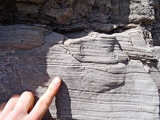
In geology, cross-bedding, also known as cross-stratification, is layering within a stratum and at an angle to the main bedding plane. The sedimentary structures which result are roughly horizontal units composed of inclined layers. The original depositional layering is tilted, such tilting not being the result of post-depositional deformation. Cross-beds or "sets" are the groups of inclined layers, which are known as cross-strata.

In geology, ripple marks are sedimentary structures and indicate agitation by water or wind.

Sole marks are sedimentary structures found on the bases of certain strata, that indicate small-scale grooves or irregularities. This usually occurs at the interface of two differing lithologies and/or grain sizes. They are commonly preserved as casts of these indents on the bottom of the overlying bed. This is similar to casts and molds in fossil preservation. Occurring as they do only at the bottom of beds, and their distinctive shapes, they can make useful way up structures and paleocurrent indicators.

In geology, depositional environment or sedimentary environment describes the combination of physical, chemical and biological processes associated with the deposition of a particular type of sediment and, therefore, the rock types that will be formed after lithification, if the sediment is preserved in the rock record. In most cases the environments associated with particular rock types or associations of rock types can be matched to existing analogues. However, the further back in geological time sediments were deposited, the more likely that direct modern analogues are not available.
Sedimentary structures include all kinds of features formed at the time of deposition. Sediments and sedimentary rocks are characterized by bedding, which occurs when layers of sediment, with different particle sizes are deposited on top of each other. These beds range from millimeters to centimeters thick and can even go to meters or multiple meters thick.

An antidune is a bedform found in fluvial and other channeled environments. Antidunes occur in supercritical flow, meaning that the Froude number is greater than 1.0 or the flow velocity exceeds the wave velocity; this is also known as upper flow regime. In antidunes, sediment is deposited on the upstream (stoss) side and eroded from the downstream (lee) side, opposite lower flow regime bedforms. As a result, antidunes migrate in an upstream direction, counter to the current flow. Antidunes are called in-phase bedforms, meaning that the water surface elevation mimics the bed elevation; this is due to the supercritical flow regime. Antidune bedforms evolve rapidly, growing in amplitude as they migrate upstream. The resultant wave at the water's surface also increases in amplitude. When that wave becomes unstable, breaks and washes downstream, much of the antidune bedform may be destroyed.
Hummocky cross-stratification is a type of sedimentary structure found in sandstones. It is a form of cross-bedding usually formed by the action of large storms, such as hurricanes. It takes the form of a series of "smile"-like shapes, crosscutting each other. It is only formed at a depth of water below fair-weather wave base and above storm-weather wave base. They are not related to "hummocks" except in shape.
Aeolian landforms are features produced by either the erosive or constructive action of the wind. These features may be built up from sand or snow, or eroded into rock, snow, or ice. Aeolian landforms are commonly observed in sandy deserts and on frozen lakes or sea ice and have observed and studied across Earth and on other planets, including Mars and Pluto

A bedform is a feature that develops at the interface of fluid and a moveable bed, the result of bed material being moved by fluid flow. Examples include ripples and dunes on the bed of a river. Bedforms are often preserved in the rock record as a result of being present in a depositional setting. Bedforms are often characteristic to the flow parameters, and may be used to infer flow depth and velocity, and therefore the Froude number.
Heterolithic bedding is a sedimentary structure made up of interbedded deposits of sand and mud. It is formed mainly in tidal flats but can also be formed in glacial environments. Examples from fluvial environments have been documented but are rare. Heterolithic bedding forms in response to alternations in sediment supply and tidal velocity. The fluctuations result in the interbedded layers of sand and mud. The rippled sand layer is formed during high tidal currents, while the mud is deposited during slack tide periods .The three main types of heterolithic bedding are flaser, wavy, and lenticular. Starved ripples and cross bedding with flasers can also be considered forms of heterolithic bedding. Differentiating of these various types of heterolithic bedding is based on the relative volume of mud and sand. This key determining factor is controlled by the timing, and duration of both the high tide, and slack tide depositional periods.
Periodic Bedrock Ridges (PBRs) are features of the surface geomorphology of Mars and formerly unknown on Earth, first described in a paper in the Journal of Geological Research - Planets, in March 2012, by Professor David R. Montgomery, Joshua L. Bandfield, and Scott K. Becker of the University of Washington. Periodic Bedrock Ridges (PBRs) have also been identified at the ExoMars 2022 landing site, Oxia Planum, which show that the landing site experienced multiple climatic changes in the Amazonian.


