Weatogue, Connecticut

Last updated
Weatogue, Connecticut
Weatogue Post Office, May 2023.jpg
Weatogue Post Office
USA Connecticut location map.svg
Red pog.svg
Weatogue
Usa edcp location map.svg
Red pog.svg
Weatogue
Coordinates: 41°50′37″N72°49′42″W / 41.84361°N 72.82833°W / 41.84361; -72.82833
CountryUnited States
State Connecticut
County Hartford
Town Simsbury
Area
  Total3.02 sq mi (7.81 km2)
  Land3.00 sq mi (7.76 km2)
  Water0.02 sq mi (0.05 km2)
Elevation
300 ft (90 m)
Population
 (2010)
  Total2,776
  Density926/sq mi (357.7/km2)
Time zone UTC-5 (Eastern)
  Summer (DST) UTC-4 (Eastern)
ZIP code
06089
Area code 860
FIPS code 09-80770
GNIS feature ID2377877

Weatogue is a village [1] and census-designated place in Simsbury, Hartford County, Connecticut. The population was 2,776 at the 2010 census. [2]

Contents

Geography

Weatogue is in the southern part of the town of Simsbury and is bordered to the northwest by West Simsbury and to the northeast by Simsbury Center. The northern border of the CDP follows Town Forest Road, Stratton Brook Road, a small portion of U.S. Route 202, and Second Brook to its mouth in the Farmington River. The eastern border of the CDP follows the river south (upstream) to Minister Brook. The southern border follows Minister Brook, US 202, and Old Meadow Plain Road, and the western border follows Pine Glen Road, Park Road, Orchard Lane, and Overlook Terrace to Connecticut Route 167, from which point the border strikes northwest to Town Forest Road at Nimrod Road. The original settlement of Weatogue is in the eastern part of the CDP, at the junction of US 202 (Hopmeadow Street) with Canal Street and Stratton Brook Road.

According to the United States Census Bureau, the CDP has a total area of 3.02 square miles (7.81 km2), of which 3.00 square miles (7.76 km2) is land and 0.019 square miles (0.05 km2), or 0.66%, is water. [2]

Demographics

As of the census [3] of 2000, there were 2,805 people, 1,007 households, and 815 families residing in the CDP. The population density was 935.0 inhabitants per square mile (361.0/km2). There were 1,031 housing units at an average density of 343.6 per square mile (132.7/km2). The racial makeup of the CDP was 95.65% White, 0.75% African American, 0.04% Native American, 2.35% Asian, 0.04% Pacific Islander, 0.25% from other races, and 0.93% from two or more races. Hispanic or Latino of any race were 1.71% of the population.

There were 1,007 households, out of which 44.8% had children under the age of 18 living with them, 73.1% were married couples living together, 5.6% had a female householder with no husband present, and 19.0% were non-families. 16.1% of all households were made up of individuals, and 4.8% had someone living alone who was 65 years of age or older. The average household size was 2.79 and the average family size was 3.15.

In the CDP the population was spread out, with 30.3% under the age of 18, 3.5% from 18 to 24, 29.1% from 25 to 44, 26.8% from 45 to 64, and 10.3% who were 65 years of age or older. The median age was 39 years. For every 100 females, there were 96.8 males. For every 100 females age 18 and over, there were 91.2 males.

The median income for a household in the CDP was $88,654, and the median income for a family was $93,761. Males had a median income of $66,071 versus $46,635 for females. The per capita income for the CDP was $39,652. About 1.0% of families and 1.4% of the population were below the poverty line, including 2.3% of those under age 18 and 3.0% of those age 65 or over.

Related Research Articles

<span class="mw-page-title-main">Broad Brook, Connecticut</span> Census-designated place in Connecticut, United States

Broad Brook is a neighborhood and census-designated place (CDP) in the town of East Windsor, Hartford County, Connecticut, United States. As of the 2010 census, the CDP population was 4,069.

Tariffville is a neighborhood and census-designated place (CDP) in the town of Simsbury in Hartford County, Connecticut, United States. The population was 1,324 at the 2010 census. It is a popular location for whitewater paddlers who use the Farmington River.

<span class="mw-page-title-main">West Simsbury, Connecticut</span> Census-designated place in Connecticut, United States

West Simsbury is a census-designated place (CDP) and section of the town of Simsbury in Hartford County, Connecticut, United States. The population of the CDP was 2,447 at the 2010 census.

Simsbury Center is a census-designated place (CDP) that consists of the central settlement, and the neighborhoods immediately surrounding it, in the town of Simsbury, Connecticut, in the United States. As of the 2010 census, the CDP had a population of 5,836. The core area of the CDP is listed as the Simsbury Center Historic District on the National Register of Historic Places.

<span class="mw-page-title-main">Bethel (CDP), Connecticut</span> Census-designated place in Connecticut, United States

Bethel is a census-designated place (CDP) in Fairfield County, Connecticut, United States. It comprises the primary village and surrounding residential land within the town of Bethel. As of the 2010 census, the population of the CDP was 9,549, out of 18,584 in the entire town.

<span class="mw-page-title-main">Ridgefield (CDP), Connecticut</span> Census-designated place in Connecticut, United States

Ridgefield is a census-designated place (CDP) in Fairfield County, Connecticut, United States. It consists of the primary central village in the town of Ridgefield and surrounding residential areas. As of the 2010 census, the population of the CDP was 7,645, out of 24,638 in the entire town.

<span class="mw-page-title-main">New Milford (CDP), Connecticut</span> Census-designated place in Connecticut, United States

New Milford is a census-designated place (CDP) in Litchfield County, Connecticut, United States. It comprises the main population center within the town of New Milford. As of the 2010 census, the population of New Milford was 6,523, out of 28,142 in the entire town of New Milford.

<span class="mw-page-title-main">Belchertown (CDP), Massachusetts</span> Census-designated place in Massachusetts, United States

Belchertown is a census-designated place (CDP) comprising the central village in the town of Belchertown in Hampshire County, Massachusetts, United States. The population was 2,899 at the 2010 census, out of a total town population of 14,649. It is part of the Springfield, Massachusetts Metropolitan Statistical Area.

<span class="mw-page-title-main">Granby (CDP), Massachusetts</span> Census-designated place in Massachusetts, United States

Granby is a census-designated place (CDP) comprising the main village in the town of Granby in Hampshire County, Massachusetts, United States. The population of the CDP was 1,368 at the 2010 census, out of a total town population of 6,240. It is part of the Springfield, Massachusetts Metropolitan Statistical Area.

<span class="mw-page-title-main">Winchester (CDP), New Hampshire</span> Census-designated place in New Hampshire, United States

Winchester is a census-designated place (CDP) and the main village in the town of Winchester in Cheshire County, New Hampshire, United States. The population of the CDP was 1,606 at the 2020 census, compared to 4,150 in the entire town.

Hanover is a census-designated place (CDP) and the main village in the town of Hanover in Grafton County, New Hampshire, United States. The population of the CDP was 9,078 at the 2020 census, out of 11,870 in the entire town. The CDP includes the campus of Dartmouth College.

<span class="mw-page-title-main">Hampton (CDP), New Hampshire</span> Census-designated place in New Hampshire, United States

Hampton is a census-designated place (CDP) comprising the town center and surrounding developed areas of the town of Hampton, Rockingham County, New Hampshire, United States. The population of the CDP was 9,597 at the 2020 census, out of 16,214 in the entire town.

<span class="mw-page-title-main">Bethlehem Village, Connecticut</span> Census-designated place in Connecticut, United States

Bethlehem Village is a census-designated place (CDP) within the town of Bethlehem in Litchfield County, Connecticut, United States. The CDP includes the Bethlehem Green Historic District at the town center, as well as surrounding residential and rural land. As of the 2010 census, the CDP had a population of 2,021, out of a population of 3,607 for the entire town of Bethlehem.

<span class="mw-page-title-main">New Hartford Center, Connecticut</span> Census-designated place in Connecticut, United States

New Hartford Center is a census-designated place (CDP) in Litchfield County, Connecticut, United States. It comprises the village of New Hartford, the adjacent Pine Meadow Historic District, and some surrounding forest land, all within the town of New Hartford. As of the 2010 census, the population of New Hartford Center was 1,385, out of 6,970 in the entire town of New Hartford.

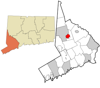
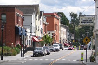
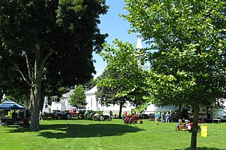
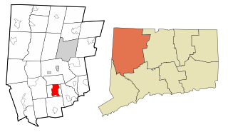
Salmon Brook is the name of a census-designated place (CDP) corresponding to the village of Granby, the primary settlement of the town of Granby, Connecticut, in Hartford County. The population of the CDP was 2,324 as of the 2010 census.

<span class="mw-page-title-main">Walpole (CDP), New Hampshire</span> Census-designated place in New Hampshire, United States

Walpole is a census-designated place (CDP) and the central village in the town of Walpole in Cheshire County, New Hampshire, United States. The population of the CDP was 573 at the 2020 census, compared to 3,633 in the entire town.

<span class="mw-page-title-main">Greenwich (CDP), Connecticut</span> Census-designated place in Connecticut, United States

Greenwich is a census-designated place (CDP) in Fairfield County, Connecticut, United States. It is one of several CDPs within the town of Greenwich and corresponds to the historic municipal center of the town and surrounding residential and commercial areas. As of the 2010 census, the population of the Greenwich CDP was 12,942, out of 61,171 in the entire town.

<span class="mw-page-title-main">Watertown (CDP), Connecticut</span> Census-designated place in Connecticut, United States

Watertown is a census-designated place (CDP) in Litchfield County, Connecticut, United States. It comprises the central village of the town of Watertown. As of the 2010 census, the population of the CDP was 3,574, out of 22,514 in the entire town.

<span class="mw-page-title-main">Norfolk (CDP), Connecticut</span> Census-designated place in Connecticut, United States

Norfolk is a census-designated place (CDP) in Litchfield County, Connecticut, United States. It is the central village within the town of Norfolk. As of the 2010 census, the population of the CDP was 553, out of 1,709 in the entire town.

<span class="mw-page-title-main">Thomaston (CDP), Connecticut</span> Census-designated place in Connecticut, United States

Thomaston is a census-designated place (CDP) in Litchfield County, Connecticut, United States. It comprises the downtown portion of the town of Thomaston. As of the 2010 census, the population of the CDP was 1,910, out of 7,887 in the entire town.

References

  1. Principal Communities in Connecticut, Dept. of Economic and Community Development
  2. 1 2 "Geographic Identifiers: 2010 Demographic Profile Data (G001): Weatogue CDP, Connecticut". U.S. Census Bureau, American Factfinder. Archived from the original on February 12, 2020. Retrieved November 30, 2012.
  3. "U.S. Census website". United States Census Bureau . Retrieved 2008-01-31.