Related Research Articles

The Gulf of St. Lawrence is the outlet of the North American Great Lakes via the St. Lawrence River into the Atlantic Ocean. The gulf is a semi-enclosed sea, covering an area of about 226,000 square kilometres (87,000 sq mi) and containing about 34,500 cubic kilometres (8,300 cu mi) of water, at an average depth of 152 metres (500 ft).

The Arctic Archipelago, also known as the Canadian Arctic Archipelago, is an archipelago lying to the north of the Canadian continental mainland, excluding Greenland and Iceland.

Arrowsic is a town in Sagadahoc County, Maine, United States. The population is 477 as of the 2020 United States Census. It is part of the Portland–South Portland–Biddeford, Maine metropolitan statistical area. During the French and Indian Wars, Arrowsic was site of a succession of important and embattled colonial settlements. It is a favorite with artists and birdwatchers.

The Celebes Sea, or Sulawesi Sea, of the western Pacific Ocean is bordered on the north by the Sulu Archipelago and Sulu Sea and Mindanao Island of the Philippines, on the east by the Sangihe Islands chain, on the south by Sulawesi's Minahasa Peninsula, and on the west by northern Kalimantan in Indonesia. It extends 420 miles (675 km) north-south by 520 mi (840 km) east-west and has a total surface area of 110,000 square miles (280,000 km2), to a maximum depth of 20,300 feet (6,200 m). South of the Cape Mangkalihat, the sea opens southwest through the Makassar Strait into the Java Sea.

This is a list of the extreme points of North America: the points that are highest and lowest, and farther north, south, east or west than any other location on the continent. Some of these points are debatable, given the varying definitions of North America.
Isle Madame is an island off southeastern Cape Breton Island in Nova Scotia. It is part of the Municipality of the County of Richmond.

The Cape San Blas Light is a lighthouse in the state of Florida in the United States. There were four built between 1849 and 1885. It was located at Cape San Blas in the northwestern part of the state. Due to beach erosion and weather damage over the decades, it was moved in 2014 to Port St. Joe. The lighthouse was listed on the National Register of Historic Places in 2015.

Grindstone is a former village municipality located on Grindstone Island in Quebec's Magdalen Islands. The previous municipal government was, on 1 January 2002, incorporated into the urban agglomeration of the Les Îles-de-la-Madeleine municipality.
Henry Island is an island located in the Gulf of Saint Lawrence in the Northumberland Strait of Nova Scotia, Canada, just east of Prince Edward Island and southwest of Port Hood Island.

Ahlmann Glacier is the southernmost of two glaciers on the east side of Hemimont Plateau flowing east into Seligman Inlet on Bowman Coast, Graham Land in Antarctica.
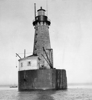
The Stannard Rock Light, completed in 1883, is a lighthouse located on a reef that was the most serious hazard to navigation on Lake Superior. The exposed crib of the Stannard Rock Light is rated as one of the top ten engineering feats in the United States. It is 24 miles (39 km) from the nearest land, making it the most distant lighthouse in the United States. It was one of the "stag stations", manned only by men, and had the nickname "The Loneliest Place in the World".

Bluie was the United States military code name for Greenland during World War II. It is remembered by the numbered sequence of base locations identified by the 1941 United States Coast Guard South Greenland Survey Expedition, and subsequently used in radio communications by airmen unfamiliar with pronunciation of the Inuit and Old Norse names of those locations. These were typically spoken BLUIE (direction) (number), with direction being east or west along the Greenland coast from Cape Farewell.

The borders of the oceans are the limits of Earth's oceanic waters. The definition and number of oceans can vary depending on the adopted criteria. The principal divisions of the five oceans are the Pacific Ocean, Atlantic Ocean, Indian Ocean, Southern (Antarctic) Ocean, and Arctic Ocean. Smaller regions of the oceans are called seas, gulfs, bays, straits, and other terms. Geologically, an ocean is an area of oceanic crust covered by water.

Furness Glacier is a small glacier flowing between Cape Belsham and Point Wild to the north coast of Elephant Island, South Shetland Islands. It was charted and named by the Ernest Shackleton Endurance expedition 1914–16.
Gruening Glacier is a broad glacier descending southeast between steep rock walls to the northwest part of Hilton Inlet, on the east coast of Palmer Land, Antarctica. It was discovered by the United States Antarctic Service (USAS) in a flight down this glacier from East Base on December 30, 1940, and was named for Ernest H. Gruening, Director of the Division of Territories and Island Possessions, U.S. Department of the Interior, during the inception of the USAS, and a member of the Executive Committee by which the USAS was directed; later U.S. Senator from Alaska.
Green Glacier is a glacier on the east side of Graham Land, Antarctica, 15 nautical miles (28 km) long and 4 nautical miles (7 km) wide, flowing from the plateau northeast between Dugerjav Peak and Rugate Ridge, and then east into Vaughan Inlet next north of Pirne Peak and south of the terminus of Hektoria Glacier.
The SS Arrow was an oil tanker built by Bethlehem Steel Company, Sparrows Point, Baltimore, Maryland in 1948 as the tanker Olympic Games. Renamed Sea Robin in 1960 and finally Arrow in 1962, the ship was a Liberian-registered tanker owned by the Sun Navigation Company. At 551.2 feet in length and 68.3 feet in width, with a draft of 29.9 feet, she was an enlarged version of the standard American World War II tanker design and one of the oldest tankers in the fleet of Aristotle Onassis. The Arrow ran aground and spilled its load of oil into Chedabucto Bay on February 4, 1970. This remains the most significant oil spill off Canada’s East Coast, with some 10,000 tonnes. Only the MV Kurdistan accident has come close, spilling about 6,000 tons of oil after breaking apart in the Cabot Strait on March 15, 1979.
References
- ↑ Lesley Choyce (March 1, 1997). "Thin edge of the wedge (Wedge Island)". Canadian Geographic.
Coordinates: 45°00′N61°52′W / 45.000°N 61.867°W
| | This Guysborough County, Nova Scotia location article is a stub. You can help Wikipedia by expanding it. |