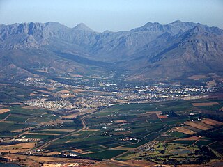
Stellenbosch is a town in the Western Cape province of South Africa, situated about 50 kilometres east of Cape Town, along the banks of the Eerste River at the foot of the Stellenbosch Mountain. The town became known as the City of Oaks or Eikestad in Afrikaans and Dutch due to the large number of oak trees that were planted by its founder, Simon van der Stel, to grace the streets and homesteads.

Stellenbosch Local Municipality is the local municipality that governs the towns of Stellenbosch, Franschhoek and Pniel, and the surrounding rural areas, in the Western Cape province of South Africa. It covers an area of 831 square kilometres (321 sq mi) and, as of 2011, had a population of 155,733 people in 43,420 households. It falls within the Cape Winelands District Municipality.

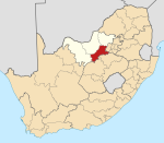
The Waterberg is a mountainous massif of approximately 654,033 hectare in north Limpopo Province, South Africa. The average height of the mountain range is 600 m with a few peaks rising up to 2000 m above sea level. Vaalwater town is located just north of the mountain range. The extensive rock formation was shaped by hundreds of millions of years of riverine erosion to yield diverse bluff and butte landform. The ecosystem can be characterised as a dry deciduous forest or Bushveld. Within the Waterberg there are archaeological finds dating to the Stone Age, and nearby are early evolutionary finds related to the origin of humans.
Odzala-Kokoua National Park is a national park in the Republic of the Congo. The park was first protected in 1935, declared a biosphere reserve in 1977, and granted official designation by presidential decree in 2001. Odzala-Kokoua has approximately 100 mammals species, and one of the continent's most diverse primate populations. The nonprofit conservation organization African Parks began managing the park in collaboration with the Ministry of Forest Economy, Sustainable Development and Environment of the Republic of the Congo in 2010.

Heartwater is a tick-borne rickettsial disease. The name is derived from the fact that fluid can collect around the heart or in the lungs of infected animals. It is caused by Ehrlichia ruminantium - an intracellular Gram-negative coccal bacterium. The disease is spread by various Amblyomma ticks, and has a large economic impact on cattle production in affected areas. There are four documented manifestations of the disease, these are acute, peracute, subacute, and a mild form known as heartwater fever. There are reports of zoonotic infections of humans by E. ruminantium, similar to other Ehrlichia species, such as those that cause human ehrlichiosis.
Welgevonden Game Reserve,, is in the Waterberg District, of the Limpopo, province of South Africa. Welgevonden Game Reserve,, is a 38,200ha game reserve in the Waterberg District, of the Limpopo Province of South Africa.
The Sishen mine is a large iron mine located in central South Africa in Kathu, Northern Cape. Sishen represents one of the largest iron ore reserves in South Africa and in the world having estimated reserves of 2.43 billion tonnes of ore grading 58.6% iron metal.

Pareiasauromorpha is a group of parareptilian amniotes from the Permian. It includes genera found all over the world, with many genera from Asia and South Africa. The clade was first used as a group by Linda A. Tsuji in 2011, in order to group the family Nycteroleteridae (nycteroleters) and the superfamily Pareiasauroidea (pareiasaurs). Pareiasauromorpha is considered to be a monophyletic node, the sister group to procolophonoids.
The Gupta family is a wealthy Indian-born family with business interests in South Africa, whose most notable members are brothers Ajay, Atul, and Rajesh "Tony" Gupta—as well as Atul's nephews Varun, and US-based Ashish and Amol. The family owns a business empire spanning computer equipment, media, and mining. The family name became synonymous with corruption in South Africa and they have been sanctioned by multiple countries for their activities.
Embhuleni is the royal village of the eSwatini kingdom in South Africa's Mpumalanga province. It is now called Embhuleni Traditional Council or Embhuleni Royal Kraal and is one of South Africa's tribal authorities represented in the House of Traditional Leaders. Built by King Mswati II in the mid-19th century as a military post to safeguard eSwatini land against a possible invasion by the Bapedi people before the Scramble for Africa, its official residence known as Embhuleni Royal Kraal is in Badplaas and is now responsible for administering the cultural affairs of the Swati people in Mpumalanga