
Hawke's Bay is a region on the east coast of New Zealand's North Island. The region is named for Hawke Bay, which was named in honour of Edward Hawke. The region's main centres are the cities of Napier and Hastings, while the more rural parts of the region are served by the towns of Waipukurau, Waipawa, and Wairoa.

The provinces of the Colony of New Zealand existed as a form of sub-national government. Initially established in 1846 when New Zealand was a Crown colony without responsible government, two provinces were first created. Each province had its own legislative council and governor. With the passing of the New Zealand Constitution Act 1852 the provinces were recreated around the six planned settlements or "colonies". By 1873 the number of provinces had increased to nine, but they had become less isolated from each other and demands for centralised government arose. In 1875 the New Zealand Parliament decided to abolish the provincial governments, and they came to an end in November 1876. They were superseded by counties, which were later replaced by territorial authorities.
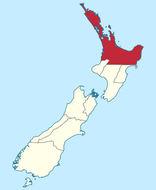
Manawatū-Whanganui is a region in the lower half of the North Island of New Zealand, whose main population centres are the cities of Palmerston North and Whanganui. It is administered by the Manawatū-Whanganui Regional Council, which operates under the name Horizons Regional Council.

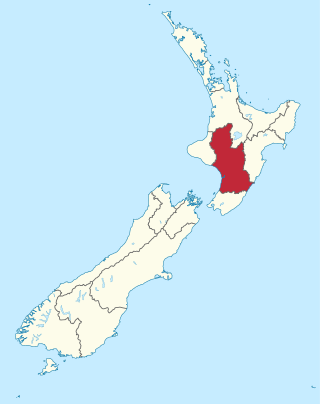
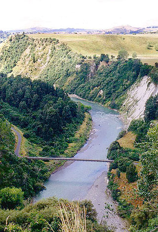
The Rangitikei District is a territorial authority district located primarily in the Manawatū-Whanganui region in the North Island of New Zealand, although a small part, the town of Ngamahanga, lies in the Hawke's Bay Region. It is located in the southwest of the island, and follows the catchment area of the Rangitīkei River.
Bunnythorpe is a village in the Manawatū-Whanganui region of New Zealand's North Island, 10 km (6 mi) north of the region's major city, Palmerston North. Dairy farms predominate the surrounding area but the community facilities include Bunnythorpe School, with a roll of about 80 pupils as of 2010 as well as a Rugby Football Club, Country Club and several manufacturing plants. The population was 687 in the 2018 census.
Powerco is the largest dual-energy distribution company in New Zealand by length, and is one of only two dual-energy distributors in the country.
The Auckland Province was a province of New Zealand from 1853 until the abolition of provincial government in 1876.

Triennial elections for all 73 cities and districts, twelve regional councils and all district health boards (DHBs) in New Zealand were held on 13 October 2007. Most councils were elected using the first-past-the-post voting method, but eight were elected using single transferable vote.

The Hawke Cup is a non-first-class cricket competition for New Zealand's district associations. Apart from 1910–11, 1912–13 and 2000–01 the competition has always been on a challenge basis. To win the Hawke Cup, the challengers must beat the holders, either outright or on the first innings in a drawn match, on the holders' home ground.

Rangitāne is a Māori iwi (tribe). Their rohe (territory) is in the Manawatū, Horowhenua, Wairarapa and Marlborough areas of New Zealand.
Superintendent was the elected head of each Provincial Council in New Zealand from 1853 to 1876.
Wanganui and Rangitikei is a former parliamentary electorate that existed from 1853 to 1860. It was represented by two Members of Parliament.
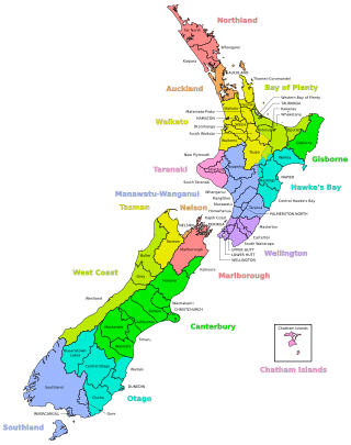
A district in New Zealand is a territorial authority area governed by a district council as a second-tier of local government in New Zealand, below regional councils. They were formed as a result of the local government reforms in 1989. There are 53 districts in New Zealand, and they do not include the 12 city councils, the Auckland Council, and the Chatham Islands Council. District councils serve a combination of rural and urban communities, while city councils administer the larger urban areas. Three districts are unitary authorities also performing the functions of a regional council.
Hawke's Bay was a parliamentary electorate in the Hawke's Bay Region of New Zealand from 1881 to 1996. In 1986 it was renamed Hawkes Bay.
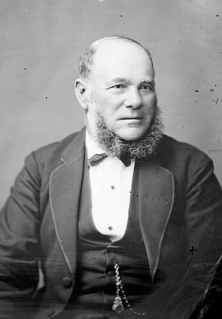
William Hogg Watt (1818–1893) was a 19th-century Member of Parliament in the Manawatū region of New Zealand.
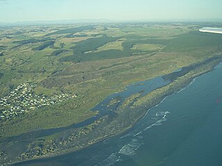
Koitiata is a settlement located in the southwestern part of Rangitikei District of the Manawatū-Whanganui region of New Zealand's North Island. At the time of the 2018 census, Koitiata had a population of 126. Marton is located 24 km to the east and Whanganui is located 29 km to the northwest. Nearby Koitiata is Lake Koitiata.

Ngamahanga is a rural community, in the northeastern part of Rangitikei District, in the Hawke's Bay region of New Zealand's North Island. The rest of the Rangitikei District is located in the Manawatū-Whanganui region.
Porewa is a rural community, in the Rangitikei District of the Manawatū-Whanganui region of New Zealand's North Island.
The Mayor of Rangitikei is the head of the Rangitikei District Council in New Zealand. The role was created in 1989 with the formation of the Rangitikei District as part of the 1989 local government reforms. The current mayor since 2013 is Andy Watson from Marton.
The Whanganui cricket team represents the Whanganui District on the south-west coast of New Zealand's North Island. It also covers the adjoining areas of Rangitikei, Ruapehu and Waverley.


